This quiz is based on UPSC STATIC SYLLABUS and is posted regularly on the PWOnlyIAS website for UPSC IAS.
To view Solutions, follow these instructions:
To Start quiz click on – ‘Start Quiz’
Solve all Questions.
Click on ‘Quiz Summary’
Click on ‘Finish Quiz’
Click on ‘View Questions’ button to see the all Explanations.
You have already completed the quiz before. Hence you can not start it again.
Quiz is loading...
You must sign in or sign up to start the quiz.
You have to finish following quiz, to start this quiz:
Results
0 of 5 questions answered correctly
Your time:
Time has elapsed
You have reached 0 of 0 points, (0)
Average score
Your score
Categories
Not categorized0%
Your result has been entered into leaderboard
Loading
maximum of 10 points
Pos.
Name
Entered on
Points
Result
Table is loading
No data available
1
2
3
4
5
Answered
Review
Question 1 of 5
1. Question
2 points
Which of the following is/are characteristic of the young stage of river development ?
Well-integrated flow with numerous tributaries and well developed floodplains.
Waterfalls and rapids may exist in the region where hard rocks are found.
Rives flowing in the Himalayan region are generally dynamic at a young stage.
Select the correct answer using the code given below.
Correct
Ans: B
Exp:
Statement 1 is incorrect: Well-integrated flow with numerous tributaries and well developed floodplains are the features of the OLD stage of the river.
Statement 2 is correct: Waterfalls and rapids are the main features of rivers in their youthful stages, where local hard rock bodies are exposed.
Statement 3 is correct: The Himalayan region’s young rivers are often dynamic and play a significant role in shaping the landscape. They erode and transport vast amounts of sediment, creating impressive gorges, canyons, and valleys as they flow through the rugged terrain.
Incorrect
Ans: B
Exp:
Statement 1 is incorrect: Well-integrated flow with numerous tributaries and well developed floodplains are the features of the OLD stage of the river.
Statement 2 is correct: Waterfalls and rapids are the main features of rivers in their youthful stages, where local hard rock bodies are exposed.
Statement 3 is correct: The Himalayan region’s young rivers are often dynamic and play a significant role in shaping the landscape. They erode and transport vast amounts of sediment, creating impressive gorges, canyons, and valleys as they flow through the rugged terrain.
Question 2 of 5
2. Question
2 points
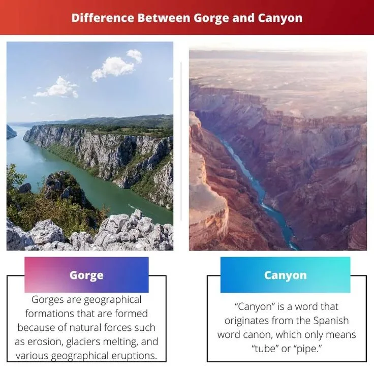
Consider the following statements regarding Gorges and Canyon:
A gorge is a deep valley with very steep sides, and the canyon is characterised by steep, step-like side slopes.
A gorge is wider at its top than at its bottom, and a canyon is almost equal in width at its top as well as its bottom.
Which of the Statements given above is/are correct?
Correct
Ans: A
Exp:
Statement 1 is correct: A gorge and a canyon are both geological landforms associated with the erosional features of rivers with deep valleys, but they have some distinguishing characteristics. A gorge is a deep valley with very steep to straight sides, and the canyon is characterised by steep step-like side slopes.
Statement 2 is incorrect: A gorge is almost equal in width at its top as well as its bottom. In contrast, a canyon is wider at its top than at its bottom.
Incorrect
Ans: A
Exp:
Statement 1 is correct: A gorge and a canyon are both geological landforms associated with the erosional features of rivers with deep valleys, but they have some distinguishing characteristics. A gorge is a deep valley with very steep to straight sides, and the canyon is characterised by steep step-like side slopes.
Statement 2 is incorrect: A gorge is almost equal in width at its top as well as its bottom. In contrast, a canyon is wider at its top than at its bottom.
Question 3 of 5
3. Question
2 points
With reference to Karst topography, consider the following statements:
It is mainly produced by the action of groundwater.
Karst topography has erosional landforms only.
Which of the Statements given above is/are correct?
Correct
Ans: A
Exp:
Statement 1 is correct: Karst topography, often referred to simply as “karst,” is a distinctive landscape that results from the dissolution of soluble rocks, primarily limestone, gypsum, and dolomite. It is characterised by various unique surface features, including sinkholes, caves, disappearing streams, underground drainage systems, and limestone pavements. Any limestone or dolomitic region showing typical landforms produced by the action of groundwater through the processes of solution and deposition is called Karst topography.
Statement 2 is incorrect: In karst topography, both erosional and depositional landforms are active in the formation of landforms like Pools, Sinkholes, lapies, limestone pavements; and stalactites, stalagmites, and pillars, respectively.
Incorrect
Ans: A
Exp:
Statement 1 is correct: Karst topography, often referred to simply as “karst,” is a distinctive landscape that results from the dissolution of soluble rocks, primarily limestone, gypsum, and dolomite. It is characterised by various unique surface features, including sinkholes, caves, disappearing streams, underground drainage systems, and limestone pavements. Any limestone or dolomitic region showing typical landforms produced by the action of groundwater through the processes of solution and deposition is called Karst topography.
Statement 2 is incorrect: In karst topography, both erosional and depositional landforms are active in the formation of landforms like Pools, Sinkholes, lapies, limestone pavements; and stalactites, stalagmites, and pillars, respectively.
Question 4 of 5
4. Question
2 points
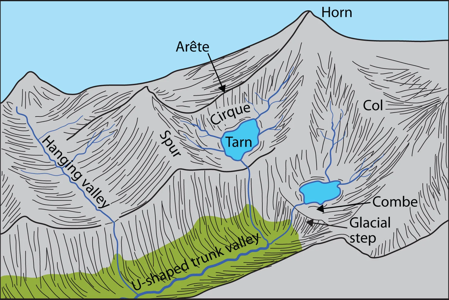
In the context of physical geography, ‘Cirque, Arete, Truncated Spurs, and Moraine’ are the landforms associated with :
Correct
Ans: D
Exp: “Cirque, Arete, Spurs, and Moraine” are landforms associated with glacial landscapes. The movement of glaciers is slow, unlike water flow. Glaciers move basically because of the force of gravity.
Cirques are the most common landforms in glaciated mountains and are found at the heads of glacial valleys. A lake of water can be seen quite often within the cirques after the glacier disappears. Such lakes are called cirque or tarn lakes
Arete is a narrow, sharp ridge that separates two cirques, or glacial valleys. It forms when two glaciers erode parallel valleys on opposite sides of a mountain or ridge. As the glaciers erode the rock, they leave behind a sharp crest that can be quite dramatic and steep.
Truncated Spurs are elongated ridges that extend outward from the sides of a glacial valley. They are formed when the glacier erodes the sides of the valley, leaving behind triangular-shaped landforms that jut out into the valley. The faces of divides or spurs of such hanging valleys opening into main glacial valleys are quite often truncated to give them an appearance like triangular facets
Moraines are long ridges of glacial till. Terminal moraines are long ridges of debris deposited at the end (toe) of the glaciers. Lateral moraines form along the sides, parallel to the glacial valleys.
Incorrect
Ans: D
Exp: “Cirque, Arete, Spurs, and Moraine” are landforms associated with glacial landscapes. The movement of glaciers is slow, unlike water flow. Glaciers move basically because of the force of gravity.
Cirques are the most common landforms in glaciated mountains and are found at the heads of glacial valleys. A lake of water can be seen quite often within the cirques after the glacier disappears. Such lakes are called cirque or tarn lakes
Arete is a narrow, sharp ridge that separates two cirques, or glacial valleys. It forms when two glaciers erode parallel valleys on opposite sides of a mountain or ridge. As the glaciers erode the rock, they leave behind a sharp crest that can be quite dramatic and steep.
Truncated Spurs are elongated ridges that extend outward from the sides of a glacial valley. They are formed when the glacier erodes the sides of the valley, leaving behind triangular-shaped landforms that jut out into the valley. The faces of divides or spurs of such hanging valleys opening into main glacial valleys are quite often truncated to give them an appearance like triangular facets
Moraines are long ridges of glacial till. Terminal moraines are long ridges of debris deposited at the end (toe) of the glaciers. Lateral moraines form along the sides, parallel to the glacial valleys.
Question 5 of 5
5. Question
2 points
With reference to coastal landforms, consider the following statement?
High rocky coasts are smooth with lagoons and tidal creeks, where depositional features dominate.
Low sedimentary coasts have highly irregular coastlines with extensions of water into land where erosional features dominate.
The west coast of India is a high, rocky, retreating coast, and the east coast of India is a low, sedimentary coast.
How many of the statements given above are correct?
Correct
Ans: A
Exp:
Statement 1 is incorrect: Along the high, rocky coasts, the rivers appear to have been drowned by a highly irregular coastline. The coastline appears highly indented, with an extension of water into the land where glacial valleys (fjords) are present. The hillsides drop off sharply into the water. Shores do not show any depositional landforms initially. Erosional features dominate
Statement 2 is incorrect: Along low sedimentary coasts, the rivers appear to extend their length by building coastal plains and deltas. The coastline appears smooth, with occasional incursions of water in the form of lagoons and tidal creeks. The land slopes gently into the water. Marshes and swamps may abound along the coast. Depositional features dominate
Statement 3 is correct:The west coast of our country is a high, rocky, retreating coast, and Erosional forms dominate the west coast. The east coast of India is a low sedimentary coast, and Depositional forms dominate on the east coast.
Incorrect
Ans: A
Exp:
Statement 1 is incorrect: Along the high, rocky coasts, the rivers appear to have been drowned by a highly irregular coastline. The coastline appears highly indented, with an extension of water into the land where glacial valleys (fjords) are present. The hillsides drop off sharply into the water. Shores do not show any depositional landforms initially. Erosional features dominate
Statement 2 is incorrect: Along low sedimentary coasts, the rivers appear to extend their length by building coastal plains and deltas. The coastline appears smooth, with occasional incursions of water in the form of lagoons and tidal creeks. The land slopes gently into the water. Marshes and swamps may abound along the coast. Depositional features dominate
Statement 3 is correct:The west coast of our country is a high, rocky, retreating coast, and Erosional forms dominate the west coast. The east coast of India is a low sedimentary coast, and Depositional forms dominate on the east coast.
Fill The Required Details To Get Early Access Of Quality Content.
(Promise! We Will Not Spam You.)
Quick Revise Now !
AVAILABLE FOR DOWNLOAD SOON
UDAAN PRELIMS WALLAH
Comprehensive coverage with a concise format Integration of PYQ within the booklet Designed as per recent trends of Prelims questions हिंदी में भी उपलब्ध
Quick Revise Now ! UDAAN PRELIMS WALLAH
Comprehensive coverage with a concise format Integration of PYQ within the booklet Designed as per recent trends of Prelims questions हिंदी में भी उपलब्ध
<div class="new-fform">
</div>
Subscribe our Newsletter
Sign up now for our exclusive newsletter and be the first to know about our latest Initiatives, Quality Content, and much more.


 Current Affairs


 GS Foundation
 Optional Course
 Combo Courses
 Degree Program


 February 13, 2024