Udaan, Prahaar, Q&A Bank etc.
CA Magazines & Editorials
Indira Point, located on Great Nicobar Island in the Andaman and Nicobar Islands, is India’s southernmost point with major geo-strategic value near the Malacca Strait. Its role in maritime surveillance, EEZ monitoring, Indo-Pacific security, and lessons from the 2004 tsunami make it highly relevant for UPSC Geography, IR, and Disaster Management.

Indira Point is the southernmost point of India, situated on Great Nicobar Island in the Andaman and Nicobar Islands. It lies close to the Malacca Strait, one of the busiest maritime trade routes in the world, giving it immense strategic significance for India’s maritime security and Indo-Pacific presence. The 2004 Indian Ocean tsunami caused land subsidence here, altering its geography and infrastructure.
This topic is relevant for UPSC IAS exams, covering General Studies Paper I (Geography), Paper II (International Relations), Paper III (Internal Security & Disaster Management), and Prelims.
Indira Point is not just a geographic extremity but a critical strategic location.
Indira Point, located on Great Nicobar Island in the Andaman and Nicobar Islands, is the southernmost point of India. It holds strategic maritime importance near the Malacca Strait and serves as a key point for national security and monitoring.
| Indira Point Overview | |
| Feature | Details |
| Location | Great Nicobar Island, Andaman & Nicobar Islands |
| Coordinates | 6°45′10″N 93°49′36″E |
| State/UT | Andaman and Nicobar Islands |
| Strategic Importance | Maritime surveillance, EEZ monitoring, Indo-Pacific presence |
| Nearest International Route | Malacca Strait |
Explore UPSC Foundation Courses

Explore UPSC Foundation Courses

All the important points regarding the location of Indira Point are provided below.
The history of Indira Point highlights its geographical, strategic, and national importance.
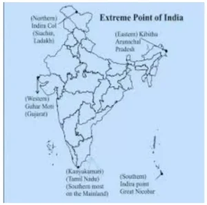
India’s extreme points mark its geographic boundaries from north to south and east to west. These locations hold strategic, cultural, and security significance. Check the table below for details on the southernmost, northernmost, easternmost, and westernmost points.
| Important Extreme Points of India | |||
| Extreme Point | Location | Significance | State/UT |
| Indira Point | Southernmost | Maritime monitoring, Indo-Pacific strategic significance | Andaman & Nicobar |
| Kibithu | Easternmost inhabited | Border surveillance | Arunachal Pradesh |
| Guhar Moti | Westernmost village | Trade & border monitoring | Gujarat |
| Siachen Glacier / Indira Col | Northernmost region | Military strategic | Jammu & Kashmir |
The Indira Point importance lies in both geography and security:
Explore Prarambh Course

Explore Prarambh Course

The strategic importance of Indira Point lies in its role in India’s maritime security and regional influence. It serves as a key monitoring point for naval operations, shipping lanes, disaster management, and Exclusive Economic Zone oversight. Check below for all the important aspects of its strategic significance.
| Strategic Importance of Indira Point | |
| Aspect | Significance |
| Maritime surveillance | Monitors shipping lanes and maritime traffic |
| Proximity to Malacca Strait | Key for international trade oversight |
| Naval importance | Supports Indian Navy operations |
| Indo-Pacific significance | Enhances regional influence |
| Disaster management relevance | Lessons from 2004 tsunami |
| EEZ monitoring | Secures India’s Exclusive Economic Zone |
Understanding the difference between Indira Point and Kanyakumari is important for geography and strategic studies.
Indira Point:
Explore UPSC Optional Courses

Explore UPSC Optional Courses

Kanyakumari:
Strategic Difference:
The 2004 Indian Ocean tsunami had a profound effect on Indira Point, altering its geography and highlighting the need for disaster preparedness. Key impacts include:
Land Subsidence:
Impact on Lighthouse:
Geographical Changes:
Disaster Management Lessons:
Check Out UPSC CSE Books
Visit PW Store
Explore SRIJAN Courses


Explore UPSC Foundation Batches

Connect with our experts to get free counselling & start preparing
Join India’s trusted platform for expert guidance, quality content, proven success.
Learn anytime, anywhere.


India's leading UPSC coaching platform helping aspirants prepare for IAS, IPS, IFS and other Civil Services examinations with the best faculty and proven strategies.
<div class="new-fform">
</div>