Win up to 100% Scholarship

Register Now

Climate of India: Type, Zones, Map, and Factors Influencing Indian Climate

PWOnlyIAS February 24, 2024 03:27 896 0

Climate of India: Indian climate and weather is unique, making it a fascinating topic for study. In recent times, India’s climate is witnessing changes due to anthropogenic causes.

Climate of India: Type, Zones, Map, and Factors Influencing Indian Climate

Context

Climate of India: Indian climate and weather is unique, making it a fascinating topic for study. In recent times, India’s climate is witnessing changes due to anthropogenic causes.

What Is the Monsoon Type of Climate? – Climate of India

Monsoon type of climate is a climatic type that is caused due to the onset of monsoonal winds. This type of climate is based on distinct seasons and the reversal of monsoon winds.

  • Monsoon type of climate is found commonly in Africa, Asia, South America and Central America
  • Apart from these regions, the climate is also found in the Caribbean, North Australia and North America.

Why Does India Have a Monsoon Type of Climate?

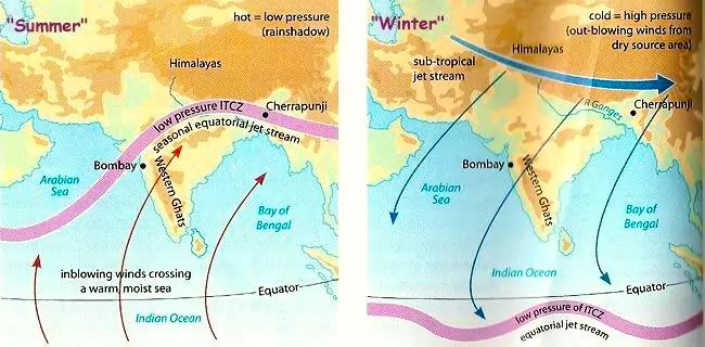
Monsoon Winds: India experiences monsoon type of climate because the country’s climate is influenced by the monsoon winds or the changing weather conditions. This condition occurs as a result of differential heating of land and water bodies and pressure situations.

  • Importance of Monsoon Type of Climate: The monsoon season begins in July and ends in September. 
    • About 80 to 90 percent of the country’s rainfall occurs because of the monsoon.
  • Occurrence: In India’s monsoon climate, the summer monsoon causes heavy rain due to blowing of monsoonal winds from sea to land. 
    • However, the winter monsoon does not cause much rain in the country as the monsoon winds blow from the interior of the continents to the sea. 

What Are Monsoons?

Monsoons are seasonal winds that reverse their direction based on the change in season. The monsoons are responsible for bringing rainfall in the Indian subcontinent. Monsoon in India can be divided into two types: Southwest Monsoon and Northeast Monsoon.

  • Southwest Monsoon: Southwest Monsoon is responsible for bringing heavy rainfall to the majority of India and is caused mainly due to extreme heat on the Tibetan Plateau in the summer season
  • Northeast Monsoon: Northeast monsoon has its origin due to high amounts of pressure over the Siberian and the Tibetan Plateaus during the winter season. They bring rains to the Southeast coast of India.

Factors Causing Indian Monsoon

  • The shift in the position of the Inter-Tropical Convergence Zone (ITCZ): The Inter-tropical Convergence Zone (ITCZ) is a low-pressure belt that is caused due to convergence of north-east trade winds and south-east trade winds.
    • Due to the movement of the Sun towards the Tropic of Cancer, the ITCZ shifts northwards over the Gangetic plain. This is called the Monsoon trough.
    • This low-pressure region attracts south-east trade winds of the southern hemisphere to cross the equator, subsequently changing their direction due to the Coriolis force and start blowing from southwest to northeast.
  • The heating of Tibetan plateau: The Tibetan plateau is warmed during the summer months, due to which an area of low pressure is created. 
    • This belt of low pressure attracts winds from the ocean, which bring in moisture from the oceans, thus initiating the monsoon.
  • The Presence of the Low and High-pressure Area: The presence of the high-pressure area, east of Madagascar, affects monsoon winds. The intensity and position of this high-pressure area strengthens the Indian Monsoon.
  • Tropical Easterly and Westerly Jet Stream: The location of the Easterly and westerly Jet Stream has the potential to influence the pattern of monsoon rainfall. Shifting its position can cause variation of monsoon activity over India.

Climate of India

Importance of Monsoon for India

  • Agriculture: Majority of India’s agriculture is based on rainfall. The majority of rainfall is obtained through monsoons and is thus important.
  • Drinking Water: Rainfall obtained through monsoon is responsible for replenishing drinking water sources of India.
  • Energy Generation: In the peninsular part of India, monsoon rains revitalise rivers and make energy generation possible to cater to demands.
  • Economic Stress: Deficient or variable monsoon is sure to cause economic stress in the country as India is excessively dependent on agriculture.


El Nino:

  • About: El Nino is the unusual warming of the ocean water near the eastern part of the tropical Pacific Ocean, along the coast of Peru and Ecuador.
  • Effects: Warming of ocean water causes unusually higher rainfall in Peru, Ecuador, the United States and the Gulf of Mexico, whereas drought conditions prevail in Australia, India, southern Africa
  • Occurrence: Studies have shown that the El Nino cycle occurs every two to seven years, with its impact visible on Indian Monsoon.

La Nina:

  • About: La Nina is the unusual warming of the ocean water near the Western part of the tropical Pacific Ocean, along the coast of Australia.
  • Effects: La Nina is associated with heavy rains over southeastern Africa and northern Brazil, while there are droughts over tropical South America, Gulf of Mexico and Pampas region.
  • Occurrence: La Nina events usually occur every 3 to 5 years, but on occasion can occur over successive years. It is observed that La Nina strengthens Monsoonal rains in India. 

Madden-Julian Oscillation (MJO):

  • About: Madden-Julian Oscillation (MJO) is an ocean-atmospheric traversing phenomenon that affects weather activities across the globe by bringing fluctuation in tropical weather on a weekly to monthly basis.
  • Feature: It can be roughly defined as an eastward moving ‘pulse‘ of clouds, rainfall, winds and pressure that usually recurs every 30 to 60 days, near the equator.
  • Impact on India: When MJO passes over the Indian Ocean during the Monsoon season, it brings sufficient rainfall over the Indian subcontinent. 
    • However, when MJO witnesses a longer cycle and stays over the Pacific Ocean, the Indian monsoon is negatively impacted

Indian Ocean Dipole:

  • About: Indian Ocean Dipole is a phenomenon that occurs in the Indian Ocean between the Indonesian and Malaysian coastline in the east and the African coastline near Somalia in the west.
  • Phases of IOD: There are two phases of IOD: the positive phase and negative phase.
    • Positive Phase: During the positive phase, the western part of the Indian Ocean, near the Africa coast, becomes warmer compared to the eastern Indian Ocean.
    • Negative Phase: During the negative phase, the western Indian Ocean becomes cooler.
  • Impact: During positive IOD, there is heavy rainfall over African coastline and also over the Indian sub-continent while bringing lower rainfall over Indonesia, southeast Asia and Australia

Agro-Climatic Zones of India 

Agro-climatic zone refers to a land unit in terms of major climates, suitable for a certain range of crops and cultivars. 

Climate of India

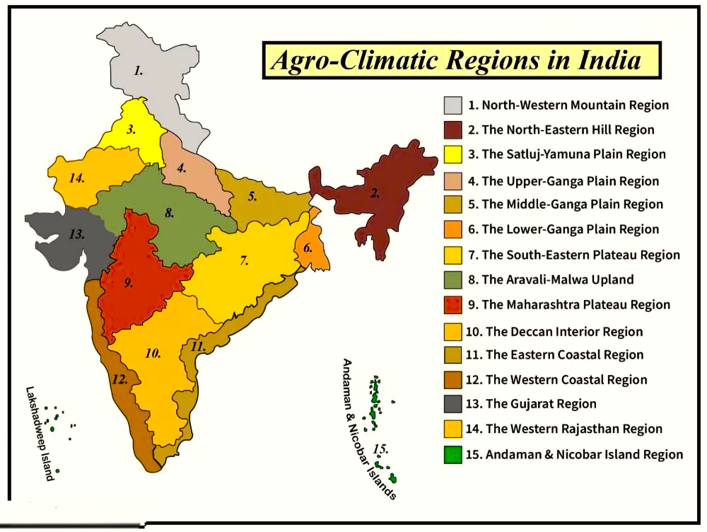
Map: Agro-Climatic Zones of India 

  • Importance: This classification has to be referred to while considering food, fiber, fodder and fuel wood without adversely affecting the environment and natural resources.
  • Basis of Classification: The classification of agro-climatic zones considers the soil types, rainfall, temperature and water availability which influence the type of vegetation.
  • Division of Agro-climatic Zones: The seventh Planning Commission has divided the country into fifteen broad agro-climatic zones based on physiography, soils, geological formation, Climate, cropping patterns, and mineral resources.
  • Out of the fifteen, fourteen regions are in the mainland and the remaining one in the islands of Bay of Bengal and the Arabian Sea.
    • Western Himalayan Region (Zone 1): The regions of Jammu and Kashmir, Himachal Pradesh and Kumaun-Garhwal areas of Uttarakhand are covered under this zone.
      • The average annual rainfall is 150 cm. The temperature ranges from 0°C to -4°C. The soil consists of both valley alluvium and brown hilly soils. 
    • Eastern Himalayan Region (Zone 2): The areas of Sikkim, Darjeeling (West Bengal), Arunachal Pradesh, Assam hills, Nagaland, Meghalaya, Manipur, Mizoram and Tripura come under this zone.
      • Due to its rugged topography, the region receives rainfall over 200 cm and temperature ranges between 11°C to 33°C.
    • Lower Gangetic Plains Region (Zone 3): The regions of eastern Bihar, West Bengal and Assam valley are covered under this zone.
      • Annual precipitation ranges between 100 cm-200 cm. The annual temperature ranges between 9°C to 41°C.
    • Middle Gangetic Plains Region (Zone 4): The region covers eastern Uttar Pradesh and Bihar and comprises fertile alluvial plain drained by the Ganga River and its tributaries.
      • The annual rainfall ranges between 100 cm and 200 cm while the annual temperature ranges from 9°C to 41°C.
    • Upper Gangetic Plains Region (Zone 5): The central and western parts of Uttar Pradesh is covered under this zone.
      • Annual temperature ranges from 7°C to 41 °C. The average rainfall is between 75 cm- 150 cm.  sandy and loamy soil can be found here.
    • Trans-Gangetic Plains Region (Zone 6): Punjab, Haryana, Delhi, Chandigarh and Ganganagar district of Rajasthan are covered in this zone.
      • The average temperature ranges between 7°C to 42°C and average annual rainfall ranges between 70 cm and 125 cm. 
    • Eastern Plateau and Hills Region (Zone 7): This zone covers the areas of Chotanagpur plateau, Rajmahal Hills, Chhattisgarh plains and Dandakaranya.
      • An average of 80 cm-150 cm of annual rainfall can be witnessed. 
      • Temperature ranges from 10°C to 35°C. Red, yellow, laterites and alluvium are found in abundance.
    • Central Plateau and Hills Region (Zone 8): Bundelkhand, Baghelkhand, Bhander plateau, Malwa plateau and Vindhyachal hills are covered under this zone.
      • The zone witnesses average annual rainfall from 50 cm- 100 cm. The annual temperature ranges from 7°C to 40°C. The soil type is a mixture of red, yellow and black.
    • Western Plateau and Hills Region (Zone 9): This agro-climatic zone encompasses southern part of the Malwa plateau and Deccan plateau (Maharashtra). 
      • The region witnesses annual rainfall of 25 cm-75 cm and an annual temperature range of 6°C to 41°C.
    • Southern Plateau and Hills Region (Zone 10): This zone encompasses the regions of southern Maharashtra, Karnataka, western Andhra Pradesh and northern Tamil Nadu
      • The area witnesses annual rainfall between 50 cm-100 cm and an average temperature of 13°C to 42°C.
    • East Coast Plains and Hills Region (Zone 11): This zone covers Coromandel and Northern Circars in the eastern part of the Indian coastline. 
      • The climate is sub-humid maritime with average temperatures ranging from 20°C-35°C and annual rainfall of 75 cm-150 cm. 
      • Alluvial, loam and clay soils are commonly found here. 
    • West Coast Plains and Ghats Region (Zone 12): This zone extends over Malabar, Konkan coasts and the Sahyadri mountain ranges.
      • The region comprises laterite and coastal alluvial soil. The annual rainfall is above 200 cm and average temperatures range from 19°C to 36°C. 
    • Gujarat Plains and Hills Region (Zone 13): This region covers Kathiawar and valleys of the Mahi and Sabarmati rivers.
      • It consists of arid and semi-arid regions with average annual rainfall between 50 cm-100 cm, and temperatures between 13°C to 42°C. 
      • The soils in this zone are regur in the plateau region, alluvium in the coastal plains and red and yellow soils in Jamnagar area.
    • Western Dry Region (Zone 14): This zone covers western part of Rajasthan, which is west of the Aravallis. 
      • It is characterised by hot sandy desert, erratic rainfall, high evaporation, and absence of perennial rivers.
      • Cultivable crops are mainly arid crops, which can survive harsh climates and low water availability. 
    • The Islands Region (Zone 15): It covers the regions of Andaman-Nicobar and Lakshadweep which typically have equatorial climates.
      • The annual rainfall is below 300 cm, the mean temperatures being between 30°C and 25°C.
      • The soils in these regions vary from sandy along the coast to clayey loam in valleys and lower slopes.

Factors Affecting the Climate of India

  • Factors based on location and relief
    • Latitude: The region lying south of the Tropic of Cancer lies in the Tropical zone while the northern part of India lies in the sub-tropical and temperate zone.
      • Due to its proximity to the equator, the tropical zone experiences high temperatures throughout the year with a small daily and annual range.
    • Altitude: Places at high altitude are cooler than the places on the plains as temperature decreases with increase in height.
    • Relief Features: Relief features such as mountains affect the climate drastically. 
      • Places on the windward side receive high rainfall while those on the leeward side receive very low rainfall.
    • Sea and Land Distribution: Due to India’s peninsular nature, differential heating of water creates different air pressure zones in different seasons in and around the subcontinent.
    • Distance from Sea: Proximity to sea reduces extreme temperatures. Increase in distance from sea increases causes extreme weather conditions. 
  • Factors based on air pressure and winds that affecting the Climate of India
    • Air Pressure: The distribution of air pressure and winds on the surface of the earth causes changes in climate.
    • Air Circulation: Upper air circulation affects global weather and the inflow of different air masses and jet streams.
    • Disturbances: Western disturbances during the winter season and tropical depression during the southwest monsoon causes rainfall.

What Are the Climatic Zones of India? – Climate Map of India 

Climate of India

  • Hot and Dry Climate: Regions under this climate lie in western part of the country. Regions of Maharashtra, Rajasthan, Karnataka, Gujarat, and western Madhya Pradesh come under this climatic zone.
    • Rainfall in this zone is very low, with cloudless sky. Winters are cold and summers are hot and dry. There is very little vegetation cover.
  • Warm and Humid Climate: This climatic zone lies in the southern and eastern part of the country. 
    • These areas lie along the coastal belt, encompassing the states of Gujarat, Maharashtra, Karnataka, Goa, Kerala, Tamil Nadu, Andhra Pradesh, Odisha, West Bengal etc.
    • Humidity is very high and rainfall is high due to the long monsoon season. 
    • There is very low variation of weather throughout the year.
  • Composite Climate: Composite zone mainly lies in the central part of the country. Normal climate is neither extremely hot and dry nor warm and humid.
    • The region experiences hot and dry weather during summer, strong monsoon and chilly winters.
  • Cold Climate: This climatic zone mainly lies in the northern and eastern part of the country. Some regions in the climatic zone include Ladakh, Jammu and Kashmir, Himachal Pradesh, Uttarakhand, Arunachal Pradesh etc.
    • Sky is usually clear and cloudless. There is variable precipitation. Vegetation is usually green and the region experiences cold conditions.
  • Moderate Climate: Moderate climatic zone lies in small pockets of South India. The region is known for warm summers and cool winters.
    • Precipitation is average, which is distributed throughout the year. This zone usually lies in plateau or high plateau region. 

Types of Climates in India: Koppen’s Classification

Code of Climate  Type of Climate Regions under the Climate
Aw Tropical Savanna  India’s peninsular plateaus, south of the Tropic of Cancer.
Amw Tropical monsoon with short dry season India’s west coast, south of Goa.
As Tropical moist Coromandel coast of India.
BShw Semi-Arid steppe Gujarat’s north-west, parts of Rajasthan and Punjab.
Bwhw  Hot desert Western Rajasthan.
Cwg Monsoon with dry winters Gangetic plain, eastern part of Rajasthan, northern Madhya Pradesh, north-east India.
Dfc Cold humid winter with short summer  Arunachal Pradesh
E Polar Type Jammu and Kashmir, Uttarakhand, Himachal Pradesh.
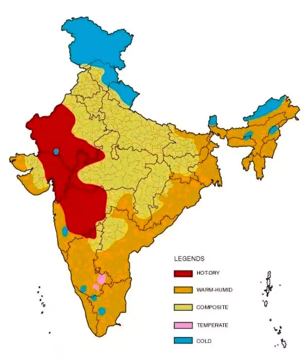
 

Koppen’s Climate Classification

Koppen classification is a type of climate classification based on mean monthly temperature, the mean monthly rainfall and the mean annual rainfall.

  • Koppen classification divides terrestrial climates into five major types, which are denoted by the capital letters A, B, C, D, and E.
  • Each of the climate types is subdivided into subtypes, denoted by small alphabets such as h, g, c, f, w etc.
    • A (Tropical): The region experiences monthly temperature throughout the year of over 18°C.
    • B (Arid): This region has low precipitation. If the climate is semi-arid, it is designated as “ S ” and if it is more, the climate is arid designated as “ W ”.
    • C (Temperature): This region experiences a mean temperature between 18°C and minus 3°C in the coldest month.
    • D (Continental): In this type, a region’s mean temperature of the warmest month is over 10°C and the mean temperature of the coldest month is under minus 3°C
    • E (Polar): It refers to a region whose mean temperature of the warmest month is under 10°C.  

Conclusion

India is a unique country, which experiences a variety of climatic conditions, ranging from dry to ice cold. These climatic conditions are responsible for influencing India’s traditions, attire, food, festivals, economy, consumption etc.

Also Read: Indian Climate NCRT- PWOnlyIAS


Must Read
NCERT Notes For UPSC UPSC Daily Current Affairs
UPSC Blogs UPSC Daily Editorials
Daily Current Affairs Quiz Daily Main Answer Writing
UPSC Mains Previous Year Papers UPSC Test Series 2024


Frequently Asked Questions

Monsoon type of climate is a climatic type that comes under the influence of the monsoonal winds.

India experiences a monsoon type of climate because the country’s climate is influenced by the monsoon winds or the changing weather conditions.

Monsoons are seasonal winds that reverse their direction based on the change in season. The monsoons are responsible for bringing rainfall in the Indian subcontinent.

Koppen classification is a type of climate classification based on mean monthly temperature, the mean monthly rainfall and the mean annual rainfall. Koppen classification divides terrestrial climates into five major types, which are denoted by the capital letters A, B, C, D, and E.

Agro-climatic zone refers to a land unit in terms of major climates, suitable for a certain range of crops and cultivars. The classification of agro-climatic zones considers the soil types, rainfall, temperature and water availability which influence the type of vegetation.

There are 15 types of Agro-climTIC zones in India. Major among them include Western Himalayan Region, Trans gangetic Plains Region, East Coast Plains and Hills Region, Western Dry Region etc.

There are many factors ranging from latitude, altitude, distance from sea, air pressure, air circulation etc that affect India’s climate.

India experiences a monsoon type of climate, which is a type of climate that is influenced by the monsoon winds or the changing weather conditions.

Archive Calendar

Mon Tue Wed Thu Fri Sat Sun
 12345
6789101112
13141516171819
20212223242526
2728293031  

by month

 Final Result – CIVIL SERVICES EXAMINATION, 2023.   Udaan-Prelims Wallah ( Static ) booklets 2024 released both in english and hindi : Download from Here!     Download UPSC Mains 2023 Question Papers PDF  Free Initiative links -1) Download Prahaar 3.0 for Mains Current Affairs PDF both in English and Hindi 2) Daily Main Answer Writing  , 3) Daily Current Affairs , Editorial Analysis and quiz ,  4) PDF Downloads  UPSC Prelims 2023 Trend Analysis cut-off and answer key

THE MOST
LEARNING PLATFORM

Learn From India's Best Faculty


 Final Result – CIVIL SERVICES EXAMINATION, 2023.   Udaan-Prelims Wallah ( Static ) booklets 2024 released both in english and hindi : Download from Here!     Download UPSC Mains 2023 Question Papers PDF  Free Initiative links -1) Download Prahaar 3.0 for Mains Current Affairs PDF both in English and Hindi 2) Daily Main Answer Writing  , 3) Daily Current Affairs , Editorial Analysis and quiz ,  4) PDF Downloads  UPSC Prelims 2023 Trend Analysis cut-off and answer key

Quick Revise Now !
AVAILABLE FOR DOWNLOAD SOON
UDAAN PRELIMS WALLAH
Comprehensive coverage with a concise format
Integration of PYQ within the booklet
Designed as per recent trends of Prelims questions
हिंदी में भी उपलब्ध
Quick Revise Now !
UDAAN PRELIMS WALLAH
Comprehensive coverage with a concise format
Integration of PYQ within the booklet
Designed as per recent trends of Prelims questions
हिंदी में भी उपलब्ध

<div class="new-fform">


    </div>

    Subscribe our Newsletter
    Sign up now for our exclusive newsletter and be the first to know about our latest Initiatives, Quality Content, and much more.
    *Promise! We won't spam you.
    Yes! I want to Subscribe.