Jan 09 2025

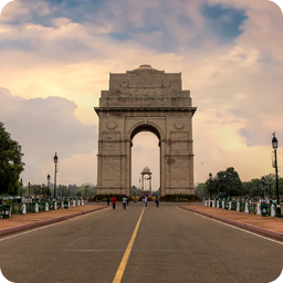
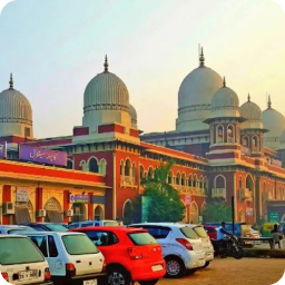
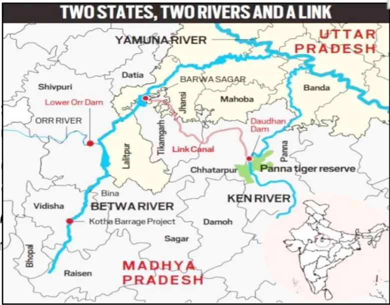
The Prime Minister of India launched the Ken-Betwa River Link Project on the 100th birth anniversary of former Prime Minister Atal Bihari Vajpayee.

About Ken-Betwa Project

Interlinking of Rivers

  • The Ken-Betwa Project is a river interlinking initiative designed to transfer surplus water from the Ken River in Madhya Pradesh to the Betwa River in Uttar Pradesh.
  • The Union Cabinet had approved Rs 44,605 crore for the KBLP project in December 2021.
  • A Special Purpose Vehicle (SPV), the Ken-Betwa Link Project Authority (KBLPA), will oversee the implementation of the project.
  • Link Canal Length: 221 km in length, including a 2-km tunnel.
  • The Ken-Betwa Link Project has two phases. 
    • Phase I will involve building the Daudhan Dam complex and its subsidiary units such as the Low-Level Tunnel, High-Level Tunnel, Ken-Betwa Link Canal, and powerhouses. 
    • Phase II will involve three componentsLower Orr Dam, Bina Complex Project, and Kotha Barrage.
  • Benefits:
    • Irrigation: The project aims to provide irrigation to Bundelkhand, one of India’s most drought-affected regions.
      • According to the Jal Shakti Ministry, the project is expected to provide annual irrigation to 10.62 lakh hectares (8.11 lakh ha in MP and 2.51 lakh ha in UP) of land, supply drinking water to about 62 lakh people
    • Power Generation: The project is also aimed at generating more than 103 MW of hydropower and 27 MW of solar energy. 

Enroll now for UPSC Online Course

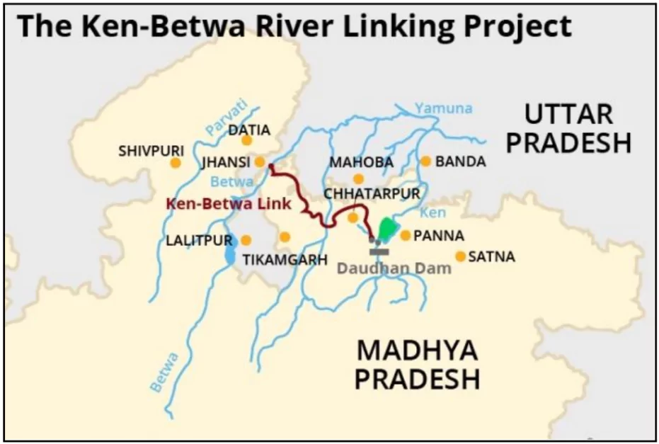
About Ken and Betwa Rivers

Interlinking of Rivers

  • Origin: Both rivers originate in Madhya Pradesh.
    • The Ken River starts from the north-west slopes of the Kaimur Range in Jabalpur, Madhya Pradesh, and meets the Yamuna River in Uttar Pradesh’s Banda district.
    • The Betwa River originates in the Vindhya Range near Hoshangabad, Madhya Pradesh, flows through Bundelkhand, and joins the Yamuna River at Hamirpur, Uttar Pradesh.
  • Tributaries: Both rivers are tributaries of the Yamuna River.
  • Dams on Betwa River: Rajghat, Paricha, and Matatila dams are located on the Betwa River.
  • Ken River passes through the Panna Tiger Reserve.

About River Linking Projects

  • River linking projects involve the construction of canals and dams to transfer water from water-surplus river basins to water-deficient basins. 
    • This is often done to address water scarcity, improve irrigation, and generate hydropower.
  • Examples: 
    • The Volga-Don Canal in Russia: Connecting the Caspian and Black Seas, this canal facilitates navigation and water transfer between the two major river basins.

Historical Background

Interlinking of Rivers

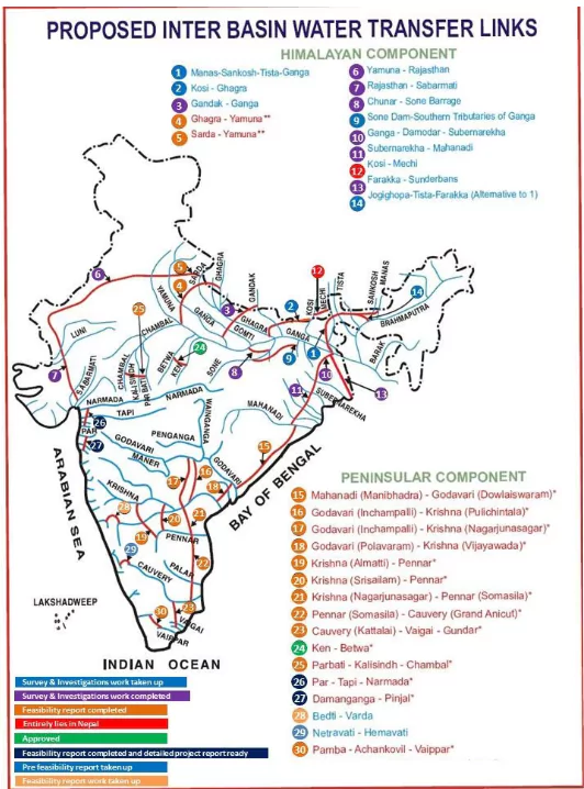
The concept of river interlinking was first proposed by Sir Arthur Cotton 130 years ago; designed irrigation dams in the Godavari and Krishna river valleys.

  • 1972: Dr. K.L. Rao suggested the National Water Grid linking Ganga and Cauvery rivers but was criticized for high costs.
  • 1977: Captain Dastur proposed the Garland Canal to connect Himalayan and Peninsular rivers but faced technical challenges.
  • 1980: National Perspective Plan (NPP) launched, identifying 30 river links (14 Himalayan, 16 Peninsular) for water transfer.
  • 1982: National Water Development Agency (NWDA) established to conduct feasibility studies.
  • 2002: Supreme Court, via a PIL, directed the government to expedite interlinking projects.

About National Perspective Plan (NPP)

  • The Government of India formulated the National Perspective Plan (NPP) for interlinking rivers in 1980.
  • The National Water Development Agency (NWDA) is responsible for executing the interlinking of rivers under the NPP.
  • The NPP consists of two components:
    • Himalayan Rivers Development Component.
    • Peninsular Rivers Development Component.
  • A total of 30 link projects have been identified under the NPP.
    • 14 Himalayan and 16 Peninsular links.
  • The Ken-Betwa Link Project (KBLP) is the first interlinking of rivers project under the NPP and is currently under implementation.

Check Out UPSC CSE Books From PW Store

About National Water Development Agency (NWDA)

  • The NWDA is a registered society under the Department of Water Resources, River Development & Ganga Rejuvenation (DoWR, RD&GR), Ministry of Jal Shakti (MoJS).
  • It was established in 1982 under the Societies Registration Act of 1860 to conduct detailed studies, surveys, and investigations related to the National Perspective Plan (NPP) for Water Resources Development.
  • One of its key functions is to undertake, construct, repair, renovate, rehabilitate, and implement projects under the Pradhan Mantri Krishi Sinchayee Yojana (PMKSY).

Why River Interlinking is Needed in India?

  • Water Scarcity: A report titled “Composite Water Management Index (CWMI)”, published by NITI Aayog in June 2018, mentioned that nearly 600 million people were facing high to extreme water stress.
    • Interlinking can transfer surplus water from rivers like Brahmaputra to drought-prone areas like Rajasthan and Bundelkhand.
  • Uneven Water Distribution: 80% of India’s water flows occur during the monsoon, leading to floods in some regions and droughts in others.
    • Ganga and Brahmaputra basins experience floods, while Peninsular rivers face water shortages.
  • Agricultural Needs: India’s agriculture depends on monsoon rains, which are irregular and unpredictable.
    • Interlinking projects can irrigate 35 million hectares of additional land, increasing food security.
  • Flood and Drought Management: The economic loss of the floods is estimated to be in the range of Rs 10,000-15,000 crore, as per SBI’s research report, Ecowrap.
    • Diverting excess water to water-scarce regions helps mitigate these extremes.
  • Urban and Industrial Water Demand: Rapid urbanization and industrial growth have escalated water demand.
    • Projects like Damanganga-Pinjal Link aim to supply water to cities like Mumbai.
  • Hydropower Potential: India has untapped hydropower potential; ILR can generate 34,000 MW of clean energy.
  • Regional Disparities: Resolves water disputes between states by providing equitable water distribution.
    • For example, linking rivers in Tamil Nadu and Karnataka to address Cauvery disputes.
  • Climate Change Resilience: Erratic rainfall due to climate change affects water resources.
    • Interlinking provides a buffer by redistributing water resources across regions.

Benefits of River Interlinking Projects (ILR)

  • Improved Irrigation Facilities: ILR aims to irrigate drought-prone areas by transferring surplus water.
    • Ken-Betwa Link will provide irrigation to 1.07 million hectares in Bundelkhand, improving agricultural productivity.
  • Enhanced Water Supply: Ensures consistent water availability for drinking, industrial, and agricultural use.
    • The Damanganga-Pinjal Link is designed to provide drinking water to Mumbai, addressing urban water shortages.
  • Flood Control: ILR redistributes excess water from flood-prone areas to deficit regions, mitigating flood damage.
    • Diverting water from the Brahmaputra basin can reduce floods in Assam while benefiting arid regions in Rajasthan.
  • Hydropower Generation: ILR projects integrate hydroelectric power plants to meet energy demands.
    • The Daudhan Dam (Ken-Betwa project) is expected to generate 103 MW of hydropower.
  • Economic Growth: Reliable water supply supports industries, agriculture, and employment generation.
    • The Polavaram Project in Andhra Pradesh boosts the agricultural economy and attracts industrial investments.
  • Groundwater Recharge: Redistribution of water improves groundwater levels in arid regions, ensuring long-term water sustainability.
    • The Par-Tapi-Narmada Link is expected to enhance groundwater in water-deficient Gujarat.
  • Mitigation of Regional Imbalances: Addressing regional water availability disparities, reducing interstate conflicts.
    • Linking rivers in Tamil Nadu and Karnataka can resolve water-sharing disputes and boost cooperation.
  • Inland Waterways: Linking of rivers has the potential to significantly enhance inland waterways by creating a continuous navigable network across river basins. 

Check Out UPSC NCERT Textbooks From PW Store

Environmental challenges of River Interlinking

  • Loss of Biodiversity: River interlinking disrupts natural ecosystems, threatening aquatic and terrestrial species.
    • Example: The Ken-Betwa Link endangers wildlife in the Panna Tiger Reserve.
  • Common Monsoon Patterns: Most of the rivers typically have surplus water during the monsoon and experience scarcity during the dry season.
    • Example: Ganga, Brahmaputra, and Peninsular rivers like Godavari overflow during the monsoon but face reduced flow in summer.
  • Disruption of Delta Ecosystems: Reduced sediment flow to deltas can lead to salinity intrusion and loss of fertile lands.
    • Example: Indus and Narmada deltas face similar degradation after river diversions.
  • Ecosystem Fragmentation: Interlinking may disrupt natural connectivity between rivers, impacting migratory species and sediment flow critical for ecosystems.
  • Salinity Intrusion: Reduced freshwater flow increases seawater penetration in deltas, degrading land fertility.
    • The Indus Delta faced severe salinity intrusion, land degradation, and loss of fisheries due to reduced freshwater flow from upstream diversions.
  • Pollution and Invasive Species: Inter-basin water transfer spreads pollutants and invasive species, affecting aquatic ecosystems.

Socio-Economic challenges of River Interlinking

  • Displacement of Communities: Large-scale submergence of villages and agricultural land forces thousands to relocate.
    • The Ken-Betwa River Linking Project (KBLP) is expected to displace 6,628 families, with inadequate rehabilitation measures.
  • Loss of Livelihoods: Fishing, agriculture, and allied activities dependent on natural river ecosystems are disrupted.
    • Reduced freshwater flow in deltas affects fishing communities in regions like the Indus Delta.
  • High Financial Burden: Estimated ₹5.5 lakh crore for the National River Linking Project (NRLP), diverting funds from other crucial social welfare projects.

Other Challenges of River Interlinking

  • Inter-State Water Disputes: Redistribution of water can exacerbate conflicts between states over water-sharing rights.
    • Long-standing disputes like Cauvery water conflict highlight potential issues in interlinking projects.
  • Legal and Policy Framework: Lack of a comprehensive central regulatory framework complicates inter-state cooperation and dispute resolution.

Global Examples of Water Diversion Failure:

  • The Kissimmee River in Florida suffered extensive wetland loss due to channelization, requiring costly restoration efforts.
  • The Aral Sea, once a large lake, became a desert after river diversions for Soviet irrigation projects.

Check Out UPSC Modules From PW Store

    • Water-sharing agreements often stall due to differing state priorities, as seen in the Ken-Betwa Project.
  • Climate Change Uncertainty: Erratic rainfall patterns and changing river flow dynamics due to climate change may undermine the reliability of water transfers.
    • Donor rivers like the Brahmaputra may face reduced flow in future decades.
  • Operational Challenges: Maintenance of massive infrastructure, including dams and canals, requires sustained funding and technical expertise.
  • International Implications: Projects involving Himalayan rivers require cooperation with neighboring countries like Nepal and Bhutan, complicating negotiations.
    • Example: India-Nepal cooperation is essential for Himalayan river interlinking projects like the Saptakosi-Sun Kosi Link, but concerns over submergence and benefit-sharing hinder progress.
  • Cultural and Ideological Conflict: The river interlinking project contradicts the religious ideology, which views rivers as sacred entities.

Successful Case Studies of River Interlinking

  • Tennessee Valley Authority (USA): A comprehensive river basin management project that interlinked rivers for navigation, flood control, and hydropower.
    • Successfully revitalized the region’s economy by boosting agriculture, industries, and employment.
  • Mekong River Basin (Southeast Asia): Inter-basin water transfer facilitated agriculture and energy production in Laos, Vietnam, and Cambodia.
    • Created regional cooperation, balancing water-sharing needs among countries.

Way Forward for River Interlinking Projects in India

  • Comprehensive Environmental Impact Assessments (EIA): Conduct detailed EIAs to assess and mitigate ecological damage, biodiversity loss, and salinity intrusion.
    • Ensure implementation of Environmental Management Plans (EMP) and restoration initiatives.
  • Equitable Water Sharing Mechanisms: Develop a robust legal framework to address inter-state disputes and ensure fair distribution of water resources.
    • Establish a central authority under Entry 56 of the Union List of Sch. 7 (Constitution) for streamlined decision-making.
  • Focus on Sustainable Alternatives: Prioritize localized solutions like watershed management, rainwater harvesting, and micro-irrigation to complement river interlinking.
    • Promote high-efficiency irrigation systems such as drip and sprinkler irrigation.
    • Virtual Water Trade (VWT): Reduces the need for extensive interlinking infrastructure by addressing water scarcity through trade.
      • Virtual Water Trade involves importing water-intensive goods from regions with abundant water to conserve water in deficit regions.
  • Improved Rehabilitation and Resettlement (R&R) Policies: Provide adequate compensation, employment opportunities, and social support for displaced communities.
    • Include affected populations in the planning process to address their concerns.
  • Leverage Modern Technology: Use satellite imagery and GIS tools for precise planning and monitoring of river interlinking projects.
    • Implement real-time water flow management systems to ensure efficiency and minimize wastage.
  • Climate Resilience Planning: Incorporate climate change models to predict rainfall variability and ensure long-term viability of water transfers.
    • Avoid over-reliance on perceived “surplus” water in donor rivers.
  • Phased Implementation and Pilot Projects: Begin with smaller, region-specific links to demonstrate viability and learn lessons before scaling up.
    • Accelerate work on priority links like Ken-Betwa and Par-Tapi-Narmada.

Enroll now for UPSC Online Classes

Conclusion

Rivers provide critical ecosystem services, including sediment transport for delta formation, support for biodiversity, enhancement of land fertility, and groundwater recharge. Policymakers must balance technological interventions with environmental sustainability to ensure the long-term ecological and societal health of the nation. River interlinking projects must align with climate change mitigation strategies to avoid irreversible damage to natural systems.

The Union Minister of Ports, Shipping & Waterways, announced major initiatives to boost the capacity at Deendayal Port worth an investment of more than ₹57,000 crores.

Major Announcements

  1.  A new Mega Shipbuilding Project with an investment of ₹30,000 crores and capacity to produce 32 new ships and repair 50 old ships every year
    1. Benefits: Develop technical capability to manufacture big Very Large Crude Carrier (VLCC) or similar class of vessels with capacity up to 3,20,000 tonnes DWT.
    2. Other facilities like  Marina, Fishing Harbour, Townships and Marine Industrial Cluster.
  2. A New Cargo Terminal with investment of ₹27,000 crores which will add an additional 135 MTPA capacity to the Kandla Port.
    1. Benefits: Improve the waiting of Liquid Tanker Vessels and improvement in the Turnaround time of liquid vessels.
    2. Proximity to Kandla Creek  will  reduce the dredging requirement and allowing bigger vessels to dock. 

Enroll now for UPSC Online Classes

About Deendayal Port

  • Location: Kandla Port, officially known as Deendayal Port, is situated on the Gulf of Kutch in Gujarat, India.
  • Strategic Importance: It is one of India’s largest and busiest ports, strategically located to handle cargo from northern and western India.
  • It is an Artificial port established in the 1950s after the partition of India to handle trade and alleviate congestion at the Mumbai port.
    • Renamed Deendayal Port in 2017 in honor of Pandit Deendayal Upadhyaya.
  • Type: A tidal port equipped to handle bulk, liquid, and container cargo.
  • Infrastructure: Includes specialized terminals for various cargo types and a free trade zone to promote international trade.
  • Free Trade Zone (FTZ): Kandla was the first port in India to establish a Special Economic Zone (SEZ), attracting industries and boosting export-oriented activities.

IndiaAI, an independent division under Digital India Corporation, has partnered with Microsoft to enhance the adoption and growth of artificial intelligence (AI) in India. 

  • The collaboration aligns with the IndiaAI Mission’s objectives to empower communities and foster innovation.

Key Highlights of the Partnership

  • Skilling Initiatives
    • Train 500,000 individuals by 2026, including students, educators, developers, government officials, and women entrepreneurs.
  • AI Innovation in Rural Areas
    • IndiaAILaunch AI Catalysts as Centers of Excellence to promote AI development in Tier 2 and Tier 3 cities.
  • AI Productivity Labs
    • Establish labs in 20 National Skill Training Institutes (NSTIs) or NIELIT centers across 10 states.
    • Train 20,000 educators and provide AI courses to 100,000 students in 200 Industrial Training Institutes (ITIs).
  • Development of Indic AI Models
    • Create foundational AI models with Indic language support to cater to India’s linguistic and cultural diversity.
  • Responsible AI Practices
    • Develop frameworks for ethical AI, set evaluation standards, and establish an AI Safety Institute in India.

Check Out UPSC CSE Books From PW Store

What is IndiaAI Mission?

  • The IndiaAI Mission is a government initiative aimed at building a strong ecosystem for artificial intelligence (AI) in India.
  • Launch Date: March 2024
  • It focuses on innovation, accessibility, and responsible development of AI technologies.
  • Ministry: The mission is an umbrella program under the Ministry of Electronics and Information Technology (MeitY).
  • Highlights of the Mission
    • Focus on Inclusivity: Ensures that AI benefits everyone, bridging gaps in accessibility.
    • Strengthening Digital Trust: Develops tools to make AI systems safe, ethical, and secure.
    • Encouraging Collaboration: Involves academic institutions, startups, and industries to innovate together.

Six people died and many were injured in a stampede at Vishnu Nivasam in Tirupati, Andhra Pradesh. The incident occurred during the token distribution for Vaikunta Dwara Sarva Darshan.

About Vaikunta Dwara Sarva Darshan

  • Token Distribution: 120,000 tokens were to be issued for free ‘sarva darshan’ across 94 counters in Tirupati.
  • Vaikunta Dwara Darshanam: A 10-day annual festival starting January 10, allowing special darshan of Lord Venkateswara through the northern entrance.
  • Inadequate crowd management at key locations like Srinivasam led to the incident. 
    • Stampede triggered when a gate was opened to assist a distressed woman.

About Tirumala Venkateswara Temple

  • Location: The Tirumala Venkateswara Temple is situated in Andhra Pradesh, positioned on Venkata Hill, which is one of the seven hills (Saptagiri) of the Tirumala Hills.
  • Dedicated to: The temple is dedicated to Lord Sri Venkateswara, who is considered an incarnation of Lord Vishnu.
  • Tirupati Laddu: The renowned Tirupati Laddu, given as prasad at the temple, holds a Geographical Indication (GI) tag.
  • Historical Significance: The temple has a rich history, with significant contributions from South Indian dynasties, including the Pallavas, Cholas, and Vijayanagara rulers.
    • It was revived in the 12th century by Saint Ramanuja.

Check Out UPSC NCERT Textbooks From PW Store

Architecture of the Temple

Tirumala Venkateswara Temple

  • The temple is constructed in the Dravidian architectural style.
  • Three entrances lead to the sanctum sanctorum, also known as “Ananda Nilayam,” which houses the main deity, Venkateswara, in a standing posture facing east.
  • The temple is enclosed within a compound wall, and the front wall features an entrance gateway called a gopuram.
  • The main temple tower, known as the vimana, has a stepped pyramid shape that rises geometrically.
  • The crowning element at the top of the temple, known as the shikhara, is typically shaped like a small stupika or an octagonal cupola.
  • The temple complex includes two circumambulation (parikrama) paths for devotees.
  • A large temple tank or water reservoir is enclosed within the temple complex, adding to its spiritual and architectural significance.
Additional Reading: Stempede

The Supreme Court noted that the Union government has not fully implemented the Dam Safety Act, 2021, which was enacted nearly five years ago.

  • A three-judge Bench criticized the Act for being “existing on paper,” following Kerala’s argument that no substantial actions, including the constitution of a National Committee on Dam Safety (NCDS), have been taken.

About Dam Safety Act 2021

  • Purpose: The Dam Safety Act, 2021, aims to ensure the proper surveillance, operation, and maintenance of specified dams to prevent dam failures.
  • Obligation of Dam Owners: Dam owners are responsible for the safe construction, operation, maintenance, and supervision of dams.
    • Each dam must have a dam safety unit to inspect:
    • Before and after the monsoon season.
    • During and after earthquakes, floods, calamities, or any signs of distress.

Enroll now for UPSC Online Course

4-Tiered Institutional Mechanism for Dam Safety

  1. National Committee on Dam Safety (NCDS)
    • Constituted by: Central Government.
    • Headed by: Chairman of the Central Water Commission (Ex-officio Chairman).
    • Mandate: Formulates policies and recommends regulations to enhance dam safety standards.
  2. National Dam Safety Authority (NDSA)
    • Constituted by: Central Government.
    • Headed by: An officer not below the rank of Additional Secretary to the Government of India.
    • Mandate: Acts as a regulatory authority to implement policies, guidelines, and standards devised by the NCDS.
  3. State Committee on Dam Safety (SCDS)
    • Constituted by: State Governments.
    • Mandate: Supervises state-level dam rehabilitation programs, reviews the work of the SDSO, and oversees progress on dam safety measures.
  4. State Dam Safety Organisations (SDSO)
    • Constituted by: State Governments.
    • Mandate: Conduct perpetual surveillance, inspections, and monitoring of dams.

Major Dams in India

Dam Location Purpose
Bhakra Nangal Dam Himachal Pradesh, Sutlej River Power generation and irrigation
Hirakud Dam Odisha, Mahanadi River Flood control, irrigation, and power
Tehri Dam Uttarakhand, Bhagirathi River Power generation and water supply
Sardar Sarovar Dam Gujarat, Narmada River Irrigation, drinking water, and power
Nagarjuna Sagar Dam Telangana/Andhra Pradesh, Krishna River Irrigation and drinking water
Indira Sagar Dam Madhya Pradesh, Narmada River Power generation and irrigation
Mullaperiyar Dam Kerala, Mullayar and Periyar Rivers Water diversion for irrigation

Need Of Dam Safety

  • Large dams are high-risk structures, as their structural and/or operational failure has the potential of uncontrolled and sudden release of impounded water, and in turn, this will have catastrophic consequences on life, property, and the ecology, particularly on the downstream of the dam.
  • During the recent years, there has been a growing concern about the structural and earthquake safety of the aging dams in India. 
  • To ensure the high standards and uniform policy in the implementation of dam safety measures across the country, the Union Parliament has enacted The Dam Safety Act, 2021.

Check Out UPSC Modules From PW Store

Provision to Regulate Dams in India

  • Dam Regulation: India has various regulations and guidelines for dam safety, including those issued by the Central Water Commission and individual state governments. These cover aspects like design, construction, operation, and maintenance
  • Dam Rehabilitation and Improvement Project (DRIP): Aimed to improve the safety and operational performance of existing dams in India. Focuses on structural upgrades, instrumentation, and institutional strengthening.
  • National Centre for Earthquake Safety of Dams:It is an Initiative of the Ministry of Jal Shakti, GoI, Towards Effective Implementation of The Dam Safety Act, 2021.
    • Established to conduct research and provide technical expertise on earthquake-resistant design, construction, and maintenance of dams in seismic zones.

The Bhashini-enabled e-Shram Portal is now available in all 22 Scheduled Languages, enhancing accessibility for unorganized workers. Previously, the portal supported only English, Hindi, Kannada, and Marathi.

About Bhashini AI Tool

  • The Bhashini AI Tool is a real-time Artificial Intelligence-based translation tool.
  • The tool aims to bridge language barriers by delivering content and services in speech and text to citizens in their native language.

Schedules Languages

  • Eighth Schedule of the Indian Constitution: Lists the 22 officially recognized languages of India.
  • Significance: Provides official status to these languages, promoting their use and development.
  • Additions: Languages have been added to the Eighth Schedule through constitutional amendments over time.

  • Nodal Ministry: Ministry of Electronics and Information Technology (MeitY)
  • The tool is part of the broader National Language Translation Mission (NLTM).
  • Bhashini provides AI-based language translation, enabling multilingual support for Indian languages.
  • Bhasadaan’ section:  Bhasha Daan includes the following categories for citizens to contribute to:
    • Suno India: Contribute by typing out audio content or validating transcriptions made by others.
    • Bolo India: Donate your voice through sentence recordings. Validate audio recordings contributed by others.
    • Likho India: Contribute by translating the provided text. Validate translations submitted by others.
    • Dekho India: Contribute by typing text seen or labeling images. Validate images contributed by others.

Enroll now for UPSC Online Classes

About e-Shram Portal

  • Aim: The e-Shram Portal seeks to provide seamless access to various social security schemes for unorganized workers registered on the portal.
  • Integrated Welfare Schemes: The platform currently integrates key welfare schemes such as:
    • One Nation One Ration Card (ONORC).
    • Mahatma Gandhi National Rural Employment Guarantee Act (MGNREGA).
    • National Social Assistance Programme (NSAP).
    • National Career Service (NCS).
    • Pradhan Mantri Shram Yogi Maandhan (PMSYM).

e-Shram Portal

  • Launch and Development
    • The e-Shram Portal was launched in August 2021 by the Ministry of Labour and Employment.
    • It has registered over 30 crore unorganized workers.
    • The portal aims to register and create a comprehensive National Database of Unorganized Workers.
  • Integration with National Career Service (NCS): e-Shram has been integrated with the NCS Portal.
    • Using their Universal Account Number (UAN), a 12-digit unique number, unorganized workers can register on the NCS and search for suitable job opportunities.

India and the U.S. announced a partnership for co-production of U.S. sonobuoys to enhance Undersea Domain Awareness (UDA) for the Indian Navy.

Key Highlights of Collaboration on Sonobuoy Co-Production

  • Partnership Details: The agreement is between Ultra Maritime (UM) and Bharat Dynamics Limited (BDL).
  • Sonobuoys will meet U.S. Navy standards and be co-produced in both India and the U.S., aligning with ‘Make in India’ principles.
  • The production will be based in Visakhapatnam, with BDL committed to meeting operational demands of the Indian Navy.

Enroll now for UPSC Online Course

About Sonobuoys 

Sonobuoys

  • Sonobuoys are small, expendable devices deployed from aircraft or ships to detect submarines
  • Components: They consist of a hydrophone (underwater microphone) that listens for sounds emitted by submarines, a radio transmitter that sends the acoustic data to the surface, and a buoyant float.
  • Sonobuoys are used in anti-submarine warfare (ASW) to locate and track enemy submarines. They can also be used for scientific research, such as studying marine life and ocean currents
  • Technical feature:
    • UM and BDL will develop new sonobuoy technologies tailored to the unique acoustic environment of the Indian Ocean, enabling efficient wide-area searches.
    • Co-produced sonobuoys will be interchangeable and interoperable among U.S. Navy, Indian Navy, and allied aircraft such as P-8, MH-60R, and MQ-9B Sea Guardian.

Significance of the Partnership

  • Strategic Context
    • Both India and the U.S. are increasingly concerned about the expansion of Chinese naval activities in the Indian Ocean Region (IOR).
    • The partnership enhances India’s UDA capabilities and strengthens its interoperability with Quad nations (India, U.S., Japan, Australia).
  • Quad and Regional Naval Synergy
    • India operates U.S.-made platforms such as the P-8I maritime patrol aircraft, MH-60R helicopters, and MQ-9A drones.
    • These platforms are used by Quad nations in joint exercises like Malabar Naval Exercises, ensuring seamless operations.
  • Continued Effort for maritime defence : Sagar Defence Engineering and Boeing’s Liquid Robotics announced a partnership for scaled Uncrewed Surface Vehicles (USVs) to support UDA for the Indian Navy.
  • Indo-Pacific Security: At the India-U.S. Defence Conclave2024 , the importance of interoperability and UDA to counter threats, particularly in the Indo-Pacific and IOR, to maintain regional security for trade and commerce was emphasised.

Check Out UPSC CSE Books From PW Store

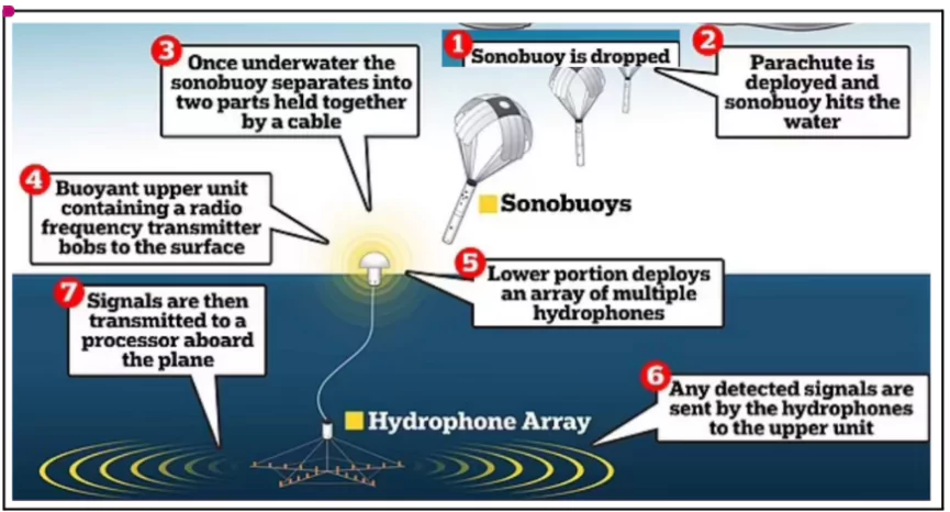
Underwater Domain Awareness (UDA) 

  • Definition: UDA is a combination of technologies, strategies, and policies aimed at monitoring and understanding undersea activities.
  • Significance: It addresses security threats, environmental challenges, and emerging issues like illegal fishing and marine pollution.
  • Strategic Importance: UDA enhances maritime security, ensures regional stability, and supports economic growth by protecting critical trade and energy routes.

India and UDA

  • Maritime Interests: India’s vast coastline, exclusive economic zone (EEZ), and strategic position in the Indian Ocean Region (IOR) underline the importance of robust UDA capabilities.
  • Technological Advances: Deployment of Unmanned Underwater Vehicles (UUVs) like ADAMYA and integration of sonobuoys with drones showcase India’s technological progress in underwater surveillance.
  • Strategic Initiatives: Programs like the Integrated Underwater Harbour Defence and Surveillance System (IUHDSS) strengthen India’s maritime security infrastructure.
  • Challenges: India faces hurdles such as dependency on foreign technology, resource constraints, and complex geopolitical dynamics, including Chinese naval activity in the IOR.
  • Opportunities: UDA aids in fostering maritime diplomacy, securing trade routes, and enabling environmental protection, thereby enhancing India’s role as a key maritime stakeholder.

India’s coastline has grown by 47.6%, from 7,516 km in 1970 to 11,098 km in 2023-24. The increase is due to the adoption of new methodologies for measuring coastal features.

Comparison: Old vs. New Measurement Methodology

Aspect Old Methodology (1970) New Methodology (2023-24)
Basis of Measurement Straight-line distances Included complex coastal formations
Coastal Features Measured Limited to general shoreline length Incorporated bays, estuaries, inlets, and other geomorphological features
Technology Used Basic tools and manual calculations Advanced geospatial technologies and mapping tools
Accuracy Relatively less precise More precise representation of dynamic coastline
Reported Coastline Length 7,516 km 11,098 km

Enroll now for UPSC Online Classes

Coastline Changes by States and UTs

  • States/UTs with Significant Growth

    • Gujarat: Increased from 1,214 km (1970) to 2,340 km (2023-24).
      • Accounts for the largest absolute growth in coastline length.Retains the position of the state with the longest coastline.
    • West Bengal: Percentage increase of 357%, from 157 km to 721 km, marking the highest growth in percentage terms.
    • Tamil Nadu: Revised length increased to 1,068 km from 906 km, overtaking Andhra Pradesh.
  • States/UTs with Minimal or Negative Changes

    • Kerala: Recorded the smallest increase, adding only 30 km (5%).
    • Puducherry: The coastline shrank by 4.9 km (-10.4%), due to erosion and recalculation.
  • Tamil Nadu vs. Andhra Pradesh: Tamil Nadu now ranks higher than Andhra Pradesh in coastline length after the new measurement.
  • Puducherry’s Contraction: Shrinkage attributed to erosion and refined calculations, contrasting the general trend of coastline growth elsewhere.

India's Coastline

Impact of Coastline Expansion

  • Economic Development
    • Ports and Infrastructure: Andhra Pradesh is developing ports like Ramayapatnam, Krishnapatnam, and Kakinada Gateway to boost logistics, industrialization, and employment.
    • Maritime Economy: Coastal states and UTs are leveraging expanded coastlines for enhanced maritime trade and tourism.

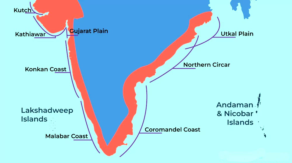
Coastlines of Emergence and Submergence

  • Coastlines of Emergence: Occur when land is raised (uplifted) or when the sea level is lowered.
    • Examples of features include bars, spits, lagoons, salt marshes, beaches, sea cliffs, and arches.
  • Examples in India:
    • Tamil Nadu Coast (Coromandel Coast)
    • Kerala Coast (Malabar Coast)
  • Coastlines of Submergence: Created when land is submerged due to subsidence or when the sea level rises.
  • Examples in India:
    • India’s West Coast: Displays both emergence and submergence.
      • Northern Portion: Submerged due to faulting.
      • Kerala Coast: An emerging section of the shoreline.

  • Biodiversity and Environmental Considerations
    • Expanded coastline data aids in better conservation of coastal biodiversity.
    • Improved mapping supports monitoring coastal erosion and accretion.
  • Policy and Planning: Accurate coastline data is crucial for maritime security, infrastructure planning, and disaster preparedness.

Check Out UPSC NCERT Textbooks From PW Store

Geographical Coverage of India’s Coastline

  • Regions: Bordered by the Bay of Bengal (east), Indian Ocean (south), and Arabian Sea (west).
  • States and UTs:
    • Coastal states: Gujarat, Maharashtra, Goa, Karnataka, Kerala, Tamil Nadu, Andhra Pradesh, Odisha, and Bengal.
    • UTs: Daman & Diu, Lakshadweep, Puducherry, and Andaman & Nicobar Islands.

Researchers have demonstrated that reducing nitric oxide (NO) levels in plants significantly improves nitrogen uptake and Nitrogen Use Efficiency (NUE) in rice and Arabidopsis.

Nitrogen Use Efficiency (NUE)

  • NUE describes the efficiency of plants in using nitrogen, whether applied as fertilizer or fixed from the atmosphere, for biomass production.
  • It is measured as the ratio between crop yield and the nitrogen absorbed from soil or atmosphere.

Key Findings of the Study

  • This study highlights a promising approach for sustainable agricultural practices by encouraging ways to reduce NO levels in plants.
  • Significance of Nitric Oxide (NO)
    • Nitric oxide (NO) plays a crucial role in regulating various physiological processes in plants.
    • Lowering NO levels activates high-affinity nitrate transporters (HATs), which are especially effective under limited nitrogen conditions.
  • High-Affinity Nitrate Transporters (HATs):High-affinity nitrate transporters are essential for nitrogen uptake, particularly in low nitrogen conditions.

Enroll now for UPSC Online Course

Methods Used to Improve NUEPharmacological Manipulation: Researchers used chemical compounds known as nitric oxide (NO) scavengers to reduce NO concentration in plants.

  • Overexpressing Phytoglobin: Phytoglobin, a natural nitric oxide scavenger, was overexpressed in plants.
  • This increased the expression of high-affinity nitrate transporters (HATs) like NRT2.1 and NRT2.4, enhancing nitrogen uptake under low NO conditions.
  • Genetic Manipulation: Genetic manipulation involves altering plant genes to regulate nitric oxide levels in cells.
  • Protein Nitrosylation: Protein nitrosylation, a biochemical modification by nitric oxide, plays a significant role in nitrogen regulation.
    • Targeting protein nitrosylation has shown potential in improving NUE.

Importance of Improving NUE

  • Enhancing NUE helps reduce the excessive use of nitrogen fertilizers.
  • It mitigates environmental pollution, including nitrate leaching and greenhouse gas emissions.
  • Improved NUE contributes to increasing crop yields sustainably.

Tidal Tail

Context: A new ultra-diffuse galaxy forming at the end of a tidal tail associated with the galaxy NGC 3785 has been identified recently.

  • Discovery: A team of researchers from the National Centre for Radio Astrophysics (NCRA) Pune and Indian Institute of Astrophysics (IIA) conducted a detailed photometric analysis of the Tidal Tail of the NGC 3785 Galaxy.
    • NGC 3785 Galaxy: The Galaxy is about 430 million light years from Earth situated in the Leo constellation.
  • Tidal Tail
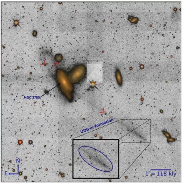
Published in: The study was published in the European journal, Astronomy & Astrophysics Letters
  • The Formation of an Ultra-Diffuse Galaxy: At the end of the tidal tail of NGC 3785, astronomers have observed the formation of a nascent ultra-diffuse galaxy (UDG). 
    • Ultra -Diffuse Galaxy: These are characterized by their low luminosity and surface brightness, often eluding detection in traditional surveys.
    • Formation of these galaxies are driven by the gravitational interaction between NGC 3785 and a neighboring galaxy.
  • Significance: 
    • Understanding Galaxy Evolution: It will open up new avenues for understanding how galaxies evolve and interact in the vast universe.
    • Finding new Cosmic Structures: This research highlights the processes involved in galaxy interactions and the creation of new structures in the cosmos.

About Tidal Tail

  • A tidal tail is a long, thin stream of stars and interstellar gas that forms when two galaxies interact closely pulling material away from each galaxy.
  • Formation: The gravitational interactions between galaxies can occur during close encounters or mergers, where the gas and stars are often stripped from the outer regions of the galaxies to form two tidal tails,
    • One  trailing and one preceding each galaxy.
  • Longest Tidal Tail: The tidal tail of Galaxy NGC 3785 extends for an astonishing 1.27 million light-years, making it the longest ever discovered.

Check Out UPSC Modules From PW Store

Henley Passport Index 2025

Context: Singapore has reclaimed its place at the top of the world’s most powerful passports which enjoy visa-free access to 195 out of 227 destinations worldwide, according to the Henley Passport Index.

India’s Ranking

  • 2025 Rank: 85th. 
    • Visa-free access to 57 nations.
  • Recent Trends: Recovery from 90th (2021) to 80th (2024) but dropped to 85th (2025).

Henley Passport Index 2024

  • Original, authoritative ranking of world passports based on destinations accessible without a prior visa.
  • Initiated in 2006 as the Henley & Partners Visa Restrictions Index (HVRI).
  • Utilizes data from the International Air Transport Association (IATA) and Henley & Partners’ research team.
  • Data and Coverage: Index includes 199 passports and 227 travel destinations.
    • Passport’s visa-free ‘score’ is determined by the number of countries it provides access to without a visa.
  • Index Authority: Considered the standard reference tool for global citizens and sovereign states in assessing passport rankings and global mobility.

Aiming for UPSC?

Download Our App

      
Quick Revise Now !
AVAILABLE FOR DOWNLOAD SOON
UDAAN PRELIMS WALLAH
Comprehensive coverage with a concise format
Integration of PYQ within the booklet
Designed as per recent trends of Prelims questions
हिंदी में भी उपलब्ध
Quick Revise Now !
UDAAN PRELIMS WALLAH
Comprehensive coverage with a concise format
Integration of PYQ within the booklet
Designed as per recent trends of Prelims questions
हिंदी में भी उपलब्ध

<div class="new-fform">


    </div>

    Subscribe our Newsletter
    Sign up now for our exclusive newsletter and be the first to know about our latest Initiatives, Quality Content, and much more.
    *Promise! We won't spam you.
    Yes! I want to Subscribe.