Dec 26 2024

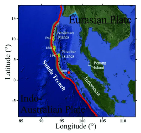
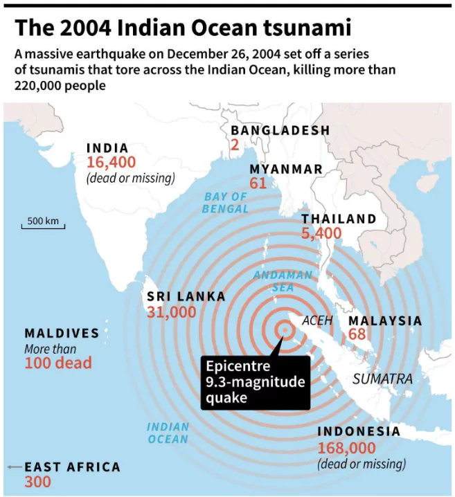
December 26, 2024, marks the 20th year since the 2004 Indian Ocean earthquake and tsunami. 

About Indian Ocean Tsunami of 2004

Indian Ocean Tsunami

  • The 2004 tsunami occurred on December 26, triggered by a magnitude 9.1 earthquake in the Sunda Trench.
  • The disaster affected 14 countries, including Indonesia, Sri Lanka, India, and Thailand.
  • Over 2,27,000 people lost their lives, making it one of the deadliest natural disasters in history.
  • Source of Indian Ocean Tsunami
    • It is the third largest since 1900, originating 30 km below the ocean floor in the Sunda trench.
    • It ruptured 1,300 km of the plate boundary, extending from Sumatra to the Coco Islands.
    • The Indo-Australian plate subducted beneath the Burma microplate, part of the Eurasian plate, triggering the tsunami.

Enroll now for UPSC Online Course

About Sunda Trench

Indian Ocean Tsunami

  • The Sunda Trench is the deepest ocean trench of the Indian Ocean. 
  • Location: Located in the eastern Indian Ocean, south and west of the islands of Java and Sumatra. 
    • It stretches from the Andaman Islands, past Java, around the southern coast of Sumatra, and to the Lesser Sunda Islands. 
  • Length: 3,200 kilometers (2,000 miles) long. 
  • Depth: Maximum depth is 7,290 meters (23,920 feet). 
  • Formation: Formed when the Australian-Capricorn plates subducted beneath the Eurasian plate. 
  • Seismic activity: The Sunda Trench is part of the Pacific Ring of Fire and is seismically active. 

About Tsunami

Indian Ocean Tsunami

  • Definition: A series of large ocean waves caused by underwater disturbances such as earthquakes, landslides, or volcanic eruptions.
  • Etymology: Derived from the Japanese words “tsu” (harbor) and “nami” (wave).
  • Causes of Tsunami
    • Submarine Earthquakes: Most common cause (e.g., 2004 Indian Ocean tsunami caused by a 9.1 magnitude earthquake).
    • Volcanic Eruptions: Sudden displacement of water due to eruptions (e.g., 1883 Krakatoa eruption).
    • Landslides: Coastal or submarine landslides can generate tsunamis. (e.g., 2017 Karrat Fjord landslide, Greenland)
    • Asteroid Impacts: Rare but catastrophic; can generate massive waves.
  • Characteristics:
    • Formation and Triggering: The primary mechanism involves the sudden displacement of a large volume of water.
    • Indian Ocean Tsunami
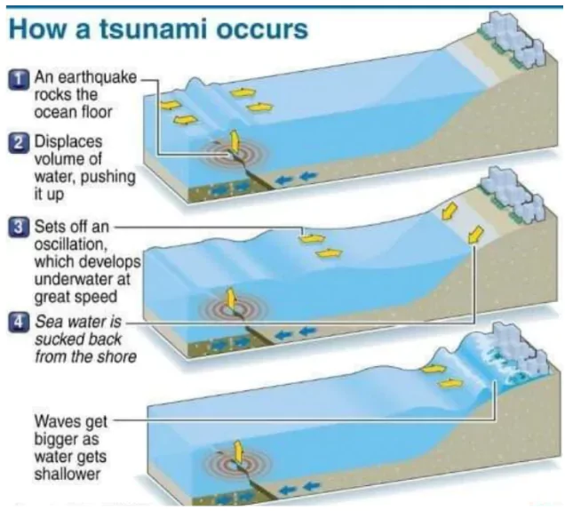
Speed and Propagation: In deep oceans, tsunamis can travel at speeds up to 800 km/h, comparable to the speed of a jet aircraft.
      • The speed depends on the depth of the water, decreasing as the tsunami approaches shallow coastal waters.
    • Wave Properties: 
      • Wavelength: Tsunamis have extremely long wavelengths, often exceeding 500 km.
      • Wave Period: The time between successive waves can range from 10 minutes to 2 hours.
      • Wave Amplitude (Height): In deep water, wave heights are typically small (30–60 cm), making them undetectable by ships.
    • Shoaling Effect: As tsunamis enter shallow waters, their speed decreases, and wave heights increase dramatically due to energy conservation.
      • This transformation can cause wave heights to reach 10–30 meters or more near the coastline.
    • Multiple Waves: Not a single wave but a series of waves known as a wave train.
      • The first wave is often not the largest, with subsequent waves potentially causing more destruction.
    • Energy Conservation: Lose minimal energy as they propagate across oceans due to their long wavelengths, making them capable of causing damage over vast distances.
  • Tsunami Hotspots: Tsunamis are frequently observed along the Pacific Ring of Fire, particularly along the coast of Alaska, Japan, the Philippines and other islands of Southeast Asia, Indonesia, Malaysia, Myanmar, Sri Lanka, and India.

Environmental and Economic Impact of Tsunamis

  • Environmental Impact
    • Destruction of Ecosystems: Loss of natural barriers like Mangroves, Coral Reefs, and Forests, increases vulnerability to future coastal hazards.
      • The 2004 Indian Ocean tsunami caused extensive damage to coral reefs and mangroves in Indonesia, with 90% of mangroves in some regions destroyed​.
    • Soil and Water Contamination: Pollution from hazardous materials mixed with debris further degraded the environment.
      • Saltwater Intrusion: The 2004 tsunami rendered 62,000 wells in Sri Lanka unusable due to saltwater contamination. Agricultural lands became infertile due to salination and debris​.
    • Marine Pollution: The tsunami dragged tons of waste, including plastics and hazardous materials, into the ocean. In Banda Aceh, Indonesia, tsunami debris significantly affected marine ecosystems​.
    • Loss of Biodiversity: The 2004 tsunami caused extensive habitat destruction, leading to a decline in populations of coastal and marine species.
    • Geographical Shifts: The 2004 tsunami shifted the North Pole by 2.5 cm and reduced the length of the day by 2.68 microseconds. 
      • The Andaman and Nicobar Islands were reported to have shifted by 1.25 meters​.
  • Economic Impact
    • Loss of Livelihoods: In Tamil Nadu, India, over 30,000 fishing boats were destroyed during the 2004 tsunami, crippling the fishing industry. 
      • Salination of agricultural lands in Indonesia and Sri Lanka led to reduced crop yields​​.
    • Infrastructure Damage: The tsunami caused massive destruction of infrastructure, including ports, roads, and buildings.
      • Overall economic losses from the 2004 Indian Ocean Earthquake and Tsunami disaster are estimated at $10 billion, with 75% of the loss attributed to the damage in Indonesia,Thailand, Sri Lanka, and India.
    • Tourism Sector Collapse: Tsunamis can directly damage tourism destinations, such as hotels, resorts, and other businesses. 
    • Public Health and Sanitation: Tsunami risk of water-borne diseases and respiratory diseases due to crowding in temporary shelters and inadequate water and sanitation,
      • Contaminated water sources and damaged sanitation facilities in Sri Lanka led to outbreaks of waterborne diseases, increasing healthcare expenditure.
      • Between 1998-2017, tsunamis caused more than 250 000 deaths globally, including more than 227 000 deaths due to the Indian Ocean tsunami in 2004.  
    • Cost of Waste Management: In Banda Aceh, Indonesia, the sheer volume of mixed waste required extensive resources for environmentally sound disposal​.

Check Out UPSC CSE Books From PW Store

Steps Taken For Tsunami Preparedness

Tsunami Early Warning Systems

  • Global Tsunami Early Warning Systems
    • Key Organizations and Initiatives
      • Pacific Tsunami Warning Center (PTWC):
        1. Established in 1949, located in Hawaii.
        2. Monitors seismic activity in the Pacific Ocean.
      • UNESCO-IOC Global Network:
        1. Created after the 2004 Indian Ocean tsunami to establish regional warning systems worldwide.
        2. Includes the Indian Ocean Tsunami Warning and Mitigation System (IOTWMS) and Caribbean Tsunami Warning System.
      • Indian Ocean Tsunami Warning and Mitigation System (IOTWMS):
        1. Established in 2005 as a response to the 2004 Indian Ocean tsunami under UNESCO coordination.
        2. Supported by regional centers in India, Indonesia, and Australia.
    • Technological Components:
      • Deep-Ocean Assessment and Reporting of Tsunamis (DART):
        1. Measures changes in water pressure on the ocean floor to detect tsunami waves.
        2. Currently, 75 DART buoys operate globally, providing real-time data.
      • Sea Level Monitoring Stations:
        1. Increased from 1,000 in 2004 to over 14,000 globally​.
    • Capabilities
      • Early warning systems now issue alerts within 5-7 minutes of an earthquake, compared to 15-20 minutes in 2004.
      • Real-time data integration enables accurate tsunami modeling and faster dissemination.

The Disaster Management Act 2005

  • The Disaster Management Act, 2005 lays down institutional, legal, financial and coordination mechanisms at the National, State, District and Local levels to manage Disasters in India.
  • It was passed in the wake of the 2004 tsunami.
  • Nodal Ministry: Ministry of Home Affairs overseeing the nation’s comprehensive disaster management.
  • Objectives: 
    • To establish an efficient and decentralised disaster management system for the country at all levels (National, State, Districts) with corresponding Roles and Responsibilities. 
    • The Act deals with Disaster holistically from The Mitigation aspect (capacity building) to Risk Assessment and the Crisis Management aspect covering  relief, rehabilitation, and response measures.

  • Indian Tsunami Early Warning System (ITEWS)
    • Established in 2007 at the Indian National Centre for Ocean Information Services (INCOIS), Hyderabad.
      • Indian Ocean Tsunami
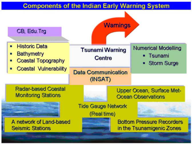
Functions as a Tsunami Service Provider (TSP) for 28 Indian Ocean Rim countries.
    • Part of the Indian Ocean Tsunami Warning & Mitigation System (IOTWMS),
    • Key Components
      • Seismic Monitoring Network:
        1. Tracks seismic activity in real time, integrating data from national and global networks.
      • Bottom Pressure Recorders (BPRs):
        1. Detects minute changes in water pressure; 12 BPRs installed in the Indian Ocean.
      • Tide Gauges and Radar Systems:
        1. Monitors coastal water levels to confirm tsunami presence.
      • Decision Support System (DSS):
        1. Automatically generates and disseminates alerts via SMS, email, and mobile applications (e.g., SAMUDRA app).
    • Preparedness Measures
      • Regular mock drills and capacity-building workshops.
      • Implementation of the UNESCO-IOC Tsunami Ready Program:
        1. Villages like Venkatraipur and Noliasahi in Odisha were recognized as “Tsunami Ready” in 2020​.
    • Achievements
      • India now ranks as one of the five countries with advanced tsunami warning systems, alongside the U.S., Japan, Chile, and Australia.
      • Can issue tsunami advisories within 10 minutes of occurrence of an earthquake​​.
    • Collaboration and Technology
      • INCOIS collaborates with ISRO and NDMA to enhance communication systems.
      • NAVIC Satellite Integration: Ensures real-time alerts for coastal communities.

Check Out UPSC NCERT Textbooks From PW Store

About IOC-UNESCO and Tsunami Ready Recognition Programme (TRRP)

  • The Intergovernmental Oceanographic Commission of UNESCO (IOC/UNESCO) promotes international cooperation in marine sciences to improve management of the ocean, coasts and marine resources. 
  • The IOC is in charge of coordinating the United Nations Decade of Ocean Science for Sustainable Development 2021-2030, the “Ocean Decade”.
  • UNESCO-IOC Tsunami Ready Recognition Programme (TRRP): The TRRP enhances community preparedness for tsunamis through education, training, and response planning.
    • Communities are evaluated by IOC-UNESCO on 12 specific indicators.

Challenges with Early Warning Systems

  • Detection Limitations in Near-Field Tsunamis: Tsunamis generated near coastlines allow minimal time for detection and warning dissemination.
    • The Hunga Tonga-Hunga Ha’apai volcanic eruption 2022 produced waves that reached nearby islands within minutes, overwhelming the warning systems. 
  • Lack of Coverage in Some Regions: Many coastal nations do not have comprehensive tsunami warning systems. 
    • In East Africa, countries like Somalia remain vulnerable due to limited monitoring capabilities.
  • Technological and Maintenance Challenges: Systems like DART buoys and tide gauges require regular maintenance, which can be costly and logistically challenging.
    • Several DART buoys in the Indian Ocean were reported non-functional in 2018, potentially reducing the efficacy of warnings.
  • Delay in Communication and Decision-Making: Early warning systems require efficient communication networks to disseminate alerts to authorities and the public promptly.
    • During the Indian Ocean-wide tsunami exercise (IOWave23), gaps were identified in local-level communication systems, delaying evacuation orders despite mock warnings reaching regional centers​
  • Public Awareness and Response Gaps: Even with timely warnings, unprepared communities may fail to respond appropriately.
    • In some parts of Sri Lanka and Thailand during the 2004 tsunami, people did not recognize natural warning signs, such as sea recession, leading to higher casualties.
  • Integration of Data from Multiple Sources: Combining real-time data from seismic stations, BPRs, and tide gauges is complex and may cause delays.
    • Inconsistencies in data interpretation during smaller tsunamis can lead to false alarms, eroding public trust in the warning system.
    • After Alaska Earthquake 2021, a tsunami warning issued after an 8.2 magnitude earthquake caused panic but was later canceled when no significant waves were observed.

Way Forward for Managing Tsunami Impacts and Enhancing Early Warning Systems

  • Strengthen Monitoring Infrastructure: Expand networks of seismic stations, tide gauges, and DART buoys, particularly in underserved regions like East Africa and the Arabian Sea.
    • Incorporate advanced technologies like AI and machine learning for real-time tsunami modeling and enhanced prediction accuracy.
  • Enhance Community Resilience: Conduct regular mock drills, public awareness campaigns, and capacity-building workshops in vulnerable coastal regions.
    • Scale up successful programs like UNESCO-IOC’s Tsunami Ready initiative in countries across the Indian Ocean.
  • Integrate Nature-Based Solutions: Restore and protect natural barriers like mangroves, coral reefs, and sand dunes to reduce the energy of tsunami waves.
    • The presence of mangroves significantly mitigated impacts during the 2004 tsunami in regions like Odisha, India.
  • Promote Regional and Global Collaboration: Enhance data-sharing and joint preparedness exercises among Indian Ocean Rim countries.
    • Strengthen coordination through regional centers like the Indian Tsunami Early Warning Centre (ITEWC).
  • Incorporate Risk Reduction in Coastal Development: Integrate tsunami risk assessments into urban planning and coastal development projects.
    • Build resilient infrastructure, including elevated shelters and tsunami-resistant structures, particularly in high-risk zones.
  • Mitigate Financial Risks: To mitigate the risks, develop the mechanism like catastrophe bonds.
    • A catastrophe bond is a financial instrument that transfers financial risk connected with exposure to natural disasters to capital market investors.

Enroll now for UPSC Online Classes

Conclusion

An integrated approach combining technology, natural barriers, public engagement, and international cooperation is essential to mitigate tsunami impacts and enhance early warning systems. Strengthening preparedness and response capacities will ensure long-term resilience for coastal communities.

India, with its burgeoning population of 145 crore, faces an annual increase in food demand of 2-3%, requiring a 50% rise in food production by 2050.

  • Despite its self-reliance in food and nutrition, the country’s current agricultural practices are unsustainable.

What is Regenerative Farming?

  • Regenerative farming is an agroecological approach designed to restore soil health, enhance biodiversity, and improve ecosystem services.
  • The term “regenerative agriculture” was coined in the 1980s by the Rodale Institute, a nonprofit research institution.

Enroll now for UPSC Online Course

Regenerative Agriculture

Unique aspects of Regenerative Agriculture

  • Beyond Sustainability: Unlike sustainable farming, which maintains the status quo, regenerative agriculture focuses on improving soil health, biodiversity, and ecosystem resilience.
  • Soil-Centric Approach: Regenerative agriculture prioritizes soil regeneration through microbial-plant symbiosis, enhancing nutrient cycling and carbon sequestration.
  • Holistic Practices: Combines principles of agroecology and conservation agriculture while remaining adaptable to local conditions.
  • Dynamic and Inclusive: Allows flexibility in methods like zero tillage, crop diversification, and livestock integration, tailored to specific environments.
  • Mutual Benefits: Supports healthier soils, nutrient-rich crops, and reduced greenhouse gas emissions, benefiting both the environment and food systems.

Common Practices in Regenerative Agriculture

  • Soil and Crop Management: Practices like no-till farming, cover cropping, crop rotation, and organic inputs improve soil fertility, reduce erosion, and enhance biodiversity.
  • Integrated Systems: Methods such as silvopasture, agroforestry, permaculture, and biodynamic farming promote sustainable landscapes and ecosystem health.
  • India’s Zero Budget Natural Farming (ZBNF) is a key example, emphasizing natural inputs and holistic soil regeneration to achieve sustainable agriculture.

Benefits

  • Reduced Emissions: It helps mitigate emissions such as through carbon sequestration and improved crop resilience for climate shocks.
    • For Example: Regenerative farming on 40% of the world’s cropland would save around 600 million tons of emissions. This is around 2% of the total, equivalent to the footprint of Germany.
  • Soil health: Regenerative agriculture improves soil health by: 
    • Recycling farm waste and adding composted material 
    • Using cover crops year-round to prevent bare soil and reduce erosion 
    • Incorporating livestock into crop production 
    • Preserving the live roots of perennial crops 
  • Biodiversity: Regenerative agriculture increases biodiversity by: Using crop rotation, agroforestry, and silvopasture techniques 
  • Water conservation: Regenerative agriculture conserves water by promoting judicious use of groundwater 
  • Economic well-being: Regenerative agriculture improves the economic well-being of farmers by: 
    • Reducing input costs 
    • Increasing farm productivity and profits 

Need of Regenerative Agriculture

  • Soil Degradation: Excessive use of synthetic fertilisers and unsustainable agricultural practices have significantly reduced soil fertility.
    • The soil organic carbon content has dropped alarmingly from 2.4% in 1947 to 0.4% today, far below the essential threshold of 1.5% required for maintaining arable soil properties.
    • This degradation has cost India approximately Rs 47.7 lakh crore ($564 billion) over the last 70 years, or Rs 68,243 crore ($8.06 billion) annually in lost carbon value.
  • Water Scarcity: Over-reliance on groundwater for irrigation has led to severe depletion and quality deterioration.
  • Regenerative Agriculture
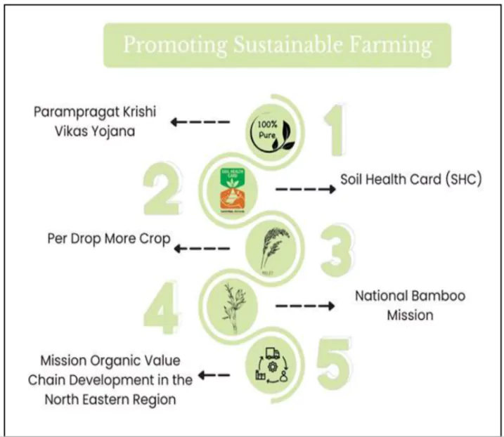
Climate Change: The increasing frequency of droughts, floods, and extreme temperature events adversely affects agricultural productivity.
    • Climate impacts, coupled with declining soil health and inefficient practices, compound the risks to food security.
  • Economic Pressures: Farmers face high input costs and fluctuating market prices, straining their financial stability.
    • The current Rs 2 lakh crore ($25 billion) annual subsidy to the fertiliser industry supports the inefficient use of synthetic inputs, further harming soil health and increasing greenhouse gas emissions by approximately 25 million tonnes (CO2e) annually, at an additional cost of Rs 14,813 crore ($1.75 billion).
  • Knowledge Gaps: Many rural farmers lack awareness of sustainable farming techniques.
    • Limited access to training and resources hinders the adoption of regenerative and climate-resilient practices.

Check Out UPSC CSE Books From PW Store

Way Forward

  • Policy Support: Formulate incentives for adopting sustainable practices and reducing fertiliser subsidies.
  • Research and Development: Conduct intensive field studies across agro-climatic zones to generate evidence on the benefits of regenerative agriculture.
  • Awareness Campaigns: Educate farmers and stakeholders about the economic, environmental, and health advantages of these practices.
  • Collaborative Models: Engage local communities, non-governmental organisations, and private sectors in scaling sustainable techniques.

Conclusion

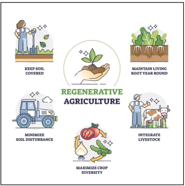
Adopting regenerative farming is crucial for India to achieve its goals of food, nutritional, and ecological security while progressing toward its vision of net-zero emissions by 2070. By reimagining agriculture through agroecological principles, India can safeguard its soil and ensure a sustainable future for generations to come.

Recently, the Padmaja Naidu Himalayan Zoological Park in Darjeeling received two red pandas from the Netherlands. 

About Red Pandas( Ailurus fulgens)

Red Pandas

  • Species Variety:  
    • Giant Pandas and Red Pandas.
  • State Animal: Red Panda is the state animal of Sikkim.
  • Subspecies in India:
    • Himalayan Red Panda (Ailurus fulgens).
    • Chinese Red Panda (Ailurus styani).
      • The Siang River in Arunachal Pradesh geographically separates these two subspecies.
  • Diet: Primarily herbivorous, bamboo makes up the majority of their diet. They also supplement their diet with fruits, insects, and eggs.
  • Shy and  solitary animals :Red pandas are primarily solitary animals, coming together only for mating and raising young.
  • Red PandasRole: Serve as an indicator species for ecological changes.
    • They help to disperse seeds as they move through the forest, and their diet of bamboo can help to control the growth of this fast-growing plant. 
    • They are also an important prey species for larger predators such as snow leopards.
  • Feature: 
    • Color: Their most striking feature is their reddish-brown fur, which helps them blend in with their forest environment. 
      • Long, bushy tails help in maintaining balance and provide warmth in winter.
    • Arboreal: They are excellent climbers, spending much of their time in trees. 

Enroll now for UPSC Online Course

  • Red Pandas
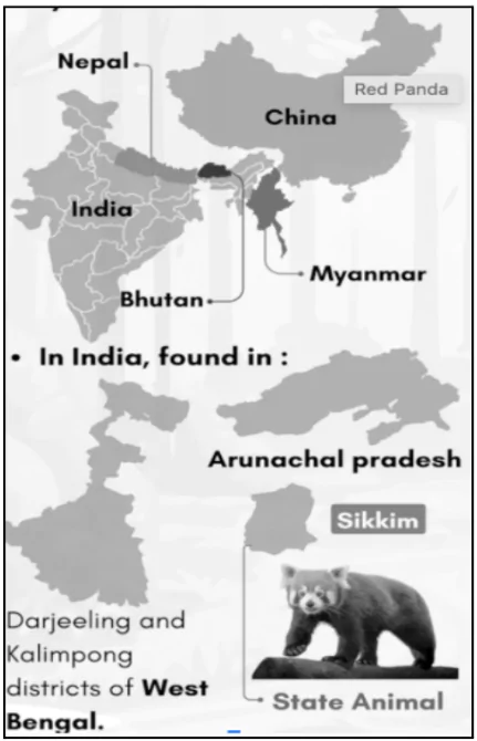
Distribution: Bhutan, China, India, Myanmar, and Nepal.
    • Approximately 50% of their habitat lies in the Eastern Himalayas.
  • Threats: Habitat loss due to the decline of nesting trees and bamboo in the Eastern Himalayas.
  • Protection Status
    • IUCN Red List: Endangered.
    • CITES: Appendix I.
    • Wildlife Protection Act, 1972: Schedule I.

About Padmaja Naidu Himalayan Zoological Park (PNZP)

  • Location: Darjeeling, West Bengal, India.
  • Specialization: Breeding animals adapted to alpine conditions, with successful programs for species such as snow leopards, Himalayan wolves, and red pandas.
  • PNZP plays a pivotal role in red panda conservation and breeding efforts in India.
    • It houses a Biobanking and Genetic Resource Facility for preserving gametes, tissues, and DNA of endangered species.
    • It initiated a program to release 20 red pandas into the wild within five years.
    • The releases are set to occur in Singalila National Park , the highest national park in West Bengal located on Singalila Ridge in Darjeeling.

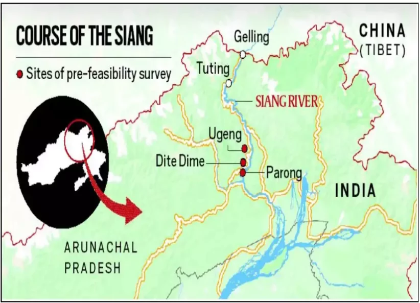
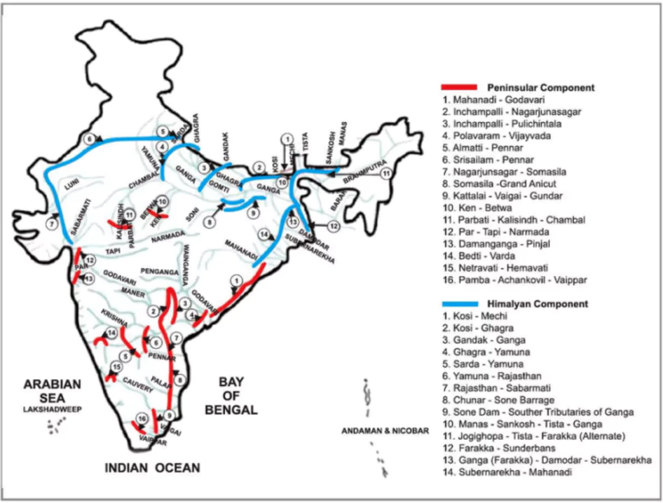
The Prime Minister laid the foundation stone for the ₹ 45,000-crore Ken-Betwa River Linking Project in Khajuraho, Madhya Pradesh.
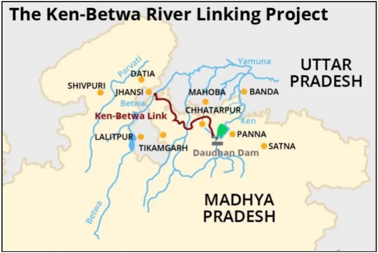
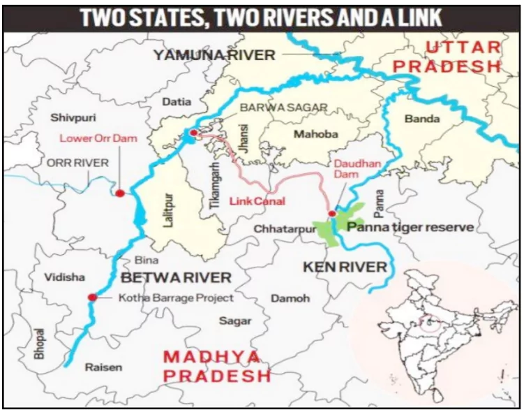
About Ken-Betwa Project

Ken-Betwa River Linking Project

  • The Ken-Betwa Project is a river interlinking initiative designed to transfer surplus water from the Ken River in Madhya Pradesh to the Betwa River in Uttar Pradesh.
  • A Special Purpose Vehicle (SPV), the Ken-Betwa Link Project Authority (KBLPA), will oversee the implementation of the project.
  • Successful implementation depends on consensus among the concerned states.

Benefits

  • Irrigation: The project aims to provide irrigation to Bundelkhand, one of India’s most drought-affected regions.
    • It is expected to address drinking and irrigation water needs of at least 10 districts of Madhya Pradesh and various districts of Uttar Pradesh.
  • Hydropower: The project is also aimed at generating more than 100 MW of hydropower and 27 MW of solar energy. 

Enroll now for UPSC Online Course

Concerns About Ken-Betwa Project

  • Environmental Impact:  A study by IIT-Bombay scientists highlighted that large-scale water transfers through river linking projects could lead to up to a 12% mean rainfall deficit in September due to altered land-atmosphere interactions.
  • Panna National Park Submergence: The project will submerge approximately 98 sq. km of Panna National Park, where tigers had gone extinct in 2009. It also requires felling 2-3 million trees.
  • Core Tiger Reserve: Approval for the Daudhan dam’s construction within the core area of Panna Tiger Reserve sets a controversial precedent for heavy infrastructure in national parks and tiger reserves.
  • Wildlife ConcernsGharial and Vulture Habitat: Dam threatens the Gharial population in the Ken Gharial Sanctuary and vulture nesting sites.
  • Socioeconomic Issues: Displacement of Families
    • 5,228 families in Chhatarpur district.
    • 1,400 families in Panna district face displacement due to submergence and land acquisition.
    • Protests highlight concerns over inadequate compensation and low benefits for affected locals in Panna district.
  • Economic Viability: The Supreme Court’s Central Empowered Committee (CEC) questioned the economic feasibility of the project, suggesting that other irrigation methods in the upper Ken basin be explored first.
  • Unprecedented Construction: The Union Environment Ministry approved infrastructure within the core of a tiger reserve, despite a lack of precedent for such projects in protected areas.

About Ken and Betwa Rivers

Ken-Betwa River Linking Project

  • Origin: Both rivers originate in Madhya Pradesh.
    • The Ken River starts from the north-west slopes of the Kaimur Range in Jabalpur, Madhya Pradesh, and meets the Yamuna River in Uttar Pradesh’s Banda district.
    • The Betwa River originates in the Vindhya Range near Hoshangabad, Madhya Pradesh, flows through Bundelkhand, and joins the Yamuna River at Hamirpur, Uttar Pradesh.
  • Tributaries: Both rivers are tributaries of the Yamuna River.
  • Dams on Betwa River: Rajghat, Paricha, and Matatila dams are located on the Betwa River.
  • Ken River passes through the Panna Tiger Reserve.

River Linking Projects

River linking projects involve the construction of canals and dams to transfer water from water-surplus river basins to water-deficient basins. This is often done to address water scarcity, improve irrigation, and generate hydropower.

Examples:

  • The Volga-Don Canal in Russia: Connecting the Caspian and Black Seas, this canal facilitates navigation and water transfer between the two major river basins.

Pros and Cons of River Linking Projects

Pros Cons
Water Security: Improves water availability in water-scarce regions. Environmental Impact: Can disrupt ecosystems, alter river flows, and impact biodiversity.
Irrigation: Increases agricultural productivity in water-deficient areas. Social Displacement: Can lead to displacement of communities and loss of livelihoods.
Hydropower Generation: Potential to generate significant hydropower. Geological Instability: Can trigger earthquakes and other geological hazards.
Navigation: Can improve navigation and transportation. High Cost: Construction and maintenance costs can be substantial.

Check Out UPSC Modules From PW Store

National Perspective Plan (NPP)

Ken-Betwa River Linking Project

  • The Government of India formulated the National Perspective Plan (NPP) for interlinking rivers in 1980.
  • The National Water Development Agency (NWDA) is responsible for executing the interlinking of rivers under the NPP.
  • The NPP consists of two components:
    • Himalayan Rivers Development Component.
    • Peninsular Rivers Development Component.
  • A total of 30 link projects have been identified under the NPP.
  • The Ken-Betwa Link Project (KBLP) is the first interlinking of rivers project under the NPP and is currently under implementation.

About National Water Development Agency (NWDA)

  • The NWDA is a registered society under the Department of Water Resources, River Development & Ganga Rejuvenation (DoWR, RD&GR), which functions under the Ministry of Jal Shakti (MoJS).
  • It was established in 1982 to conduct detailed studies, surveys, and investigations related to the National Perspective Plan (NPP) for Water Resources Development.
  • One of its key functions is to undertake, construct, repair, renovate, rehabilitate, and implement projects under the Pradhan Mantri Krishi Sinchayee Yojana (PMKSY).

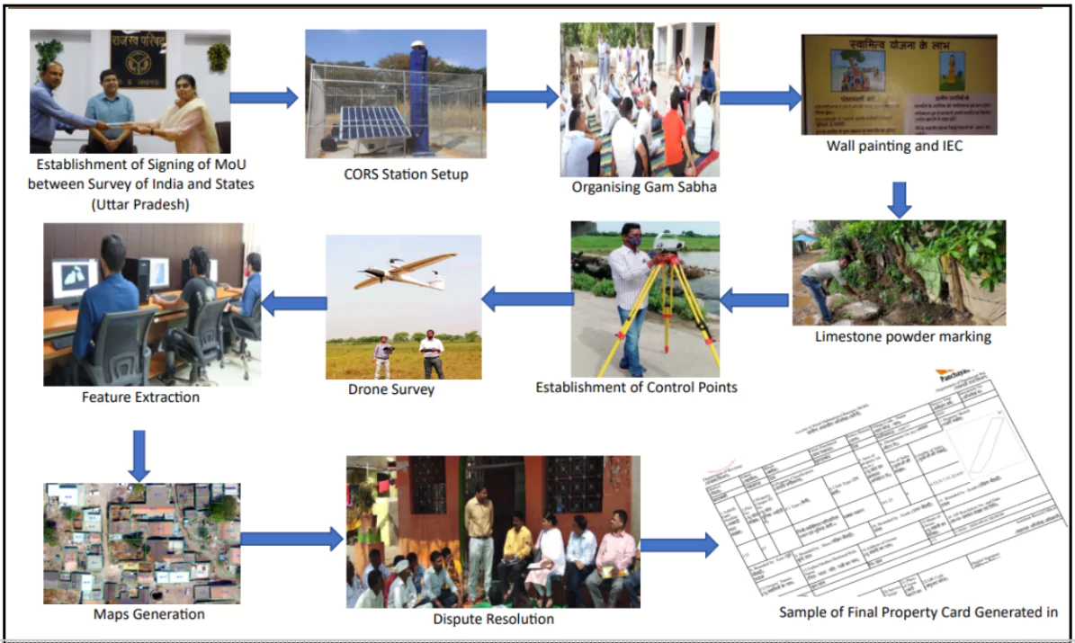
The Prime Minister will virtually distribute 58 lakh property cards, providing “record of rights” to property owners under SVAMITVA Scheme.

Implementation Status of  Svamitva Scheme

  • Drone Mapping: 92% of drone mapping has been completed, covering approximately 3.17 lakh villages out of the targeted 3.44 lakh villages.
    • The SVAMITVA scheme’s targets are expected to be fully achieved by 2026.
  • Participation by States and UTs: A total of 31 states and Union Territories have joined the initiative.
    • Sikkim, Telangana, and Tamil Nadu participated only during the pilot phase of the scheme.
  • Property Card beneficiaries include owners from over 50,000 villages across 12 States.

Enroll now for UPSC Online Course

About SVAMITVA Scheme

  • SVAMITVA Scheme (Survey of Villages and Mapping with Improvised Technology in Village Areas) is a Central Sector Scheme launched on National Panchayati Raj Day, 24th April 2020.
  • Aims:  To provide the ‘Record of Rights’ to village household owners possessing houses in inhabited areas (Abadi) in villages with issuance of legal ownership rights (Property cards/Title deeds)
  • Under the scheme, the land parcels in rural inhabited areas of all the villages of the country are surveyed.

CORS Network

  • CORS (Continuously Operating Reference Station) network provides a regional positioning service for highly accurate geospatial applications.
  • Infrastructure Functionality: Corrections to maps are instantly transmitted from the control center to the rover receiver.
    • Ensures real-time accurate positioning of the rover.
  • Role in Achieving High Accuracy: Enables centimetre-level accuracy for various applications.
  • Applications:
    • Cadastral Mapping: Ensures precision in property boundary demarcation.
    • Land Information Management: Supports efficient land administration.
    • Large-Scale Mapping: Useful for infrastructure projects and urban planning.

  • Implementing Agency: It is being implemented with the collaborative efforts of the Ministry of Panchayati Raj, Survey of India (SoI), State Revenue Department, State Panchayati Raj Department and National Informatics Centre
    • States need to sign Memorandum of Understanding (MoU) with SoI for implementation of the scheme. 
    • SoI is a technology partner for implementation
  • It also included  the establishment of the CORS network across states. 

About Property Cards

  • Property cards under the SVAMITVA scheme are legal documents that provide clear ownership records for rural properties. These cards are known by various names in different states, including:
    • Haryana: Title deed
    • Karnataka: Rural Property Ownership Records (RPOR)
    • Madhya Pradesh: Adhikar Abhilekh
    • Maharashtra: Sannad
    • Uttarakhand: Svamitva Abhilekh
    • Uttar Pradesh: Gharauni

Property Cards

Utility of Property Cards

  • Facilitating Financial Stability: Recognised by banks for loans, enabling property owners to use their land as a financial asset.
    • Provides access to financial benefits and ensures greater economic security for rural citizens.
  • Strengthening Women’s Ownership: Enhances property ownership for women, promoting gender equality in asset ownership.
  • Reducing Disputes and Tax Clarity: Minimises property-related disputes and legal cases by providing clear ownership records.
    • Facilitates the determination and collection of property tax.

Check Out UPSC CSE Books From PW Store

Overall Benefits of SVAMITVA Scheme

  • Improved Rural Planning: Aids in creating accurate land records for effective rural planning.It also identifies open spaces for better community development initiatives.
  • Enabling Quality Development Plans: Supports Gram Panchayats in preparing Gram Panchayat Development Plans (GPDP) using GIS-based maps.
    • Ensures participatory planning aligned with economic development and social justice goals, in convergence with the 29 subjects listed in the Eleventh Schedule of the Constitution.
  • Multi-Departmental Utility: Survey infrastructure and GIS maps can be leveraged by multiple departments for various applications.

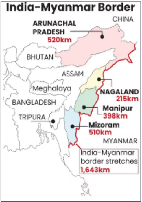
Months after suspending the Free Movement Regime (FMR) along the Myanmar border, the Union Home Ministry (MHA) has introduced a new protocol to regulate the movement of people living within 10 kilometers on either side of the largely unfenced international border.

Key Facts About Indo-Myanmar Border (IMB)

  • Length and Coverage: Total length of 1,643 kilometers.
    • It passes through Mizoram, Manipur, Nagaland, and Arunachal Pradesh.
  • Geographical Extent: Runs from the tripoint with China in the north to the tripoint with Bangladesh in the south.
  • Security: Guarded by the Assam Rifles.

FMR

Enroll now for UPSC Online Classes

About Free Movement Regime (FMR)

  • FMR permits hill tribes from both India and Myanmar to travel freely within a specified range along the Indo-Myanmar Border (IMB).
  • Border Crossing: Allowed with a border pass valid for one year, issued by a competent authority.
  • Duration of Stay: Visitors can stay for up to two weeks per visit.
  • Implementation: Initiated in 2018 as part of the Central Government’s Act East policy.

New Guidelines for Cross-Border Movement

  • Border Pass: Issued by Assam Rifles for a stay of up to seven days in the neighboring country.
    • Includes a photograph, QR code, and biometrics; must be returned upon completion of the visit.
  • Entry Process: Individuals must report at designated points, complete documentation, and undergo security and health checks.
  • Verification: Police will verify details on the border pass, and violations will lead to legal action.
  • Implementation Phases: Initial activation of eight pilot entry points, followed by 14 more after biometric systems are installed, with the remainder dependent on infrastructure readiness.

Reasons for Tightening Guidelines

  • Internal Security: Aimed at maintaining the demographic balance and preventing unregulated cross-border movement.
  • Ethnic Violence in Manipur: Movement across the border has been linked to violence in Manipur, which has resulted in over 250 fatalities since May 2023.
  • Political and Social Pressure: Influences from political and civil society groups prompted stricter measures rather than complete removal of the FMR.

Check Out UPSC NCERT Textbooks From PW Store

Issues with Previous FMR Implementation

  • Lack of Standardized Documentation: Absence of uniform border passes or recognition by both countries.
  • Implementation Gaps: Border passes were managed by state officials instead of a unified protocol.
  • Proposed Solutions: Plans include constructing a fence along the Indo-Myanmar border to enhance security and streamline movement.

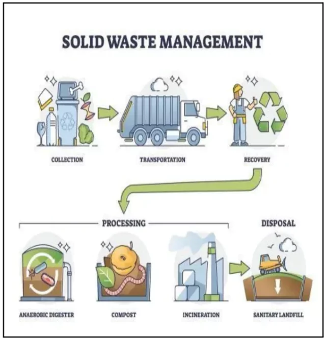
India’s Environment Ministry has drafted new rules for solid waste management rules 2024. 

  • Effective Date: The rules will come into force on October 1, 2025.

About Solid Waste Management

Solid Waste Management

  • Solid waste management refers to the process of collecting, transporting, treating, and disposing of solid waste.
  • Purpose: Ensures proper handling of waste to prevent environmental and health hazards.

What is Solid Waste? 

  • Solid Waste: Non-liquid, non-soluble materials from various sources, sometimes containing hazardous substances.
  • Types of Solid Waste:
    • Domestic waste: food craps
    • Commercial and institutional waste: discarded documents and packaging materials. 
    • Market and catering waste: spoiled fruits and vegetables
    • Bio-medical waste: used syringes and gloves
    • E-waste; old electronic devices. 
  • Current Scenario of Solid Waste in India
    • Production: India generates 277.1 million tonnes of solid waste annually.

Enroll now for UPSC Online Course

Key Highlights of the new Draft

  • Mandatory Waste Segregation
    • Sanitation workers can refuse to collect unsegregated waste.
    • Fines/Penalties may be imposed on residential complexes and bulk waste generators if waste is not segregated at source.
      • This is based on the principle of “pollution pays principal” which means those who cause pollution should be responsible for cleaning it up or paying for the damage. 
    • Waste must be separated into biodegradable and non-biodegradable categories (e.g., plastic, metal, glass).
  • Duties of Gated Communities and Institutions
    • Residential complexes, hotels, restaurants, and institutions with areas over 5,000 sqm must:
      • Segregate waste at source.
      • Ensure collection of waste in separate streams.
      • Hand over recyclable material to authorized waste pickers or recyclers.
    • Biodegradable waste should ideally be processed through composting or bio-methanation within the premises.
    • Residual waste must be given to authorized waste collectors as directed by local authorities.
  • Focus on Circular Economy
    • Unlike the previous rules, the new draft emphasizes market-based mechanisms for managing waste.
    • Provisions for ‘waste to energy’ processes and using solid waste in product manufacturing aim to promote circular economy practices.
  • Penalty for Non-Compliance
    • Environmental compensation (penalty) will be imposed based on the polluter pays principle for non-compliance.
  • Managing Agricultural Waste
    • Gram panchayats are responsible for ensuring no open burning of agricultural and horticultural waste.
      • In case, any person violates this rule, Heavy penalties will be levied against that person. 
Additional Reading: Waste Management in India, Current Policies, Regulations, and Challenges

Recently the Agreement between China and USA on Co-operation in Science and Technology has been extended for an additional five years, effective from August 27, 2024

About The U.S.-PRC Science and Technology Agreement (STA)

  • The STA provides consistent standards for U.S.-PRC bilateral government-to-government scientific cooperation. 
  • Signed On: The Agreement was first signed on January 31, 1979, by Chinese leader Deng Xiaoping and U.S. president Jimmy Carter to cooperate on agricultural research and technology.

About the Bilateral S&T Agreements

  • A bilateral science and technology (S&T) agreement is a pact between two countries to promote scientific and technological cooperation amongst them

International S&T Cooperation Agreements of India:

  • Implementing Agency: The International Cooperation Division of Department of Science and Technology is mandated with the responsibility of negotiating, concluding and implementing Science, Technology and Innovation (STI) Agreements between India and other countries
  • International Cooperation in STI is realized through,
    • Bilateral Cooperation: India has such bilateral agreements with 83 countries.
      • In recent years, the cooperation has strengthened significantly with Australia, Canada, EU, France, Germany, Israel, Japan, Russia, UK and USA
      • Example: The agreement between the United States and India, signed in 2005, which established intellectual property right protocols and other provisions for collaborative research
    • Multilateral & Regional Cooperation: These engagements are done through cooperation frameworks at inter-governmental level 
      • India’s S&T Cooperation with EU, ASEAN, BRICS, IBSA, SAARC, BIMSTEC, ASEM, EAS
    • Thematic Cooperation: IC Division is partnering in the following International programs,
      • International Solar Alliance; Mission Innovation; International AIDS Vaccine Initiative; The Laser Interferometer Gravitational-Wave Observatory (LIGO)

Check Out UPSC Modules From PW Store

    • Since then the Agreement has been renewed every five years 
  • Areas: The Agreement overtime has been extended to 40 sub-agreements in different areas, from agriculture to nuclear fusion.
  • Governed by: The US-PRC Joint Commission on Scientific and Technological Cooperation
    • The U.S. and China each appoint co-chairs and an agency from each country is nominated as the ‘executive agent’. 
  • Renewed with Amendments:
    • Safety and Accountability Provisions: It has measures to enhance provisions for researcher safety and data reciprocity to assuage US concerns over the export of certain technologies to China
    • Narrowing Scope: The collaboration will be confined to the intergovernmental level, to basic research, and to previously identified themes of mutual benefit (including, for example, earthquake studies and basic health) as of now. 
    • No Cooperation: Henceforth, No cooperation in critical and emerging technologies between the countries.
    • Area Focus:  The accord focuses on essential weather, oceanography, and geology research and will support U.S. agencies working on issues from tsunami warnings and influenza data to air quality and pest management.
  • Importance: 
    • For China: The agreement provides China access to American basic research which will help the country to plug a crucial gap within its science and technology industrial base and allow Beijing to maintain its technological competition with Washington. 
    • For the USA: The amended agreement will address Washington’s concerns over Beijing’s efforts to modernize its military through economic and scientific espionage by limiting joint research on critical and emerging technologies. 

‘Viksit Panchayat Karmayogi’

Context: The Centre launched the ‘Viksit Panchayat Karmayogi’ initiative on Good Governance Day to mark the 100th birth anniversary of former Prime Minister Atal Bihari Vajpayee.

About Viksit Panchayat Karmayogi’

  • This initiative is a part of the broader ‘Prashasan Gaon Ki Aur’ campaign.
  • Purpose: Strengthen grassroots governance by enhancing the capacity of Panchayati Raj Institutions (PRIs and promote equitable rural development.
  • Focus: Equip elected representatives and officials with tools for effective governance and participatory planning.
  • Implementation: Piloted in Odisha, Assam, Gujarat, and Andhra Pradesh.
  • Features:
    • Utilizes e-learning platforms, AI-powered chatbots, and mobile apps.
    • Aims to bridge knowledge gaps and improve service delivery.

Enroll now for UPSC Online Course

Greenland and the Panama Canal

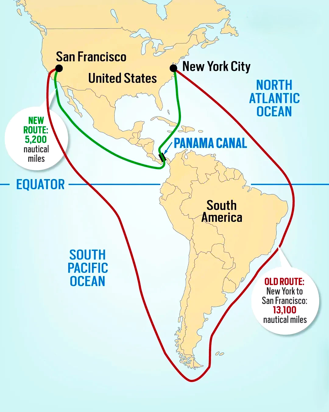
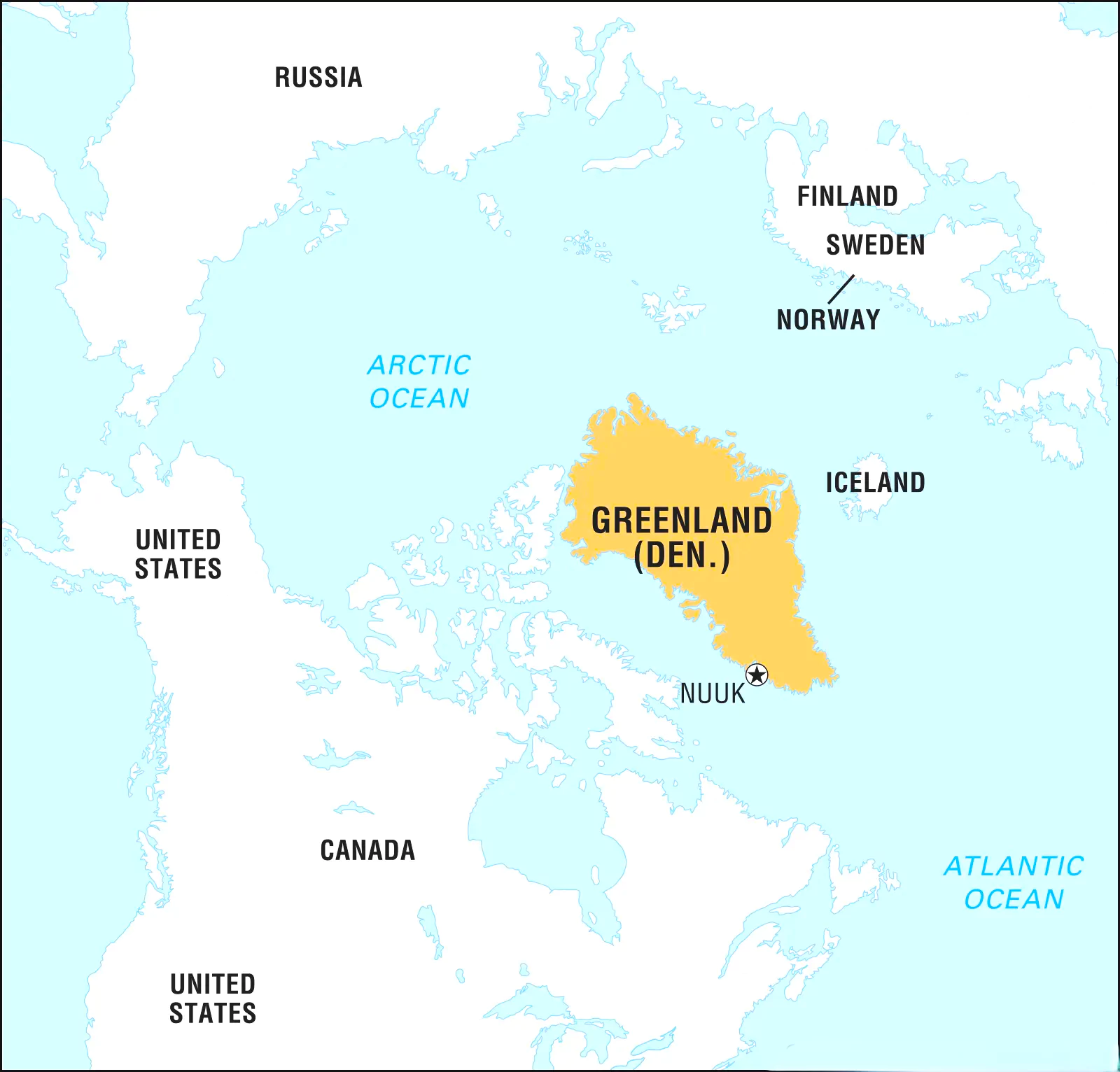
Context: The USA President elect Donald Trump over the years has desired to include the Territory of Canada, Greenland and Panama Canal as a part of the USA State for its trade and national security interests.

About Panama Canal

Panama Canal

  • The Panama Canal is an artificial 82-kilometer waterway in Panama that connects the Atlantic Ocean with the Pacific Ocean, cutting across the Isthmus of Panama.
  • Built: 
    • France began work on the canal in 1881 first but had to stop  in 1889 because of various problems.
    • The US took over the project in 1904 and opened the canal in 1914.
  • Control: Panama Canal is now managed and operated by the Panamanian government-owned Panama Canal Authority.
  • The USA Link: USA used to control the canal and surrounding Panama Canal Zone until 1977, until the Torrijos–Carter Treaties determined handover to Panama
    • After a period of joint American–Panamanian control, the Panamanian government took control in 1999.
  • The American Society of Civil Engineers has ranked the Panama Canal one of the Seven Wonders of the Modern World

About Greenland

Greenland

  • It is officially the world’s largest island that is not a continent and lies  in the North Atlantic Ocean.
  • Political Authority: Greenland is part of the Realm of Denmark but has its own extensive local government.
    • Greenland was a Danish colony until 1953, when it was redefined as a district of Denmark.
  • Population: Greenland has around 56,000 inhabitants.
    • It is divided into 3 subcultures based on regions,  Kalaallit (West Greenlanders), Inugguit (from Thule district), or Iit (East Greenlanders).
  • Capital: Nuuk


Hawaii’s Kilauea volcano

Context: Hawaii’s Kilauea Volcano, one of the most active volcanoes in the world, began erupting again in December 2024.

About Kilauea Volcano

  • Location: Kilauea is situated on the southeastern shore of Hawaii’s Big Island, within Hawaii Volcanoes National Park.
  • Type of Volcano: An active shield volcano.
  • Significance: The lavas of Kilauea, one of five volcanoes forming the island of Hawaii, contribute to building the Earth’s loftiest mountain.
  • Summit Caldera: Kilauea’s summit caldera is a large depression formed by the partial collapse of the volcano after most of its magma chamber was released.
  • Proximity to Mauna Loa:
    • Kilauea’s slopes merge seamlessly with Mauna Loa, another massive shield volcano.

Check Out UPSC CSE Books From PW Store

About Shield Volcano

  • Shield Volcano is a type of volcano with broad, gentle slopes formed by highly fluid basalt lava.
  • Features:
    • Unlike the conical peaks of composite volcanoes, shield volcanoes have elongated, dome-shaped profiles.
    • Eruptions are typically low in explosivity, often forming cinder cones and spatter cones at vents.
    • Explosions occur only if water enters the volcanic vent.
  • Examples: Hawaiian shield volcanoes such as Kilauea and Mauna Loa.

Aiming for UPSC?

Download Our App

      
Quick Revise Now !
AVAILABLE FOR DOWNLOAD SOON
UDAAN PRELIMS WALLAH
Comprehensive coverage with a concise format
Integration of PYQ within the booklet
Designed as per recent trends of Prelims questions
हिंदी में भी उपलब्ध
Quick Revise Now !
UDAAN PRELIMS WALLAH
Comprehensive coverage with a concise format
Integration of PYQ within the booklet
Designed as per recent trends of Prelims questions
हिंदी में भी उपलब्ध

<div class="new-fform">


    </div>

    Subscribe our Newsletter
    Sign up now for our exclusive newsletter and be the first to know about our latest Initiatives, Quality Content, and much more.
    *Promise! We won't spam you.
    Yes! I want to Subscribe.