Context: This article is based on the news “Stormy Monday in Chennai: Why are our cities so flood-prone?” which was published in the Live Mint. Cyclone Michaung has caused extensive floods causing severe damage to infrastructure and disruptions of livelihoods.
| Relevancy for Prelims: Urban Flooding, Cyclone Michaung, National Disaster Management Authority, and National Crisis Management Committee, Central Water Commission(CWC).
Relevancy for Mains: Disaster Management In India, Urban flooding in India, Causes, impacts, and solutions. |
Cyclone Michaung Highlights: Lives Lost, Cities Flooded
- Impact on lives: In just 35 hours, the cyclone poured over 43 cm of rain, causing severe flooding in Chennai.
- The cyclone led to eight deaths, and approximately 18,729 people including 6,000 within Chennai city limits, were moved to relief camps.
- Transport disruption: The Chennai airport built on the flood lanes of the Adyar River had to suspend operations affecting nearly 300 flights and stranding over 1,500 passengers.
- Southern Railway had to cancel several long-haul trains.
- Halt in communication services: It severely disrupted telecommunications in Chennai, halting essential communication networks including phone services, cell phone networks, and the internet.
- Economic Impact: The automotive and electronics hub of Sriperumbudur and Oragadam was forced to halt operations for two days.
- Economic activity was completely suspended in Chennai for two days due to closed airports, canceled trains, and flooded roads.
About Cyclone Michaung:
- It is a tropical storm, centered around 80 km southeast of Nellore and 120 km north-northeast of Chennai.
Reasons behind the intensification of Cyclone Michaung:
- Proximity to coast: The cyclone’s proximity to the coast greatly magnified its impact, reaching as close as 90 kilometers, a remarkably shorter distance compared to previous cyclones.
- Stagnant movement of cyclone: The cyclone slowed down to a mere 5 kph which normally moves at speeds between 10 to 18 kph.
- Intensification of cyclone while it was stationary: This intensification occurred close to the coast leading to heavy and prolonged downpours. The slow movement led to increased wetness, exacerbating the situation.
|
Also Read: Flash Floods
What are the causes behind the floods in Chennai?
- Lack of scientific planning: The city’s Master Plan and the Disaster Management Plan do not address the issue of urban flooding in a scientific manner.
- Chennai couldn’t evacuate the water in many parts of the city because of the poor quality of construction and the heavy rainfall.
- The rampant encroachment and choking of water bodies, particularly in the southern outskirts.
- Several farming and fishing towns and hamlets have been encroached by the city throughout its expansion leading to several environmental and ecological issues.
- Stormwater drains were built in the city to prevent urban flooding but it has been discovered that the construction of the drains was flawed.
- Topography: It is a very low-lying area and is more or less like a basin from which water cannot escape easily.
- Over the years, the expansion of the city with the construction of buildings in low-lying areas, led to stagnation of water as witnessed during the recent floods.
- Neglect of water recharge structures: The city’s recharge structures, such as ponds, lakes, tanks, and other wetlands, have been neglected, and the water’s natural flow has been altered.
- Decreasing marshland/wetland: The Marshland and wetlands of Chennai which act as natural buffers against flood water have become sites for waste disposal, housing, and commercial and industrial purposes.
- The rampant dumping of solid waste into the wetlands resulted in the leaching of effluents into the groundwater, causing significant pollution.
- The Ex-6,000-hectare area of Pallikaranai marshland, which acted as a floodwater drain, has shrunk to only 700 hectares.
What is Urban Flooding?
- Urban Flooding can be defined as ‘the submergence of usually dry areas by a large amount of water that comes from sudden excessive rainfall, an overflowing river or lake, melting snow or an exceptionally high tide’.
- In other words, the flooding of land or property in a built environment, especially in densely populated cities where rainfall exceeds drainage systems’ capacity, is known as urban flooding.
- As per the data from the government, over 17,000 people died due to floods and heavy rains in India between 2012 and 2021.
What are the reasons behind urban flooding in India?
- Climate Change: Global Climate Change is resulting in changed weather patterns and increased intensity rainfall events occurring in shorter periods.
- For Example: Urban flooding is significantly different from rural flooding as urbanization leads to developed catchments, which increases the flood peaks from 1.8 to 8 times and flood volumes by up to 6 times.
- Urban Heat Island Effect: According to the NDMA, the urban heat island effect has increased rainfall over urban areas.
- The hot air pushes the clouds carrying rain higher as they cross the urban heat island.
- Heat islands are urbanized areas that experience higher temperatures than outlying areas.
Institutional Framework and Arrangements for Urban Flooding:
- National Disaster Management Authority: NDMA is the apex body in India for disaster management.
- National Disaster Response Force: The DM Act 2005 has mandated the constitution of the NDRF for specialized response to a threatening disaster situation or disaster.
- The National Crisis Management Committee (NCMC): It comprises high-level officials of the GoI, headed by the Cabinet Secretary, who will also deal with specified major crises.
Early flood warning systems, India:
- Flood forecasts are issued by the Central Water Commission (CWC) in India.
- It provides a near real-time five-day advisory flood forecast on its web portal.
|
- Encroachment in Low Lying Areas: The original built-up area of Indian cities has expanded and new developments are taking place in low-lying areas of Indian cities and towns due to rising land prices and less availability of land in the cities.
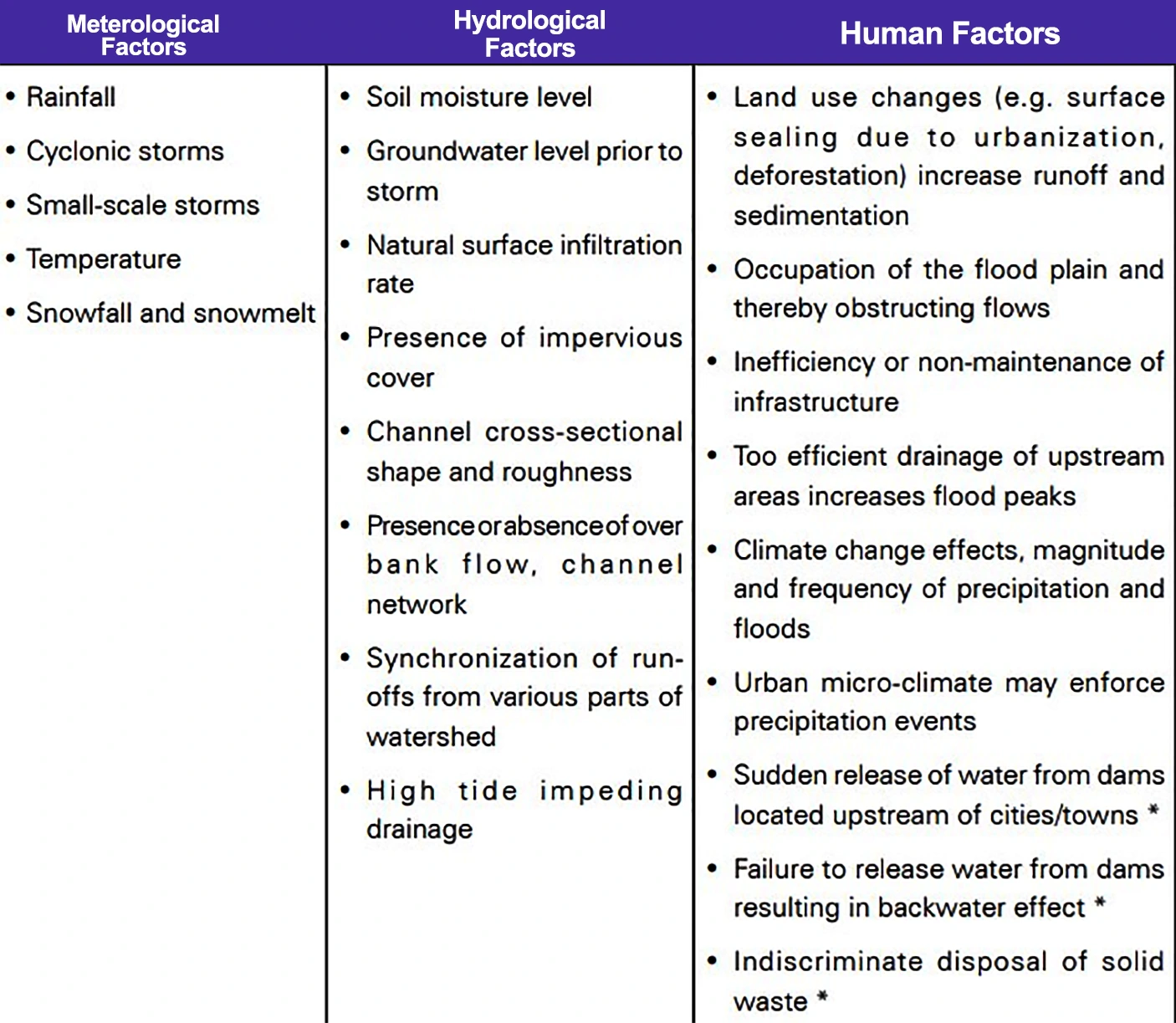 Most of the time, these developments take place on encroachments over lakes, wetlands, and riverbeds.
 - These encroachments have occurred without widening the natural drains. Thus, flooding occurs as the capacity of the natural drains is decreased.
- Sea Level Rise: Cities and towns that are near rivers, the ocean, interior cities, dams, and steep terrain are severely impacted due to sea level rise.
- For Example: Satellite observations have revealed that the rate of sea level rise is increasing and it rose by 0.11 inches from 2021 to 2022
- Faulty Drainage System: The urban areas lack adequate drainage infrastructure capable of handling heavy rainfall events.
- Poor planning and impermeable surfaces, such as buildings and highways, do not let water penetrate the ground and overburden the inadequate drainage systems.
- The issue is exacerbated by concretizing the drains and preventing the water from seeping into the ground.
- Urbanization: Rapid urbanization, both planned and unplanned, is responsible for flooding.
- Grey infrastructure which includes the flyovers, widening of roads, and urban settlements, contributes towards urban flooding in waterlogged areas.
Recent Urban flooding Incidents:
- Chennai in 2004 and 2015
- Delhi in 2002, 2003, 2009, 2010, and 2023
- Mumbai(2008)
|
-
- The recent floods in Gurugram and Bengaluru are examples of such planning failures.
- Construction of Highways Traversing Water Bodies Feeding Rivers and Streams: For example, the ‘Kisan Path’ in Lucknow-circular road has affected the Kukrail River and has blocked the drainage near the origin of the river.
- Improper Waste Disposal Practices Also Contribute To Flooding: Illegal development and encroachment on water bodies, urban green spaces, and small woods have been observed in many cities.
- This lowers the amount of water that can be stored and messes with the river’s natural flow, which increases floods after heavy rains.
- Velachery Lake in Tamil Nadu has disappeared due to sewage discharge.
What are the impacts of urban flooding?
- Tangible losses: The losses that can be measured physically and can be assigned an economic value. These losses can be direct or indirect.
- Direct: Structural damage to buildings, property damage, damage to infrastructure
- Indirect: Economic losses, Traffic disruption, and emergency costs.
- Intangible losses: Intangible losses include loss of life, secondary health effects, and infections or damages to the environment which are difficult to assess in monetary terms since they are not traded.
- Direct: Casualties, Health effects, ecological losses
- Indirect: Post-flood recovery process, mental damage to the people
Way forward for the urban flooding
- Adopting Sponge Cities Model: It is a model based on the monsoon climate and 2,000-5,000 years of experience and knowledge of adaptation.
- Climate Atlas: Every town and city must prepare its climate plan of action and a climate atlas with active participation of the people before a development plan.
- The vulnerable points must be identified, water contouring must be done, and the damage to water bodies or water channels must be checked.
- Capacity building must be done to adapt to flooding and other climate disasters. Sustainable Urban Planning: Cities need to embrace sustainable planning practices that consider the natural topography and hydrology of the region.
- Green spaces that can absorb excess water must be integrated into the plan.
- Flood-resilient infrastructure must be built that includes minimum engagement with the water contours.
| NDMA Guidelines on Urban Flooding:
Pre-Monsoon Phase:
- Preparedness: Planning for Disaster Reduction: Focus on plans to respond to a threat or occurrence of urban flooding.
- National Hydro-meteorological Network
- National Meteorological Network
- Local Networks for Real-time Rainfall data
- Doppler Weather radars
During Monsoon Phase:
- Early Warning: Measures to provide timely, qualitative, and quantitative warnings to urban flooding based on the intensity of rainfall.
- Effective Response and Management: Focuses primarily on emergency relief measures.
Post-Monsoon Phase:
- Restoration and Rehabilitation: Necessary measures to stabilize the vulnerable situation and restore the utilities.
|
- Improved Drainage Systems: Improved water management methods by enhancing waste collection and segregation must be practiced.
- A protocol for clearing the drains during summer months must be followed.
- Utilizing Geospatial Technology: Satellite data can help to digitize informal settlements and identify levels of vulnerability for flood protection strategies. geospatial technology should be used for flood vulnerability mapping.
- Further, natural water bodies should be strictly designed and maintained to ensure the free flow of excess water.
- Rainwater Harvesting: This should be included in all infrastructure constructions to ensure better water management.
- Along the sides of roads, bioswales should be constructed so that rainwater can percolate into the ground and flow toward them.
- Bioswales are landscape features that collect polluted stormwater runoff, soak it into the ground, and filter out pollution.
What are the best practices implemented globally to address urban flooding?
- Water-sensitive urban design (WSUD): Australia Water-sensitive urban design (WSUD) is an approach to planning and designing urban areas to make use of this valuable resource and reduce the harm it causes to our rivers and creeks
- Sustainable Urban Drainage Systems (SuDS) in the United Kingdom: Sustainable Urban Drainage Systems (SuDS) aim to reduce surface water flooding, improve water quality and enhance the amenity and biodiversity value of the environment
|
-
- Bioswales are similar to rain gardens but are designed to capture much more runoff coming from larger areas of impervious surfaces like streets and parking lots.
- Development of Blue-green Infrastructure: The term “Blue-green Infrastructure” refers to a network that uses infrastructure, ecological restoration, and urban design to connect people with nature to solve urban and climate problems.
- Blue denotes tanks and water bodies, while green denotes parks, gardens, and trees.
Conclusion:
The occurrence of urban flooding is exemplified by the recent challenges faced by Chennai City after Cyclone Michaung. We need better plans for cities, stronger buildings, and good ideas from around the world to avoid these disasters and keep people safe.
 7 Dec 2023