Context:
This article is based on the news “Clear and present danger in the Himalayas” which was published in the DownToEarth. Recently, the Supreme Court approved Shimla’s first development plan “Shimla Development Plan 2041”. This approval highlights the controversy of increasing vulnerability and challenges the Himalayan regions face.
AMRUT: Atal Mission for Rejuvenation and Urban Transformation
- Its purpose is to ensure that every household has access to a tap with assured supply of water and a sewerage connection; increase the amenity value of cities by developing greenery and well maintained open spaces (parks), and reduce pollution by switching to public transport or constructing facilities for non-motorized transport (e.g. walking and cycling).
|
Absence of Master Plan For Himalayan Cities, Posing Threat to Himalayan Ecosystem
- Lack of Master Plan in Himalayan Cities: An analysis of data with the Town and Country Planning Organisation (TCPO) under the Union Ministry of Housing and Urban Affairs shows that none of the tier 1 cities (with a population of over 0.1 million as per the Census 2001) or metro cities (with a population of more than 1 million) in the 13 Himalayan states have master plans to regulate development.
- Plan under AMRUT Scheme: As of January 22, 2024, only eight cities have their draft master plans ready under the Union government’s Atal Mission for Rejuvenation and Urban Transformation (AMRUT) scheme– Kargil and Leh in Ladakh, Kullu (Himachal Pradesh), Shillong (Meghalaya), Itanagar (Arunachal Pradesh), Kohima and Dimapur (Nagaland), Imphal (Manipur) and Aizawl in Mizoram.
Need For the Development Plan
- Expert Views on Disaster Risk Plan: Disasters are glaring consequences of a city that is at a high risk of earthquake and landslides and has grown haphazardly in the absence of a master plan or comprehensive development guidelines.
About Shimla Development Plan 2041

- Prepared by: The Town and Country Planning Department of Himachal Pradesh, based on the city’s potential as a tourist destination and its capacity to accommodate future residents and floating populations.
- A Long Term Planning: It lays out a blueprint for sustainable growth of the Himalayan city and its fringes, also known as Shimla Planning Area, over the next two decades.
- Considered Estimate: The document estimates that by 2041, Shimla will be home to 498,000 people and host another 127,000 floating population, mostly tourists—this is a 60% jump from the total population staying and visiting the city in 2021.
Concerns Are Associated With Shimla Development Plan 2041
-
High Floor-Area Ratio (FAR):
- The new FAR guideline in the Development Plan has a higher base FAR, which will lead to more construction in the already congested areas.
- FAR is the most important component of building by-laws, because it directly determines the dwelling density, household density as well as population density in a city.
- Currently the FAR in core and non-core areas of Shimla is 1.5 and 1.75. But the development plan aims to keep the base FAR at 1.75.
-
No Focus on Climate-Resilient Plans:
- In a warming world, cities need climate-resilient master plans by integrating adaptive and mitigative measures. However, this plan falls short on this.
-
No Suitability:
- The development plan is not suitable for the hill town. Being a mountainous region, the zonation should be made from the perspective of geology. Given the fragility of the region, the authorities should have created just construction and no-construction zones.
-
Not in Accordance with the Guidelines of NGT:
-
- The Development Plan was not in accordance with the NGT recommendations for which the tribunal declared the development plan “illegal”.
Approval by the Apex Court
- The SC stated that the Shimla Development Plan 2041 appears to have “sufficient safeguards to balance the need for development while taking care of and addressing the environmental and ecological concerns (sustainable development)”.
Himalayan Region: A Fragile Ecosystem
- Statistic: The Himalayan region accounted for 44% of all the disasters reported in India.
- A Severe Threat: Its various impacting factors form a setting extremely susceptible to natural disasters like earthquakes, landslides, subsidence, floods, snow avalanches and even cloud bursting and forest fires.
The Significance of the Himalayas and its Importance For India
Himalayas comprises the most dominating geographic feature of India. No other mountain range anywhere in the world has affected the life of people and shaped the destiny of a nation as the Himalayas have in respect of India.
-
Climatic Influence:
- Blessed with the high altitude, length and location, the Himalayas effectively intercept the summer monsoons coming from the Arabian Sea and Bay of Bengal causing precipitation in the form of rain and snow.
- They prevent the cold continental air masses of Central Asia from entering into India.
- Himalayas are responsible for splitting the jet stream into two branches and these in turn play a significant role in bringing the Monsoon to India.
-
Defence:
- The Himalayas have been protecting India from outside invaders since early times thus serving as a defence barrier. However, the Chinese aggression in October 1962 has reduced the defence significance of India. In spite of the advancement in modern warfare technology, the defence role of the Himalayas can not be neglected.
-
Source of Rivers:
-
- Himalayas act as a huge reservoir of water for the north Indian rivers like the Ganges, Indus, Brahmaputra, etc. Snow melt in summer provides water to these rivers even during dry season and hence these are perennial rivers.
-
Fertile Soil:
- Himalayas are the formation of the sediments deposited in the Tethys sea, which is carried by the Himalayan rivers and deposited in the northern plain in the form of the fertile soil, making the plain one the most fertile land of the world.
-
Hydroelectricity:
-
- Deep valleys in the Himalayas are the best location for the construction of the dams and offer several sites that are suitable for the production of hydroelectricity.
-
Forest Wealth:
- The Himalayan Ranges are very rich in forest resources. In their rising altitude, the Himalayan ranges show a succession of vegetal cover from the tropic to the Alpine.
-
Agriculture:
- Himalayan slopes are terraced for cultivation. Rice is the main crop on the terraced slopes. Tea is unique and can be grown on the hill slopes only. Apples, peaches, walnuts, cherries, apricots, etc are also grown in the Himalayan region.
-
Tourism:
- It provides a huge scope of tourism due to its scenic beauty and healthy environment.
-
Cultural and Spiritual:
- Himalaya is the abode of the Gods. Apart from its beautiful scenery, Himalayas are proud of being studded with sanctified shrines. Examples- Kailash, Amarnath, Badrinath, Kedarnath, Vaishnu Devi, etc.
- Himalayas are spiritual centres of numerous cultures and religions, including Hinduism, Buddhism, and Jainism.
-
Minerals:
- The Himalayan region contains many valuable minerals such as coal, copper, lead, zinc, nickel, cobalt, antimony, tungsten, gold, silver, limestone, etc.
- However, mineral extraction from the Himalayan ranges is not feasible due to its complex terrain.
-
Geological Insight:
- Studying the Himalayas provides insights into the Earth’s tectonic forces and helps scientists to understand the dynamics of mountain building.
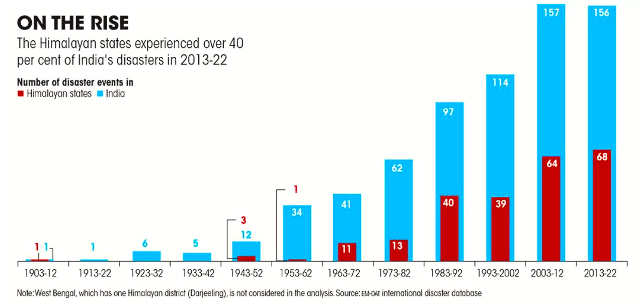
Factors Responsible For Himalayan Calamities
- Erosion: Being the youngest mountain range in the world, Himalayas are highly prone to erosion.
- Bank erosion is also extensive wherever the rivers take a sinuous course.
- High Seismic Zone: Due to continuous upliftment of the mountain, the region falls in a very high seismic zone, and its rivers cut the rocks deeply.
- Severe Climatic Events: Rainstorms and cloud bursts.
Concerning Data
- An analysis of data available on the EM-DAT international disaster database: It shows that the Himalayan regions—Ladakh, Jammu and Kashmir, Himachal Pradesh, Uttarakhand, Arunachal Pradesh, Manipur, Meghalaya, Mizoram, Nagaland, Sikkim, Tripura and Assam (except Darjeeling, West Bengal) account for 18% of the India’s geographical area, but have experienced 35% of the major disasters over the last 110 years.
| EM-DAT is the only database that provides such disaster information since the 1900s, it records only major disasters, defined as those that have either recorded 10 or more deaths, affected 100 or more people, led to the declaration of a state of emergency, or called for international assistance. |
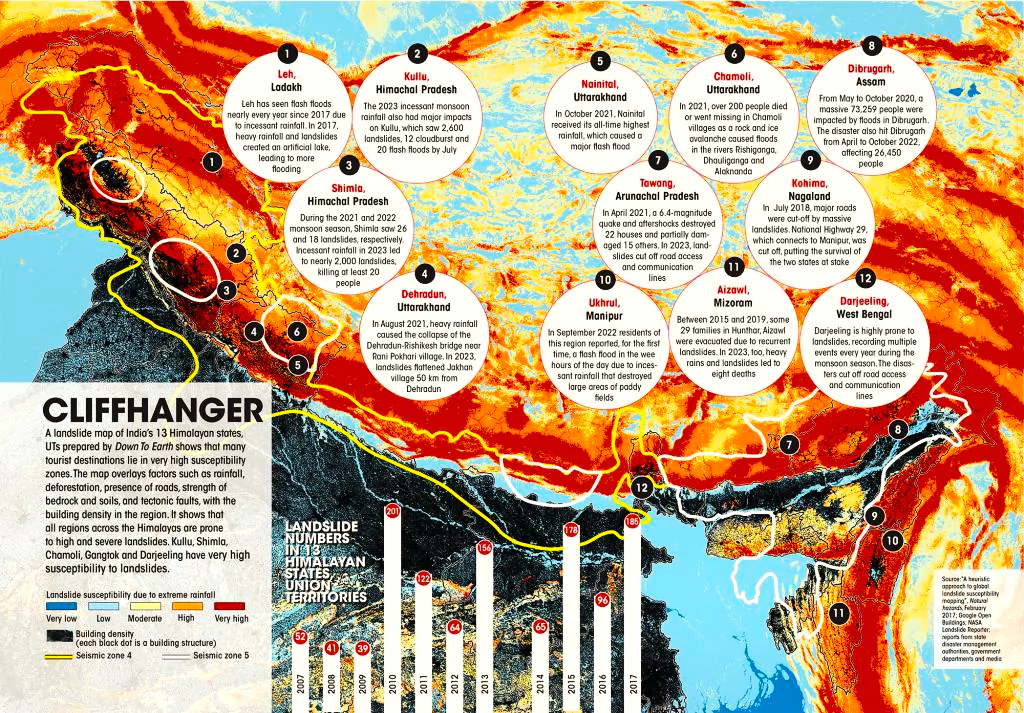
- In recent decades, these disasters are occurring more frequently and getting more severe, causing a significant loss of life and damage to property. The last decade (2013-2022) saw the highest number of disasters at 68 and they accounted for 44% of all the disasters reported in India.
- The National Center for Seismology (NCS): This Centre, under the Union Ministry of Earth Sciences, revealed that the Himalayan states have recorded 2,687 earthquakes between 2009 and 2021, but the majority of the events were of low intensity.
| NCS is the nodal agency of the Government of India for monitoring earthquake activity in the country. It maintains the National Seismological Network of 160 stations each having state of art equipment and spreading all across the country. |
-
- While no systematic study has been undertaken to ascertain the reasons for such growing instances of disasters.
Disasters and Challenges Experienced in the Himalayan Region
-
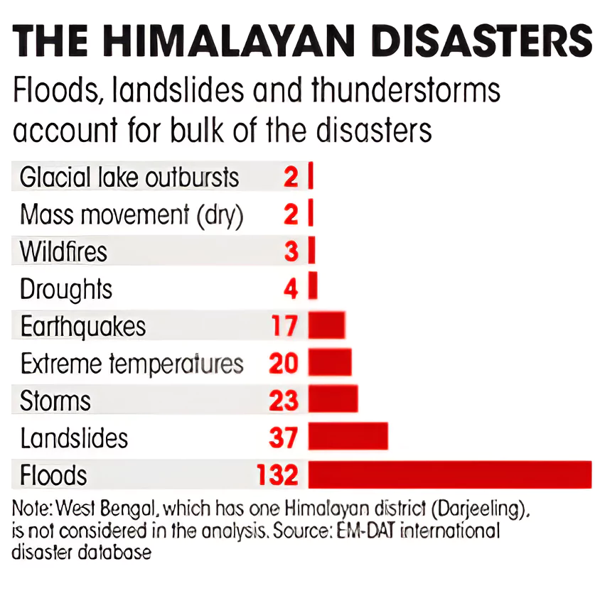
- Floods are the most common type of disaster in Himalayan region, accounting for 132 of the 240 disasters recorded since 1903.
- Flood is followed by landslides (37), extreme temperature (20) and earthquakes (17).
- Floods (36) have remained the most common disaster type even in the last decade (2013-2022), followed by thunder, cyclonic storms, landslides and earthquakes.
-
Melting of Himalayan Glaciers:
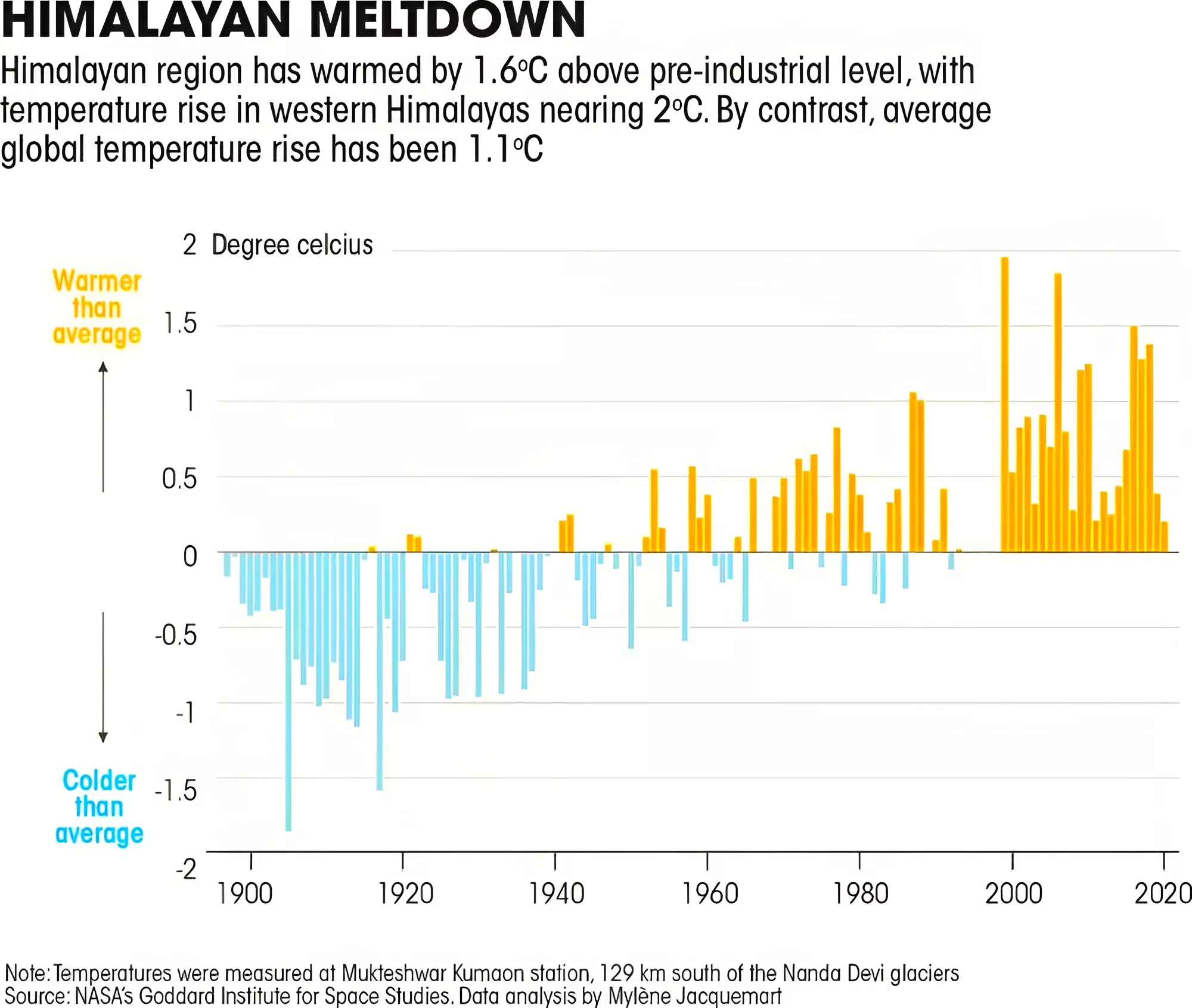
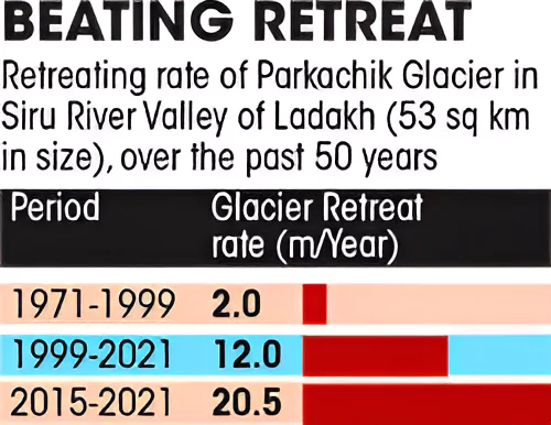
- It is the worst long-term damage. The rise in average surface temperatures in the Himalayas has exceeded 1.6°C and is causing the Himalayan glaciers to melt rapidly, which are then retreating at an accelerating rate.
- Reason: One of the major factors causing glaciers to melt is the emission of black carbon aerosols into the atmosphere as black carbon absorbs more light and emits infrared radiation that increases the temperature.
-
High Amount of Glacial Lakes:
- The ice-melt from the glaciers is forming glacial lakes across the Himalayan range. The increasing frequency and ferocity of cloudbursts is causing these lakes to overflow or burst their banks and cause havoc downstream.
-
- Torrent: The first such catastrophe occurred in 2013, above Kedarnath. The torrent that raged down the Bhagirathi claimed, officially, 6,074 lives.
- A similar “lakeburst” occurred at Chamoli in Uttarakhand in February 2021 and caused havoc to infrastructure along the Alaknanda.
- In February of 2023, Joshimath started sinking as its topsoil had been fatally loosened by the rising incidence and ferocity of cloudbursts, indiscriminate construction along the banks of the Alaknanda River, and the disturbance of the Earth’s crust by a hydropower project of the National Thermal Power Corporation (NTPC).
 The most recent glacial lake burst occurred in Sikkim on October 4, 2023, and claimed more than 400 lives.
-
Glacier Retreat:
- In the west of Himachal Pradesh and Ladakh, glaciers are receding in the Hindu Kush Himalayan range by 5.9 to 6.7 m every year.
- Growth of Invasive Species: With rise in temperatures, new habitats become available for invasive species, which disrupt the delicate balance of ecosystems and threaten the survival of native species.
Government Initiatives For Protection to the Himalayan Region
- National Mission on Sustaining Himalayan Ecosystem
- SECURE Himalaya Project
- Mishra Committee Report, 1976: The committee recommended placing restrictions on heavy construction work, blasting or digging to remove boulders for road repairs and other construction, and felling of trees in the region.
- NGT Direction: In July 2018, the NGT directed the Union Ministry of Urban Development and Union Environment Ministry to initiate steps to undertake carrying capacity studies in all states and Union Territories, which would assess the burden on eco-sensitive zones in terms of air, water, habitat, biodiversity, land, noise and tourism.
|
Way Forward to Protect Himalayan Region
Supreme Court Initiative: In August 2023, the Supreme Court mooted a re-evaluation of the load-carrying capacity of hill towns and cities, for which the Centre has proposed forming a 13-member technical committee. There is a five-point agenda to consider:
-
Understand Environmental Stress Factor:
- Need to understand the effect of slope, drainage and cover (high vegetation and forest land) on the stress that an area can take and then accordingly authorities must declare zones and subzones fit or unfit for construction.
-
Assessing Climate Exposure and Vulnerabilities:
- Projections and simulations are needed to gauge climate exposure and map vulnerable areas as with the rise in extreme weather events, the scale of loss and damage is high.
-
Mainstreaming Risk and Impact Assessments:
- Development regulations must take these into consideration, by mainstreaming risk-likelihood and cumulative impact assessments. Since, the development works are soaring and have severe impacts such as forest fragmentation, change in river course, biodiversity loss etc.
-
Enhancing Adaptive Capacity and Community Involvement:
- By augmenting services and infrastructure, the adaptive capacity can be improved while prioritising solutions with lesser environmental footprint, and by roping in communities. Since, the populations of hill towns increase, their capacity to adapt to climate change shrinks.
-
Tourism and Resource Management:
-
- By focusing on Sound tourism and resource management strategies, including for traffic, water and waste as hilly areas see a large influx of floating population.
Other Important Steps that Need to be Taken
- Technological Advancements: The accuracy, precision and reliability of meteorological services in India have improved a great deal in recent years and need to be updated more.
- More Financial Support: The need now is for additional budgetary provisions to monitor glaciers and glacial lakes, for the early draining of excessive water, and much better forecasting and forewarning of disasters, so that preventive measures can be taken and timely evacuation, relief, and resettlement and rehabilitation can be started.
- Alternatives for Fossil Fuels: There is a need to reduce the demand for fossil fuels and rapidly replacing the energy source with renewables.
- Transboundary Collaboration: Himalayan countries need to build an international network that will monitor and give early warnings.
- Education and Awareness: People need to be made more aware of the geological vulnerability and ecological fragility with associated laws and regulations to protect it.
- Action by Local Governments: Local Governments can play a more proactive role while granting approval to buildings and other related laws.
Also Read: Interim Budget 2024-2025
| Prelims PYQ (2017):
Consider the following statements:
1. In India, the Himalayas are spread over five states only.
2. Western Ghats are spread over five states only.
3. Pulicat Lake is spread over two States only. Which of the statements given above is/are correct?
(a) 1 and 2 only
(b) 3 only
(c) 2 and 3 only
(d) 1 and 3 only
Ans: (b) |
![]() 29 Feb 2024
29 Feb 2024


 The most recent glacial lake burst occurred in Sikkim on October 4, 2023, and claimed more than 400 lives.