NITI Aayog released the 2025 report “Water Budgeting in Aspirational Blocks” to operationalise block-level, data-driven water planning through the Varuni web platform for achieving Water Vision@2047.
Aspirational Block Programme (ABP)
- Launch: Launched by the Hon’ble PM in January 2018, the Aspirational Districts Programme (ADP) aims to quickly and effectively transform 112 most under-developed districts across the country
- Objective: To raise the living standards of its citizens and ensure inclusive growth for all – “Sabka Saath Sabka Vikas aur Sabka Vishwas”.
- Champions of Change: The performance of the Aspirational Districts is available in the public domain portal named “Champions of Change”
|
- The Application for Water Budgeting has been piloted in 18 aspirational Blocks across varied state/ agro-climatic zones in India.
- A comparative analysis of the water budgets across the 18 Blocks is also presented.
What’s Water Budgeting?
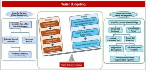
- A scientific accounting framework that quantifies all water inflows, outflows, storage and transfers within a defined geography to assess demand–supply balance.
Key Terminologies
- Crop Water Requirement (CWR): The amount of water needed by a crop to meet its needs for optimal growth and yield.
- It is a key pillar in understanding the water requirements of the agriculture sector.
- INDIA-Groundwater Resource Estimation System (IN-GRES): A web-based application developed by CGWB and IIT-Hyderabad for the assessment of Groundwater resources.
- It provides critical information for water budgeting at the block level, including annual Groundwater extraction and Groundwater development status.
- Strange’s Table Method: An empirical hydrological modelling technique widely used to provide percentages for converting rainfall into runoff based on the classification of catchments as Good, Average, or Poor.
- Runoff: Rainwater runoff is the flow of water that does not get absorbed into the ground, instead running off the land and flowing into surface water bodies like streams, rivers, and lakes, or into storm drains and sewers
- Catchments: It is the geographical area from which rainfall naturally flows into a common outlet such as a river, stream, tank, or reservoir.
|
- Core Components:
- Demand: Human (55/150 Litres Per Capita Per Day (LPCD) norms), Livestock (ICAR norms), Agriculture (CWR 0.50 m), Industry.
- Supply: Surface water (Ponds, tanks, reservoirs), Groundwater (IN-GRES data), Rainfall-based runoff (Strange’s Table), and Inter-basin transfers
- Balancing supply and demand: The data is used to compare the total water available against the total water required.
- This comparison can highlight whether there is a surplus or a deficit
- Significance
- Ensures scientific planning at block/village level.
- Enables early identification of deficits and hotspots.
- Facilitates climate-resilient water management.
- Supports integrated resource use across sectors like agriculture, drinking water & industry.
Key Highlights of the Report
- Introduction of Varuni Platform: It is an automated web application which will help to quantify the gap between water demand and supply and identify the hotspots in water consumed across sectors.
- Role of Indo-German WASCA Project: The Indo-German collaboration (GIZ India–MoJS–MoRD) developed a scientific and user-friendly block-level water budgeting framework, which evolved into the Varuni Web Application.
- The platform removes manual calculation errors and standardises water budgeting methodology across India.
- Potential: The application enhances accessibility to required datasets and has potential for raising awareness among stakeholders about water management, serving as a valuable tool for addressing India’s water security challenges through informed, data-driven planning.
- Dataset for Water Budgeting: It uses publicly available datasets to keep the method simple, scalable, and administratively implementable at the Block level, chosen as the most practical planning unit.
- Rationale for a Simplified Method: Globally (Australia, Brazil, Canada, Italy, UAE, USA), water budgets rely on advanced satellite or remote sensing inputs.
- However, these methods are too complex for field-level application.
- This necessitated the creation of a simple, automated, web-based approach (Varuni) that uses authentic public datasets for real-time budgeting.
- Comprehensive Piloting Across India: The pilot covers 18 Aspirational Blocks across 11 States & 8 agro-climatic zones
- It ensures representation of highly diverse physiographic settings like Himalayan cold deserts, coastal belts, alluvial Gangetic plains, Bundelkhand’s hard-rock terrains, and western arid zones.
- This diversity allows comparative understanding of region-specific water stress patterns.
- Comprehensive Demand-Side Framework:
- Human demand: Calculated using 55 Litres Per Capita Per Day (LPCD) (rural) & 150 Litres Per Capita Per Day (LPCD) (urban), with 20% conveyance loss factored. Annual population projections use decadal growth of 25%.
- Livestock demand: Based on ICAR-standard coefficients for each species; crucial given that livestock contributes significantly to rural household economies (e.g., Nirmand has >31,000 animals).
- Agricultural demand: Uses crop water requirement fixed at 0.50 m based on national averages, covering nearly 70–90% of block water needs in most regions.
- Industrial demand: Incorporated through manual block-level inputs due to data gaps.
- Comprehensive Supply-Side Framework: The report integrates multiple supply sources like surface water (ponds, tanks, reservoirs), groundwater (IN-GRES data), and inter-basin transfers (canals, drinking water grids).
-
- Runoff estimation uses Strange’s Table to classify catchments into Good/Average/Poor.
- Surface water availability is derived from the first nationwide Water Bodies Census covering 24.24 lakh structures, with ponds forming 59.5% of the total.
- Groundwater extraction status is mapped as Safe/Semi-critical/Critical/Over-exploited for each block.
- Water Transfers: Includes canals, irrigation projects, JJM pipelines, and industrial supply systems, captured through district/block-level inputs (since not fully available publicly).
- Region-Specific Outcomes:
- Highest Deficits: Namchi (94%), Gangiri (60%), Baldeogarh (53%), Andimadam (42%).
- Himalayan Blocks (Nirmand, Rupsho) show surplus water due to abundant glacier/spring-fed sources but limited irrigated area.
- Gujarat’s Kukarmunda, despite the massive Ukai Dam capacity (3,90,514 ha.m), still draws 96% of water from groundwater—indicating behavioural and infrastructural dependence.
- Bundelkhand blocks show highest water stress due to hard-rock aquifers and low storage potential.
Systemic Water Management Challenges
- Gangetic Plains Overdependence: Blocks such as Fatehpur, Gangiri, Kotwali, Nindaura show high agricultural usage and groundwater dependence.
- Many blocks face chronic irrigation dominance (rural areas) where agriculture uses 80-90% of water water demand (e.g., Fatehpur = 88%, Kukarmunda = 90%).
- This leaves the negligible buffer for domestic and ecological needs.
Stage of Groundwater Extraction (SoE)
- An indicator that reflects the Groundwater situation in a particular block.
- It is calculated as the ratio of total Groundwater extraction for all uses to the annual extractable Groundwater.
- Blocks are categorised based on their SoE as ‘Safe’ (< 70%), ‘Semi-critical’ (> 70% and <= 90%), ‘Critical’ (> 90% and <= 100%), or ‘Over-exploited’ (> 100%).
|
- Over-extraction of Groundwater: Blocks like Kotri and Abu Road are in the over-exploited category (>100%), signalling unsustainable withdrawals.
- Even Safe blocks (e.g., Kukarmunda: 68.7% SOE) show very high dependence despite large surface-storage availability.
- Under-utilisation of Surface Water Bodies: Fatehpur uses <5% of its harvested 2,116 ha.m stored water for productive use. Kukarmunda hardly uses Ukai Dam for local irrigation, depending instead on groundwater. This highlights infrastructural inefficiency and poor canal network utilisation.
- Ecological Vulnerabilities:
- Coastal Region Stress: Blocks like Gangavaram and Andimadam experience low irrigation coverage, salinity intrusion, and high reliance on surface sources, requiring groundwater quality protection and demand management.
- Himalayan & Cold Desert Vulnerabilities: Blocks like Namchi, Nirmand, Rupsho depend on spring–glacier systems.
- Despite surplus in Nirmand & Rupsho, Namchi faces a large deficit (94%), highlighting limits in spring discharge and the urgency for conservation.
- Acute Scarcity in Arid/Semi-Arid Zones: Rajasthan & Bundelkhand blocks face chronic scarcity, high evaporation, low recharge, and overextraction (>100%) in Kotri & Abu Road.
- Baldeogarh shows the worst deficit (-11,237.5 ha.m)
- Data Gaps and Monitoring Challenges:
-
- Absence of industrial water-use data.
- Lack of inter-basin transfer quantification in public datasets.
- Missing datasets for spring discharge, glacier melt, and small streams. These inhibit full hydrological closure at the block scale.
- Inadequate Community-Level Water Governance: Despite JJM – Jal Jeevan Mission and PMKSY – Pradhan Mantri Krishi Sinchayee Yojana mechanisms, water user associations, Pani Samitis, and local monitoring remain weak, limiting implementation of budgeting recommendations.
JJM – Jal Jeevan Mission
- A Government of India mission launched in 2019 to provide Functional Household Tap Connections (FHTCs) to every rural household, ensuring 55 LPCD safe drinking water through piped supply and community-led water management.
PMKSY – Pradhan Mantri Krishi Sinchayee Yojana
- A national programme launched in 2015 to achieve “Har Khet Ko Pani” by expanding irrigation coverage, improving water-use efficiency through micro-irrigation (“Per Drop More Crop”), and promoting watershed development for drought-proofing.
|
Key Action Points
- Water Deficit Prioritisation: Severe deficits identified in Namchi (94%), Gangiri (60%), Baldeogarh (53%), Andimadam (42%), Abu Road (41%), Kukarmunda (37%), Kotri (21%), Chhaigaon Makhan (14%), Kotwali (11%) demand urgent, block-specific interventions
- Strengthen Irrigation Efficiency: Introduce micro-irrigation, crop diversification, and regulated pumping in blocks where irrigation constitutes >80% demand.
- This is crucial in Gangetic (Fatehpur), plateau (Chhaigaon Makhan) and semi-arid (Kotri) regions.
- Region-Specific Water Strategies:
Dhara Vikas Model in Sikkim
- It is a government initiative launched in 2008-2009 to revive drying springs by implementing spring-shed development techniques, primarily for rural water security.
- It combines scientific methods like hydrogeological studies and GIS mapping with traditional community knowledge to improve groundwater recharge through practices such as building trenches and ponds to slow surface runoff and increase percolation
|
-
- Coastal blocks: Promote artificial recharge, salinity barriers, conjunctive use, and protection of freshwater lenses.
- Bundelkhand: Scale up check dams, percolation tanks, and watershed treatments to improve hard-rock aquifer recharge.
- Himalayan blocks: Expand spring-shed management akin to Sikkim’s Dhara Vikas model to safeguard drying springs.
- Arid regions (Rajasthan): Prioritise canal network rehabilitation and aquifer recharge through appropriate zoning.
- Overexploitation Control: Blocks where groundwater extraction exceeds 100% (Kotri, Abu Road) must implement:
-
- Groundwater abstraction regulation
- Artificial recharge structures
- Pumping control and Community monitoring
- Optimise Surface Water Usage: Many blocks under-utilise available surface water; hence:
- Rehabilitate canals, tanks, lift irrigation systems.
- Enable equitable distribution via command-area development.
- Promote piped conveyance to reduce seepage.
- Groundwater Regulation and Recharge:
- Enforce groundwater abstraction controls in over-exploited blocks.
- Mandate recharge pits, contour trenches, and farm ponds.
- Integrate IN-GRES data with local monitoring stations for real-time tracking.
- Strengthen Varuni-Based Planning: Integrate Varuni outputs into JJM Village Action Plans, PMKSY-WDC works, MGNREGS water conservation, District Irrigation Plans, and local governance-led monitoring.
- Community-Centric Water Governance: Empower Gram Panchayats to maintain water logs, regulate withdrawals, and perform seasonal water audits.
- Encourage behavioural shifts towards water conservation through IEC programmes.
Conclusion
Water budgeting enabled through Varuni provides a scalable, scientific foundation for India’s transition to climate-resilient, equitable and sustainable water security by 2047.


 20 Nov 2025


.png)


 Current Affairs


 GS Foundation
 Optional Course
 Combo Courses
 Degree Program