Context
According to an analysis of data released by the Central Water Commission (CWC), at least 13 east-flowing rivers between Mahanadi and Pennar have no water at the moment.
- They include Rushikulya, Bahuda, Vamsadhara, Nagavali, Sarada, Varaha, Tandava, Eluru, Gundlakamma, Tammileru, Musi, Paleru and Munneru.
Central Water Commission (CWC): It is a premier Technical Organisation in the field of water resources.
- Mandate: It has been established for promoting integrated and sustainable development for the management of water resources.
- Nodal Ministry: Ministry of Jal Shakti
|
Enroll now for UPSC Online Course
River Systems: Socio-Economic Impact & Water Shortages in India

- Drainage of Rivers: The rivers drain directly into the Bay of Bengal after flowing through the states of Andhra Pradesh, Telangana and Odisha through an area of 86,643 square kilometre (sq km).
- River Systems in India: The river systems in India provide water for irrigation, drinking and domestic consumption as well as cheap transportation and electricity.
- Water shortage in the river basins gravely affects the socio-economic conditions, livelihoods and agricultural activity of the region, which is dependent on the rivers for water supply.
Status of Indian River Basins
- States with Largest Deficit: According to the India Meteorological Data (IMD), Andhra Pradesh and Telangana have experienced ‘large deficits’ (65 and 67 percent respectively) in rainfall since March 1.
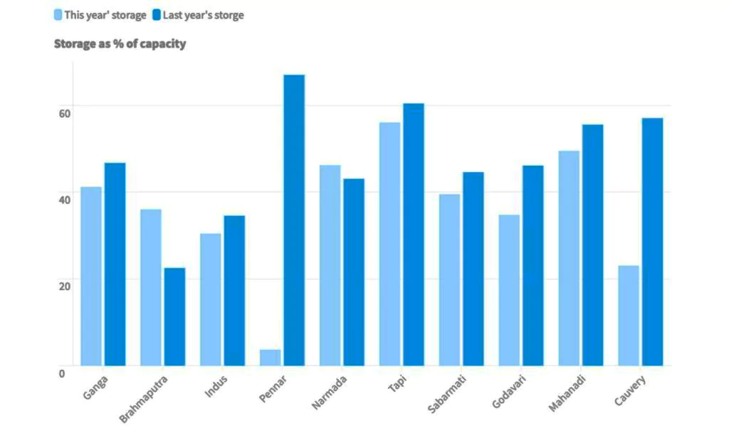
- Reduction in Water Storage: The Ganga basin, which is the largest basin in the country, recorded water storage at less than half (41.2 percent) of its total capacity.
- Narmada, Tapi, Godavari, Mahanadi and Sabarmati river basins recorded 46.2 percent, 56 percent, 34.76 percent, 49.53 percent and 39.54 percent storage relative to their capacities, respectively.
- The east flowing rivers between Pennar and Kanyakumari have just 12 percent storage and a departure of over 50 percent with respect to an average of ten years.
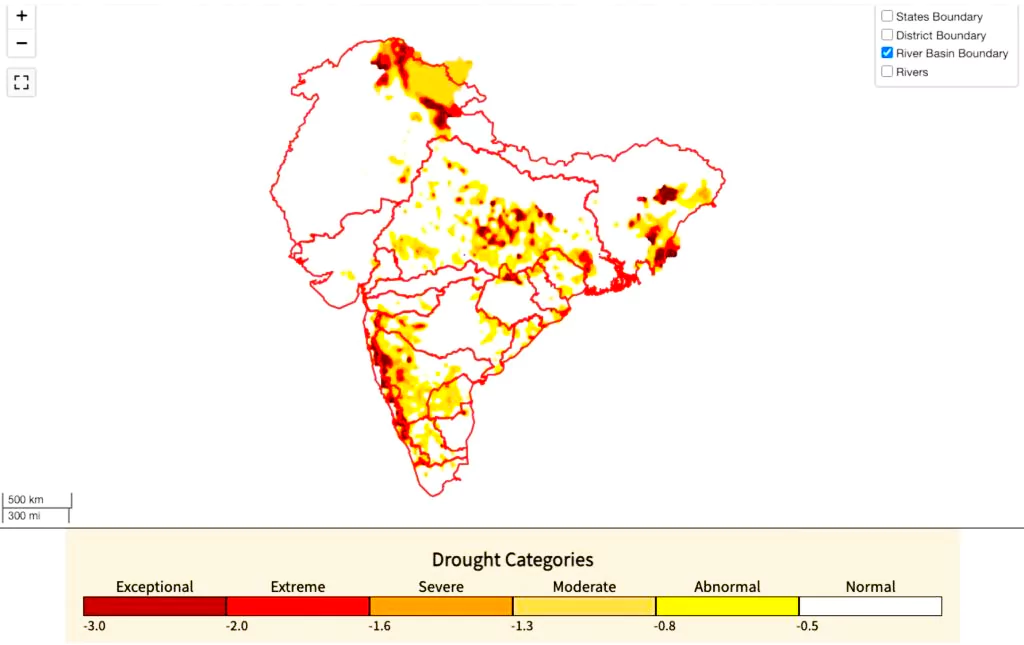
 Drought Condition Within River Basins: According to India Drought Monitor, several areas within the boundaries of the river basins have been experiencing ‘extreme’ to ‘exceptional’ drought.
-
- At least 35.2 percent area in the country is under ‘abnormal’ to ‘exceptional’ degrees of drought currently.
- States like Karnataka and Telangana are facing drought and drought-like conditions because of rainfall deficits, which also left the country’s major reservoirs dry.
- Reduction in Live Storage Capacity: The live storage capacity in India’s 150 major reservoirs has dropped to 36 per cent of their total capacity, with at least six reservoirs recording no water storage.
- There are at least 86 reservoirs in which the storage is either 40 per cent or below.
- Most of these are in the southern states and in Maharashtra and Gujarat.
Reasons for Water Crisis in India
- Climate Change: Higher temperatures, frequent extreme weather events, and changed patterns of precipitation lead to disruption in natural flow of water reducing water availability and causing drying.
- Indiscriminate Construction of Dams: Natural river flow patterns are changed when dams, reservoirs, and diversions are built for hydroelectric production, irrigation projects, and urban water supply.
- The connectivity of groundwater with the river is being broken by concrete structures resulting in drying of most of the rivers.
- Deforestation and Land use Changes: Widespread deforestation causes soil erosion, decreased groundwater recharge, and altered Hydrological Cycle.
- Inefficient Water Management Practices: This includes excessive extraction for irrigation, industrial use, and domestic consumption.
- Groundwater Depletion: Over-exploitation of groundwater, prolonged droughts and unsustainable groundwater extraction techniques leads to reduced base flow of rivers.
- Sand Mining: The excessive extraction of sand from the river disturbs the natural balance, impacting aquatic plants and microorganisms and food chains in the riverine system.
- Ex- Extraction of sand from the Yamuna has led to a decline in groundwater levels.
- Pollution: River ecosystems are weakened by pollution-induced stress, which increases their vulnerability to drying out during dry spells.
- River waters are contaminated by pollution from untreated sewage, industrial waste, and agricultural runoff, which lowers water quality and damages aquatic ecosystems.
Measures Needed to Address Issue of Drying Rivers
- Restoration of Rivers: This includes:
- Identification and marking of encroachment on the two kilometer-buffer on both sides of the river(s) on the drainage map using revenue/cadastral maps.
- Identification of the critical stretch which needs immediate attention such as channel obstruction, channel fragmentation, etc.
- Marking of origin points of a river/stream as well as confluence points in the respective districts for special conservation zoning/priorities.
- Traditional Water Conservation Techniques: The regeneration of ponds, reservoirs, and traditional water systems can save ten times more water, and at a fraction of the cost.
- Restoration, rejuvenation and renovation of existing water bodies needs to be given high priority in water scarce areas.
- Technological Innovations: Advanced irrigation techniques such as drip and sprinkler irrigation to water-efficient appliances and smart water management systems, technology offers solutions to optimize water usage and minimize wastage.
- Remote sensing and GIS technologies can aid in monitoring water resources and implementing targeted interventions.
- Creating Inventories and Geo-Mapping of Water Bodies: Inventory of water bodies in villages and nearby areas needs to be prepared and geo-mapped.
- These water bodies when utilised for water storage would facilitate recharging for meeting the demand for drinking and irrigation purposes and act as natural sinks for excess water during the rainy season.
- Sustainable Groundwater Usage: It necessitates demand management, supply augmentation, enhanced water use efficiency in the agriculture sector.
- Regulation and management of ground water on the basis of aquifer mapping, with active participation of farmers is critical.
- Power Feeder Separation: Separation of power feeders for agriculture and regulating the use of power and its proper pricing is essential for sustainable extraction of groundwater.
- Community Participation: Local communities must engage in water conservation efforts, adopting sustainable practices, and raising awareness about responsible water usage.
- Education and Awareness: Educational institutions like schools and colleges and community organizations can play a role in disseminating information about water conservation practices and encouraging behavioral change.
- Other Measures include:
- Mapping of free-flowing rivers.
- Incentivising good practices such as reuse and recycling water, and dis-incentivising bad ones such as pollution.
- Financial institutions, investors, to have decision-making frameworks based on water risks and adoption of better water management practices.
- India needs to adopt the latest techniques of desalination in coastal areas.
Enroll now for UPSC Online Classes
Government Interventions Towards Water Conservation in India
- Watershed Management Programs: Haryali is a watershed development project sponsored by the Central Government which aims at enabling the rural population to conserve water for drinking, irrigation, fisheries and afforestation.
- Atal Bhujal Yojana: It aims to improve the management of groundwater resources in select water stressed areas in identified states viz. Gujarat, Haryana, Karnataka, Madhya Pradesh, Maharashtra, Rajasthan and Uttar Pradesh.
- National Water Mission: It aims for the conservation of water, minimizing wastage and ensuring more equitable distribution both across and within states through integrated water resources development and management.
- Water Management Index: It ranks states in management of water resources.
Best Practices:
- Mukhya Mantri Jal Swavlamban Abhiyan: In Rajasthan, the scheme has led to convergence of resources available under integrated watershed programme, MGNREGA and state schemes for detailed mapping of each and every water structure through a community led initiative.
- Mera Gaon Meri Yojana: In Jharkhand, the scheme has led to an integrated participatory planning exercise for conservation and preservation of water bodies through a community project.
- Geo-Tagging of Farm Ponds: In Andhra Pradesh, 55,000 farm ponds have been developed in the last two years and 10 million hectares have been covered for irrigation through MGNREGA with all of them being geo-tagged.
Best Practice in Singapore: All waste water is collected and the city has a separate drainage system to ensure it doesn’t mix with runoff.
- The wastewater and drainage water are both recycled and put into the city’s water supply .
- Singapore also has dynamic pricing of water and sets different rates for different consumption levels. This has significantly impacted water usage.
|
Conclusion
India needs a 3J strategy Jal Sanchay (water storage), Jal Sinchan (efficient water use) and Jan Sanrakshan (water conservation) to manage and govern water to prevent the drying of rivers.
Also Read: Global Drought Snapshot 2023
| Prelims PYQ (20):
Consider the following statements:
1. Jhelum River passes through Wular Lake.
2. Krishna River directly feeds Kolleru Lake
3. Meandering of Gandak River formed Kanwar Lake.
How many of the statements given above are correct?
(a) Only one
(b) Only two
(c) All three
(d) None
Ans: (c) |
![]() 17 Apr 2024
17 Apr 2024

 Drought Condition Within River Basins: According to India Drought Monitor, several areas within the boundaries of the river basins have been experiencing ‘extreme’ to ‘exceptional’ drought.