Nearly two-thirds of India’s population faces flood risks, but only a third have access to early warning systems.
India’s Monsoon Woes: Floods, Droughts, and Shifting Climate Patterns
- The monsoon season this year in India has been one of the worst in recent times, with recurrent flooding impacting most States.
- According to a 2021 study by the Council on Energy, Environment and Water (CEEW), approximately 40% of districts in India experience alternating climatic hazards, which means that flood-prone regions are also facing droughts during the dry season and vice-versa.
Enroll now for UPSC Online Course
India Meteorological Department (IMD)
- Principal Agency: IMD is the main government agency in India for weather and climate services.
- Establishment: 1875
- Ministry: Functions under the Ministry of Earth Sciences (MoES).
- Headquarters: Located at Mausam Bhawan, Lodhi Road, New Delhi.
- IMD has partnered to contribute to the United Nations’ ‘Early Warning for All’ programme.
- It is recognised as the Regional Climate Centre for South Asia.
- India Meteorological Department (IMD) celebrated 150th Year of its establishment and service to the nation on 15th Jan, 2024.
|
- An analysis of 40 years of rainfall data by CEEW shows that there has been an increase of up to 64% in heavy rainfall days during the monsoons over the last decade.
- There is a need for India to invest in enhancing weather forecasting and bringing technological innovation to the forefront, as a safety net, to address the growing extreme weather risks.
Current Weather Prediction Methods in India

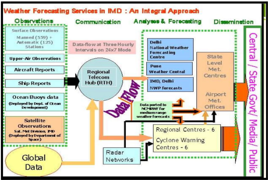
- Data Utilisation: India relies on satellite data and computer models for weather predictions. The Indian Meteorological Department (IMD) utilises the INSAT series of satellites and supercomputers such as Mihir and Prathyush to analyse weather patterns.
- Data Source: The IMD employs various sources for data, including manned and automatic weather stations, aircraft, ships, weather balloons, ocean buoys, and satellites.
-
- IMD is also increasingly using Doppler radars to improve efficiency in predictions.
- Doppler radar is a specialised radar that uses the Doppler effect to produce velocity data about objects at a distance.
- They are used to predict rainfall in the immediate vicinity, making predictions more timely and accurate.
- The number of Doppler radars has increased from 15 in 2013 to 37 in 2023.
Indian Institute of Tropical Meteorology (IITM)
- Location: Pune, Maharashtra, India
- Purpose: To expand research on the Ocean-Atmosphere Climate System for improving weather and climate forecasts.
- Role: Functions as a national centre for basic and applied research in monsoon meteorology.
- Governance: Autonomous institute under the Ministry of Earth Sciences, Government of India.
|
- Key Variables: Forecasters examine factors such as cloud motion, cloud top temperature, and water vapour content to estimate rainfall and track cyclones.
- Forecasting Process: The Indian Institute of Tropical Meteorology issues the first long-range monsoon forecast in April every year, updating it at the end of May and revising it monthly.
Check Out UPSC CSE Books From PW Store
Significance of Accurate Weather Predictions
- Preparedness Benefits: High-accuracy weather predictions are vital for better preparation against extreme weather events, facilitating timely warnings, coordinating power supplies, and advising farmers on crop protection.
- Public Safety: Clear and accurate predictions enhance public safety by providing timely warnings about severe weather, allowing individuals and organisations to take necessary precautions.
- Example: Lightning strikes are the number one cause of nature-propelled deaths in India and were responsible for 2,821 accidental deaths attributable to natural forces in 2022, according to the latest NCRB report.
- Resource Management: Accurate predictions help in effective resource allocation, such as deploying emergency services and distributing relief materials during disasters.
- Example: Accurate predictions during Cyclone Amphan in 2020 enabled the evacuation of over a million people and effective resource allocation in West Bengal and Odisha.
Challenges Related to Weather Forecasting In India
- Inadequate Weather Monitoring Ground Stations: There are a total requirement of more than 3,00,000 ground stations (AWS/ARG) and around 70 DWRs.
- However, currently, IMD operates around 800 automatic weather stations (AWS), 1,500 automatic rain gauges (ARG) and 37 doppler weather radars (DWR).
- This results in data collection gaps especially in rural and remote areas which hinder real-time data collection, causing forecasts to rely on outdated historical rainfall patterns.
- Technological Constraints: India faces limited resources for advanced forecasting technology due to budget constraints.
- Example: Only five radars monitor the entire west coast of India.
- Ahmedabad (Gujarat), Bengaluru (Karnataka), and Jodhpur (Rajasthan), which have faced repeated flooding recently, do not have radars as yet.
- Climate Change: Extreme weather events, influenced by climate change, have become more frequent and unpredictable, making the annual monsoon more challenging to forecast, significant disasters (e.g., landslides in Kerala, lake outbursts in Sikkim and Uttarakhand).
- Accuracy Issues: IMD’s forecasts have improved over the past decade but still struggles with local accuracy.
- Example: Inaccurate rainfall predictions for Mumbai on about 40% of days in July, 2024 as per the report of Indian Express.
- Ineffective Coordination with Local Authorities: Hinders timely responses to weather warnings.
- Example: In October 2023, heavy rainfall and floods in Uttarakhand showed poor coordination, as local authorities delayed responding to IMD’s early warnings.
- Varied Climate Zones: India’s diverse geography means that weather patterns can differ significantly across regions, complicating the forecasting process.
- The presence of mountains, plains, and coastlines can lead to localised weather phenomena that are difficult to predict
Initiatives Related to Weather Forecasting in India
- Mission Mausam: It was approved in September 2024 with a ₹2,000 crore budget.
- Nodal Body: The Ministry of Earth Sciences.
- Implementing Institutes: It is Implemented by the India Meteorological Department (IMD), the National Centre for Medium Range Weather Forecasting (NCMRWF), and the Indian Institute of Tropical Meteorology (IITM).
- Aim: The mission focuses on expanding the observation network with advanced instruments and enhancing forecasting accuracy through improved atmospheric physics and machine learning.
- It targets high climate risk areas and ensures data accessibility for sectors like energy, agriculture, and water management, enabling a transition to hyperlocal extreme weather forecasting for better preparedness and response.
- National Monsoon Mission: Initiated by the Ministry of Earth Sciences in 2012 to transition from historical pattern reliance to real-time data collection.
- Under the Monsoon Mission, the Ministry has developed state-of-the-art weather and climate prediction models.
- Example: Models for short range to medium range (1-10 days), extended range (10 days to 30 days) and seasonal (up to one season).
- Mausam App: IMD launched an integrated GIS based interactive mobile app MAUSAM for all weather-related services like current weather, Rainfall, Humidity, Sunrise/Sunset, Moonrise/Moonset etc.
- The app supports 12 Indian languages for varied users in India.
- Mausamgram: It is an IMD tool that gives real-time weather updates and forecasts for specific locations.
- Available on the “Mausam” app and website, it provides hourly and 3-6 hourly forecasts for up to 10 days using place names or pincodes.
- WAFES: WAFES (Weather Analysis and Forecast Enabling System) is an in-house Web-GIS-based decision support system developed by IMD inspired by Pancha Mahabhuta i.e. Water, Air, Fire, Earth and Sky.
- It provides real-time information for various sectors such as Urban, Power, Hydrology, Health, Energy, Agriculture, Transport and Tourism under the “UPHHEATT” initiative (for the cause of welfare).
- Panchayat Mausam Sewa for Farmers: The Panchayat Mausam Sewa Portal, developed by IMD, Ministry of Earth Sciences, Ministry of Panchayati Raj, and Green Alert Mausam Sewa.
- It provides weather forecasts in English, Hindi, and 12 regional languages to panchayat heads and secretaries, ensuring weather updates reach every village in India.
- National Framework of Climate Services (NFCS): The NFCS, introduced by IMD, offers climatology data on key weather parameters and extremes, updated every 10 years.
- IMD has digitised data since 1901 and provides public access to climate visualisations and vulnerability maps.
- Since 2021, monthly and seasonal climate forecasts have been available.
Enroll now for UPSC Online Classes
Way Forward For Enhancing Weather Forecasting In India
- Enhanced Data Collection
- Denser Instrument Networks: Install a greater number of weather monitoring instruments (e.g., rain gauges, temperature sensors) across localised areas to gather more granular data.
- Mobile Weather Stations: Deploy mobile weather stations in critical areas to provide real-time data during extreme weather events.
- Private Cooperation: Example: States such as Kerala, Odisha and Maharashtra have sought the help of private agencies to augment IMD’s information.
- Technological Additions: Example: India is set to acquire its fastest supercomputer by next year for ₹900 crore, three times faster than existing systems, improving block-level weather forecasts.
- Prioritise installing weather observation platforms on India’s western coast and in large urban centres facing high climate risks.
- The government intends to add 25 more Doppler radars in the next two to three years.
- Integration of Technology: Greater use of artificial intelligence (AI) and machine learning (ML) for hyperlocal rainfall forecasts through pattern recognition and anomaly detection.
- Example: Experimental models from IIT-Bombay have shown promising results, achieving higher accuracy than IMD.
- Utilise Communication Strategies: There is a need to create tailored weather information for local communities and disseminate the same using various channels such as mobile apps, social media, community radio etc to effectively reach a wider audience.
- Engage local communities in weather observation: Example: India’s Citizen Weather Observer Program encourages local residents to act as weather observers by reporting daily weather conditions through a mobile app.
- Open Access to Weather Data: Make weather data openly available for researchers and entrepreneurs to develop use cases for better understanding of the causes behind extreme weather events.
- It also helps in the creation of localised early warning tools.
- Example: United States, United Kingdom, France, and the European Union have made their weather forecasting data available on cloud for anyone to access.
- Public Feedback Mechanism: Create channels for the public and local authorities to provide feedback on forecast accuracy, allowing for continuous refinement of prediction models.
Conclusion
Accurate weather predictions are crucial for India, one of the nations most vulnerable to climate change. They enable better preparedness through early warnings for heat and rainfall, coordination of power supplies, and guidance for farmers to safeguard their crops.
![]() 21 Oct 2024
21 Oct 2024

