The Indian Union Defence Minister warned Pakistan over the Sir Creek region, reiterating India’s firm stance on its territorial integrity. His remarks come amid heightened tensions following the Pahalgam attacks and Operation Sindoor.
Sir Creek- Geography, Strategic Importance, and Significance
- Sir Creek, originally called ‘Ban Ganga’ and later renamed after a British official, is a 96-km tidal estuary along the India-Pakistan border, lying between Gujarat in India and Sindh in Pakistan, and flowing into the Arabian Sea.
- Maritime and Sovereignty Importance: Control over Sir Creek determines the maritime boundary between India and Pakistan, influencing the extent of their Exclusive Economic Zones (EEZs), which extend up to 200 nautical miles, granting rights over marine resources, both living and non-living.
- Energy and Economic Interests: The region is believed to harbor oil and gas reserves, making it crucial for energy exploration and economic activities. Its location also provides access to key maritime routes, including the approach to Karachi.
- Security and Defence: Pakistan’s increased military presence has led India to reinforce surveillance and deploy the BSF and Navy, highlighting its geo-strategic importance.
- Fisheries and Livelihoods: Rich fishing grounds sustain local communities, though boundary disputes often result in arrests of fishermen.
- Ecological Significance: Part of the Indus Delta ecosystem, Sir Creek supports mangroves and biodiversity, but faces challenges from Pakistan’s LBOD project and climate change, affecting both ecology and boundary stability.
Background of the Dispute
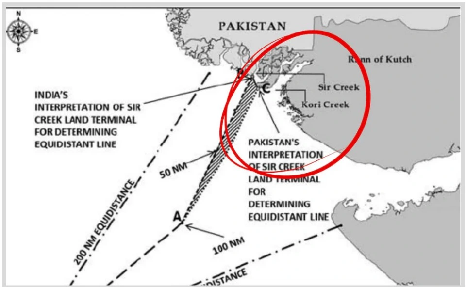
- Core of Dispute: The Sir Creek dispute stems from the varying interpretations of colonial-era boundary lines by both the nations.
- The matter is compounded by the changing course of the Indus over the years.
- Origin: The dispute dates back to 1914, revolving around the boundary between the Bombay Presidency and the Kutch Princely State.
- UN Tribunal: The Rann of Kutch dispute resurfaced post-Independence and intensified after the 1965 Indo-Pak war.
- Under the 1965 Agreement for the Determination of the Border, the issue was referred to a UN Tribunal.
- The 1968 Tribunal Award recognized 90% of India’s claims, conceding only small sectors to Pakistan — but excluded Sir Creek from its jurisdiction.
- Competing Claims:
- India’s Position:
- Relies on Survey of India maps and the 1819 Treaty between the East India Company and the Rulers of Kutch.
- Argues that Sir Creek is land, not a water boundary, hence no need for a median line division.
- Asserts that Kutch’s boundaries remained unchanged and that the northern edge of the Rann marks the natural border.
- Pakistan’s Position:
- Cites the 1914 Resolution, arguing for the median line principle — equal division of the creek.
- Contends that the Rann of Kutch is akin to an inland sea, and boundaries should follow international norms for water bodies.
- Places the border roughly along the 24th parallel, involving about 3,500 square miles of territory.
Attempts at Resolution
- Joint Efforts: India and Pakistan conducted joint hydrographic surveys in 2007.
- Both countries exchanged relevant data to assess the creek and maritime boundaries.
- Current Status: Despite these efforts, the Sir Creek dispute remains unresolved.
- Legal Constraints: The Simla Agreement (1972) prohibits third-party mediation in bilateral disputes.
- Referring the matter to the International Court of Justice (ICJ) would require mutual consent, which is currently unlikely.
Way Forward
- Bilateral Dialogue: Peaceful resolution through sustained dialogue under existing frameworks.
- Confidence-Building Measures (CBMs): Joint ecological monitoring, fisherman welfare cooperation, and hydrographic updates.
- Strategic Prudence: Maintaining vigilance while promoting diplomacy aligns with India’s vision of regional stability and maritime security.
Conclusion
Sir Creek epitomizes how colonial-era ambiguities continue to influence post-colonial geopolitics. A mutually agreed settlement, balancing strategic, economic, and ecological concerns, remains the only viable path forward.


 6 Oct 2025


.png)


 Current Affairs


 GS Foundation
 Optional Course
 Combo Courses
 Degree Program