GS III: Conservation, Environmental Pollution and Degradation
Context: The Union Government is attempting to finalize the Ecologically Sensitive Area (ESA) notification for the Western Ghats, based largely on recommendations of the K Kasturirangan Committee (2013).
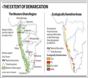
About the Western Ghats
- The Western Ghats are about 1,500–1,600 km long, running parallel to India’s western coast across Gujarat, Maharashtra, Goa, Karnataka, Kerala and Tamil Nadu.
- They are recognised as a UNESCO World Heritage property and one of the world’s eight hottest biodiversity hotspots.
- The Agasthyamala Biosphere Reserve is located in the southern Western Ghats.
- The latest ESA process is based mainly on the Kasturirangan Committee framework, with the 2024 sixth draft notification proposing around 56,825.7 sq km as ESA across six states.
- Major Rivers Originating in the Western Ghats:
- Godavari
- Krishna
- Cauvery
- Periyar
UPSC Course Fees Online
What is an Ecologically Sensitive Area (ESA)?
- An Ecologically Sensitive Area (ESA) is a region notified under the Environment (Protection) Act, 1986, where environmentally harmful activities are regulated or prohibited to protect fragile ecosystems.
- Objectives:
-
- Conserve biodiversity and ecological integrity.
- Prevent environmental degradation.
- Promote sustainable development.
- Regulate polluting and high-impact activities.
Recommendations of Various Committees
- Madhav Gadgil Committee (2011):
- Entire Western Ghats as ESA: Recommended notifying the entire Western Ghats as an ESA.
- Ecological Zoning: Proposed ESZ-I, ESZ-II, and ESZ-III based on ecological sensitivity.
- Strict Protection: Recommended banning mining, quarrying, thermal power plants, and large dams in highly sensitive areas.
- K. Kasturirangan Committee (2013):
- Landscape Approach: Classified the Ghats into Natural and Cultural Landscapes.
- Reduced ESA: Recommended notifying only about 60,000 sq km as ESA.
- Balanced Framework: Prohibited high-impact activities while permitting sustainable development in inhabited areas.
- MoEFCC Draft Notification (2014):
- Refined ESA Boundary: Proposed 56,825.7 sq km across six states as ESA.
- Regulated Activities: Prohibited new mining, quarrying, thermal power plants, and red-category industries.
- Sanjay Kumar Committee (2022–2026):
- Mapping Disputes: Examined village-level mapping issues and state objections.
- Flexible Implementation: Recommended state-wise phased implementation of ESA notifications.
Why Do the Western Ghats Need Protection?
- Biodiversity Hotspot: The Western Ghats harbour exceptional biodiversity with a high level of endemic flora and fauna.
- Water Security: The Ghats sustain major peninsular rivers and recharge groundwater, supporting millions of people.
- Climate Regulation: Dense forests sequester carbon, regulate temperatures, and influence monsoon rainfall.
- Disaster Mitigation: Healthy ecosystems reduce the risks of landslides, floods, and soil erosion.
- Livelihood Support: The region provides vital ecosystem services that sustain millions of livelihoods.
Major Concerns of States
- Livelihood Impact: States fear ESA restrictions could adversely affect agriculture, plantations, and rural livelihoods.
- Development Constraints: Restrictions on infrastructure projects may slow regional development.
- Industrial Growth: Limitations on industries could discourage investment and economic expansion.
- Mining Restrictions: Curbs on mining and quarrying may reduce employment and state revenues.
- Settlement Concerns: Local communities fear land-use restrictions and possible livelihood losses.
- Boundary Disputes: States have raised concerns over inaccuracies in ESA mapping and village demarcation.
- Federal Concerns: States seek greater participation in ESA implementation.
Why Does Consensus Remain Difficult?
- Conservation–Development Dilemma: Balancing ecological protection with economic development remains challenging.
- Centre–State Differences: The Centre and states continue to differ on ESA boundaries and permissible activities.
- Livelihood Concerns: Communities fear that ESA regulations could restrict economic opportunities.
- Boundary Ambiguity: Disputes over satellite-based mapping have delayed ESA finalisation.
- Limited Incentives: States seek greater financial support to offset conservation-related costs.
Way Forward
- Scientific ESA Mapping: ESA boundaries should be based on transparent, scientifically validated, and ground-verified mapping.
- Community Participation: Local communities should be active partners in conservation and decision-making.
- Payment for Ecosystem Services: States and communities should receive financial incentives for conserving ecosystem services.
- Sustainable Livelihoods: Conservation should promote sustainable agriculture, eco-tourism, and agroforestry.
- Regulated Mining: Mining and quarrying should be strictly monitored and environmentally regulated.
- Cooperative Federalism: The Centre and states should adopt a consultative approach to ESA implementation.
- Landscape-Based Planning: Conservation and development should be integrated through landscape-level planning.
- Climate-Resilient Development: Regional planning should incorporate climate resilience and disaster-risk reduction.
Click to Know UPSC Offline Courses
Conclusion
Protecting the Western Ghats is indispensable for ensuring India’s biodiversity conservation, water security, climate resilience, and sustainable development.
 26 Jun 2026