Books

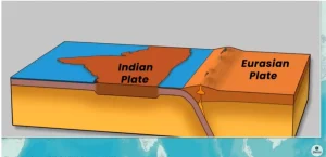
The Himalayas formed due to the collision of the Indian and Eurasian plates, leading to the folding of the Tethys Sea sediments. Their formation occurred in phases, creating major ranges like the Greater Himalayas and the Shivaliks, making them crucial for India’s climate, water, and security.

The Himalayas are not just the tallest mountain range in the world—they are a result of millions of years of geological transformation. Many students wonder how to form the Himalaya Mountain and what forces shaped such massive structures. The answer lies deep within Earth’s tectonic movements, where continents collided and oceans disappeared.
Understanding their formation is important not only for geography exams but also to grasp climate patterns, natural resources, and environmental challenges in India.
It is a geological fact that approximately 500 million years ago, a vast ocean, known as the Tethys Sea, existed where the Himalayas stand today. This discussion will focus on understanding the complex geological origin of the Himalayas, which possesses a history far more extensive than its physical size.
The geographical location of the Himalayas is profoundly significant for India.
A recent report indicates that due to accelerating climate change, 75% of Himalayan glaciers may melt within the next few decades, potentially leading to disastrous floods in the surrounding regions. Understanding the Himalayas and their origin is essential to comprehend the significant impact of climate change in this region.
Before delving into the complex geological history of the Himalayas, it is important to understand how mountains form. Mountains are categorized into various types:
This discussion will primarily focus on Fold Mountains.
A fold mountain forms when two or more continental tectonic plates push against each other. This creates immense geological pressure within the tectonic plates, causing the Earth’s surface to fold and rise into mountains. In geological terms, this process is known as orogeny.
The Himalayan Mountains are among the world’s tallest mountain ranges. They extend from the Pamir Knot in the west to the Purvanchal Mountains in the east. The Himalayas are not a single mountain but a group of several mountain ranges, including:
The Trans Himalayas can be further subdivided into the Karakoram, Ladakh, Kailash, and Zanskar ranges.
Geologists suggest that the Himalayas did not form in a single event but underwent a prolonged formation and development period, which can be divided into different phases.
The formation of the Himalayas resulted from the collision of the Indian Plate with the Eurasian Plate.
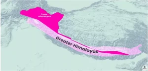
The first phase of Himalayan formation involved the creation of the Trans Himalayas and the Greater Himalayas. As previously mentioned, their formation resulted from the rising of the Tethys Sea floor, indicating a significant contribution of the original Tethys Sea floor sediments.
The black color of the sediments found in the Karakoram ranges is attributed to the living creatures present in the Tethys Sea. Under extreme pressure and sedimentation, these creatures transformed into black fossils, making most of the mountains in the Trans Himalayas appear black. The Trans Himalayan range also contains vast reserves of glaciers.
K2 (Godwin Austen), the world’s second-highest peak and India’s highest peak, is located in the Trans Himalayas. These mountain ranges have an average height of 3,000 meters and an average width of 40 kilometers. Most of the Trans Himalayas lie in the Tibet Region, extending into India primarily across the Jammu and Kashmir and Ladakh regions.
| Formation of Trans Himalayas and Greater Himalayas | ||
|---|---|---|
| Feature | Trans Himalayas | Greater Himalayas |
| Formation Phase | First Phase of Himalayan formation | First Phase of Himalayan formation |
| Sediment Origin | Primarily Tethys Sea sediments (fossils) | Primarily Tethys Sea sediments |
| Notable Peaks | K2 (Godwin Austen) | Mount Everest (world’s highest), Kanchenjunga (India’s 2nd highest), Dhaulagiri, Nanga Parbat, Annapurna |
| Average Height | 3,000 meters | 6,100 meters |
| Average Width | 40 kilometers | 25 kilometers (approximately) |
| Location in India | Jammu and Kashmir, Ladakh | Jammu and Kashmir to Sikkim |
| Passes | – | Zoji La, Burzil La, Shipki La, Nathu La |
| Structure | Part of an arc from Nanga Parbat (west) to Namcha Barwa Peak (east). | Mount Everest is the world’s highest peak. K2 (Godwin Austen) is India’s highest (and the world’s second highest), while Kanchenjunga is India’s second highest peak. |
| Other | Trans-Himalayan region in Tibet has black sediments due to black fossils of marine life in Tethys Sea. | The Kathmandu Valley is situated between the Trans Himalayas and the Middle Himalayas. |
Following the rise of the Trans Himalayas and Greater Himalayas, the Lesser Himalayas (also known as the Middle Himalayas) were formed. The Indian Plate and the Eurasian Plate continued to collide even after the initial formation of the Trans Himalayas. This continuous collision caused sediments deposited along the Main Boundary Fault to fold and rise as mountain ranges, which are known as the Lesser Himalayas.
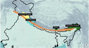
Important ranges within the Lesser or Middle Himalayas include Pir Panjal, Dhauladhar, Mussoorie Range, Nag Tibba, and Mahabharat Ranges. Many popular hill stations like Shimla, Mussoorie, Ranikhet, Nainital, Almora, and Darjeeling are located in the Lesser Himalayas. Mountains of the Lesser Himalayas are found in Himachal Pradesh, Uttarakhand, Sikkim, and Arunachal Pradesh.
The Shivalik Ranges (also known as the Outer Himalayas) were formed approximately 2 to 20 million years ago. These ranges are situated between the Lesser Himalayas and the Great Plains. They extend discontinuously for about 2400 kilometers from Himachal Pradesh to Arunachal Pradesh.
The Shivalik Range was formed from sand, gravel, and alluvial deposits brought by rivers flowing through the region. Due to compression, these deposits gradually hardened over time, leading to the formation of the Shivalik Range.
Most mountains in the Shivalik Range are composed of sedimentary rocks such as sandstone, sandrock, clay, conglomerate, and limestone. Their average height ranges from 600 meters to 1500 meters. Their average width is 50 kilometers in Himachal Pradesh but narrows to just 15 kilometers in Arunachal Pradesh.
| Region | Local Name for Shivalik Mountains |
|---|---|
| Jammu Region | Jammu Hills |
| Arunachal Pradesh | Daphla, Abor, Mishmi Hills |
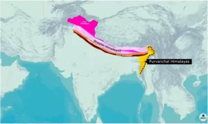
The Purvanchal Himalayas represent the final range of the Himalayas, located parallel to the India-Myanmar border from Arunachal Pradesh to Mizoram. Their rise is attributed to the southern (southward) bending of the Himalayan ranges, also known as Himalayan syntaxial bends.
Parts of the Mishmi Hills, Patkai-Bum, Naga Hills, and Lushai Hills of Mizoram are components of the Purvanchal Himalayas. These hills are generally lower in height compared to the Western Himalayas. The Purvanchal Himalayas are located in four Northeastern states of India: Arunachal Pradesh, Nagaland, Manipur, and Mizoram.
Check Out UPSC CSE Books
Visit PW Store
Explore UPSC Test Series

Approximately 500 million years ago, the Tethys Sea covered the area where the Himalayas now stand. The folding and rising of its sediments, caused by the collision of the Indian and Eurasian Plates, directly led to the Himalayan ranges' formation.
Fold Mountains form when two or more continental tectonic plates push against each other. This immense pressure causes the Earth's surface to fold and rise, a process known geologically as orogeny.
The Himalayas formed due to the collision of the Indian Plate with the Eurasian Plate. The Indian Plate subducted beneath the Eurasian Plate, initiating the mountain-building process.
The Himalayan system comprises several ranges, including the Trans Himalayas, Greater Himalayas, Lesser Himalayas (Middle Himalayas), Outer Himalayas (Shivaliks), and Purvanchal Himalayas.
The black color in parts of the Trans Himalayas is due to black fossils of marine creatures from the ancient Tethys Sea. Under extreme pressure and sedimentation, these organisms transformed, contributing to the dark appearance of the sediments.


Explore SRIJAN Prelims Crash Course

Connect with our experts to get free counselling & start preparing
Books
Udaan (Prelims Wallah)
Prahaar (Mains Wallah)
Q&A Bank (Prelims & Mains)
Budget & Economic Survey
NCERT Wallah
Marks Booster
हिंदी माध्यम विशेष शृंखला
 Current Affairs
Monthly Current Wallah
Subject Wise Current Affairs
Editorial Analysis
Editorial PDFs
News of The Day
Download Our App


Download Our App
<div class="new-fform">
</div>


 GS Foundation
 Optional Course
 Combo Courses
 Degree Program