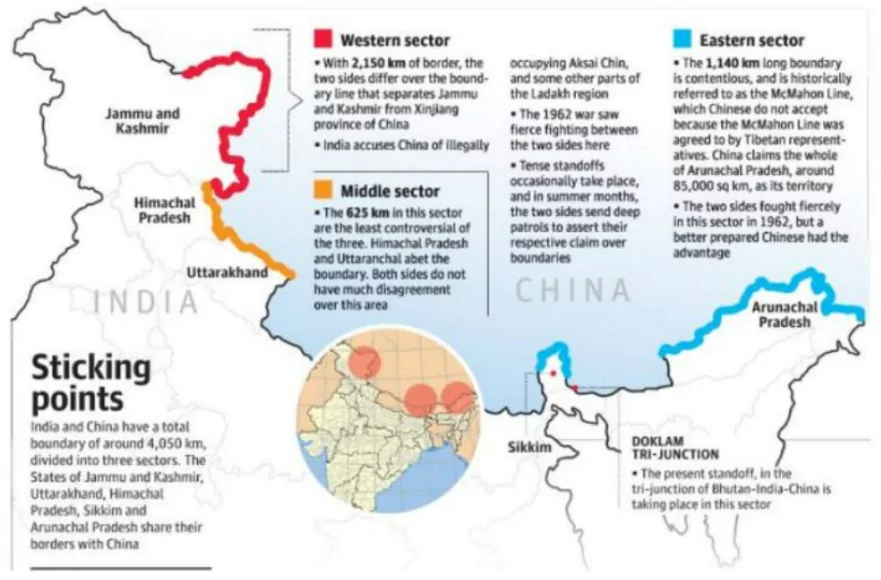
The Line of Actual Control (LAC) is the demarcation line between India and China, divided into three sectors. The Line of Actual Control stretches approximately 3,488 kilometers.

The Line of Actual Control (LAC) is the de facto boundary between India and China, marking the line of control in areas where the two countries have territorial disputes. It is not an officially recognized international boundary, but rather a military control line that separates areas controlled by India from those controlled by China.
With periodic clashes and an unsettled boundary agreement, the LAC has become central to India-China relations and is a significant topic for UPSC exams. Keep reading to learn about the Line of Actual Control, its length, and the disputes surrounding it.
The Line of Actual Control (LAC) is the unofficial boundary that separates Indian-administered areas from Chinese-controlled areas. Although it is not an officially agreed-upon border, the LAC serves as a de facto dividing line to help prevent conflict. However, its lack of clear demarcation has led to frequent tensions between the two countries.
Since the LAC is not legally defined, India and China often have different interpretations of its exact alignment. India considers the LAC to be approximately 3,488 kilometers long, while China claims it to be only around 2,000 kilometers. The LAC spans three sectors: the western sector, the middle sector, and the eastern sector.
British India and China had overlapping territorial claims in the regions that now constitute the border areas of Ladakh, Himachal Pradesh, Uttarakhand, Sikkim, and Arunachal Pradesh. After India gained independence in 1947, tensions between India and China regarding the border quickly emerged.
After the war, both India and China agreed to maintain the status quo along the border, and LAC came to be understood as the line that both countries effectively controlled at the time, though its exact alignment was undefined.

The India-China border is approximately 3,488 kilometers long, divided into three major sectors:
The state-wise length of the Indo-China border is as follows:
| State | Total Length (km) |
| 1. Jammu & Kashmir | 1,597 |
| 2. Himachal Pradesh | 200 |
| 3. Uttarakhand | 345 |
| 4. Sikkim | 220 |
| 5. Arunachal Pradesh | 1,126 |
| Total | 3,488 |
The India-China border dispute across LAC remained a point of tension which have affected the Indo-China relationship over the years. These disputes include:
To resolve these disputes, India and China have engaged in multiple rounds of talks, including border negotiations and confidence-building measures including:
Though the terms are often confused the Line of Actual Control is different from the McMahon Line:
The Line of Actual Control and the Line of Control (LoC) are two significant border demarcations. While LAC separated India from China, LoC emerged from the 1948 ceasefire line with Pakistan.
| LAC vs LoC | ||
| Aspect | Line of Actual Control (LAC) | Line of Control (LoC) |
| Countries Involved | India and China | India and Pakistan |
| Historical Context | Emerged after the 1962 India-China war but with no final settlement. | Emerged after the 1947-48 Kashmir conflict and was formalized in the 1972 |
| Legal Recognition | Not legally recognized; based on mutual understanding, no formal agreement. | Legally recognized; established by the 1972 Shimla Agreement and the 1948 UN ceasefire line. |
| Geographical Location | Spans through Eastern, middle, and Western sectors | Divides Jammu and Kashmir into Indian- and Pakistan-administered areas |
| Conflict History | Frequent stand-offs, no mutual agreement | Heavily militarized with frequent conflicts and skirmishes |
Ready to boost your UPSC 2025 preparation? Join PW’s UPSC online courses today!
UPSC Exam 2025 Related Articles
UPSC Prelims 2025 Exam
UPSC Notification 2025
UPSC Preparation 2025
UPSC Eligibility 2025
UPSC Exam Pattern
UPSC Syllabus
The Line of Actual Control is the informal boundary that separates Indian-administered and Chinese-controlled areas.
The LAC is disputed because India and China interpret its path differently, leading to overlapping territorial claims and periodic stand-offs.
The length of the line of actual control is approximately 3,488 kilometers, though the exact figure varies due to differing interpretations.
The LAC is the current, disputed boundary, while the McMahon Line was drawn in 1914 as an official boundary between British India and Tibet in the eastern sector.
The LAC is a disputed boundary between India and China, while the LoC is a recognized line between India and Pakistan, established after the Simla Agreement in 1972.
<div class="new-fform">
</div>