Udaan, Prahaar, Q&A Bank etc.
CA Magazines & Editorials
National Highways in India 2026 – State-wise NH list, length & map details. India has 599 National Highways covering 1,46,145 km with renumbered routes & updates.
National Highways in India 2026: National Highways play a crucial role in connecting different regions and fostering economic growth and development throughout the country. As transportation networks continue to evolve, several National Highways in India have been renumbered or renamed to streamline navigation and improve connectivity. With around 599 national highways, India’s National Highways have covered a total length of around 1,46,145 km, enhancing the transportation of goods and movement of people across the country.
Explore UPSC Foundation Courses

Explore UPSC Foundation Courses

This table presents a snapshot of these changes, shedding light on the new designations assigned to these vital roadways. Additionally, the table includes information on the total length of National Highways in India in each state, underscoring their significance in shaping India’s vast road infrastructure. Explore the table to gain insights into the National Highway in India network and its evolution in various regions of the country.
| List of National Highways in India 2026 | ||
|---|---|---|
| States/UTs | Old National Highway Number | New National Highway Number |
| Jammu & Kashmir | NH 1 A and NH 1 D | NH 1 B NH 244 |
| Bihar, Delhi, Haryana, Jharkhand, UP, WB | NH 2 | NH 19 (Golden Quadrilateral) |
| Uttar Pradesh | NH 2A | NH 519 |
| West Bengal | NH 2B | NH 114 |
| Maharashtra | NH 3 | NH 50 |
| Andaman & Nicobar Islands | NH 223 | NH 4 |
| Goa, Karnataka | NH 4 A | NH 748 |
| Maharashtra | NH 4 B | NH 348 |
| AP, Odisha, TN, WB | NH 5 | NH 16 (Golden Quadrilateral) |
| Madhya Pradesh, UP NH 7 NH 135 |
||
| Tamil Nadu | NH 7 A | NH 138 |
| Delhi, Gujarat, Haryana, KA, MH, RJ, TN | NH 8 | NH 48 (Golden Quadrilateral) |
| Gujarat | NH 41
NH 147 |
NH 151 |
| AP, MH, KA, Telangana | NH 9 | NH 65 |
| Rajasthan, UP | NH 11 | NH 21 |
| Rajasthan | NH 11 A | NH 148 |
| MP, Chhattisgarh | NH 12 | NH 45 |
| AP, TN | NH 18
NH4 |
NH 40 |
| Haryana, Chandigarh, HP, Punjab | NH 21
NH 5 |
NH 22
NH 95 |
| West Bengal | NH 35 | NH 112 |
| Bihar | NH 30 | NH 319 |
| UP | NH 24 | NH 530 |
| Jharkhand | NH 23 | NH 320 |
| West Bengal | NH 55 | NH 110 |
| Kerala | NH 47 A
NH 47 C |
NH 966 B
NH 966 A |
| Kerala, TN | NH 47 | NH 544 |
| Assam, Nagaland | NH 39 | NH 129 |
| Assam, Arunachal Pradesh | NH 38 & NH 153 | NH 315 |
| Assam | NH 152 | NH 127 A |
| Rajasthan | NH 79 | NH 156 |
| UP | NH 56 | NH 731 |
India has a total of 599 national highways. They form the backbone of the country’s transportation system, serving as vital arteries that facilitate the movement of goods, people, and services across vast distances. With each state having its unique geographical features and developmental needs, the length of National Highways in India varies significantly, reflecting the diverse infrastructure requirements and connectivity challenges faced by each region.
The list below presents a valuable compilation of data, offering valuable insights into the extensive road network and its distribution across the various states and Union Territories. Check the data below to learn about the length of national highways in India.
| State-wise Length of National Highways in India | |
|---|---|
| States | Length (in km) |
| Andhra Pradesh | 6529.5 |
| Arunachal Pradesh | 2537.4 |
| Assam | 3908.5 |
| Bihar | 5030.6 |
| Chhattisgarh | 3605.8 |
| Goa | 292.9 |
| Gujarat | 6635 |
| Haryana | 3097.6 |
| Himachal Pradesh | 2606.9 |
| Jharkhand | 3366.8 |
| Karnataka | 7334.8 |
| Kerala | 1781.6 |
| Madhya Pradesh | 8772.3 |
| Maharashtra | 17756.6 |
| Manipur | 1750.3 |
| Meghalaya | 1155.6 |
| Mizoram | 1422.5 |
| Nagaland | 1547.7 |
| Odisha | 5761.5 |
| Punjab | 3769.5 |
| Rajasthan | 9988.8 |
| Sikkim | 463 |
| Tamil Nadu | 6741.5 |
| Telangana | 3795.5 |
| Tripura | 8 |
| Uttar Pradesh | 11736.8 |
| Uttarakhand | 2949.3 |
| West Bengal | 3664.5 |
National Highways in India form the backbone of the country’s road transportation network, connecting major cities, towns, and industrial centers across vast distances. Covering thousands of kilometers, these well-maintained roads ensure efficient movement of goods and people, bolstering India’s overall infrastructure and contributing to its development.
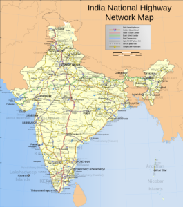
As key arteries of India’s road system, National Highways significantly contribute to the country’s social integration and are vital in reducing travel time, transportation costs, and fuel consumption. They are essential for the nation’s progress and reflect the government’s commitment to enhancing connectivity and accessibility for all citizens. Below is the National Highways in India on Map.
The details about how national highways in India are numbered are presented as bullet points:
As of 2026, India has a total of 599 National Highways, covering a length of approximately 1,46,145 kilometers. These highways form the backbone of the country’s road infrastructure, facilitating efficient transportation and connectivity across states and regions.
The numbering and details of these highways are periodically updated by the Ministry of Road Transport & Highways to reflect new developments and realignments.
Explore Prarambh Course

Explore Prarambh Course

Here are some interesting facts about national highways in India:
These facts highlight the diverse and impressive nature of India’s national highways, showcasing their historical significance, engineering marvels, and contributions to the country’s transportation infrastructure.
Ready to boost your UPSC 2026 preparation? Join PW’s UPSC online courses today!
Explore SRIJAN Courses

The longest National Highway in India is NH 44 (formerly NH 7), which stretches from Jammu and Kashmir to Kanyakumari. It traverses through 11 states, including Himachal Pradesh, Punjab, Haryana, Delhi, Uttar Pradesh, Madhya Pradesh, Maharashtra, Telangana, Andhra Pradesh, Karnataka, and Tamil Nadu.
The shortest National Highway in India is NH 966 B (formerly NH 47A), covering a mere 8 km distance between Kundanoor and Willingdon Island in Kochi, Kerala.
The Golden Quadrilateral is a remarkable National Highway network that connects India's four major metropolitan cities: Delhi, Kolkata, Mumbai, and Chennai. Highways forming the Golden Quadrilateral carry numbers ending in "5" and significantly improve connectivity between these major urban centers.
India boasts the second largest road network globally, constituting around 40% of the country's national highways. This extensive network plays a vital role in supporting India's transportation and economic development.
India had a total of 599 National Highways, covering a length of approximately 1,46,145 km.


Explore UPSC Foundation Batches

Connect with our experts to get free counselling & start preparing
Join India’s trusted platform for expert guidance, quality content, proven success.
Learn anytime, anywhere.


India's leading UPSC coaching platform helping aspirants prepare for IAS, IPS, IFS and other Civil Services examinations with the best faculty and proven strategies.
<div class="new-fform">
</div>