NCERT NOTES

Elevate your UPSC preparation with NCERT Notes – because every word matters on your journey to success.

Formation of Landform: Impact of Ice & Waves

December 2, 2023 1603 0

Introduction to Formation of Landform 

Landforms are the different shapes and features on the Earth’s surface, and they change over time because of things like water, wind and other natural forces, creating a constantly evolving landscape.

In this chapter, we will study different landforms and geographical agents which play a major role in Formation of these landforms. 
Formation of Landform: The Role of Glaciers in Shaping Earth’s Features

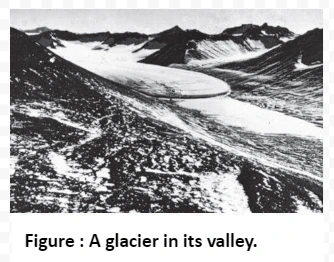
A glacier in its valley

  • Glaciers Formation:
    • Glaciers form from the accumulation, compaction, and recrystallization of snow over long periods of time. 
      • This occurs in regions where more snow accumulates in winter than melts in summer.
  • Types of Glaciers:
    • Continental Glaciers: These are large, continuous ice sheets that cover extensive areas of land, like those in Antarctica and Greenland.
    • Piedmont Glaciers: Formed by the spread of valley glaciers at the base of mountains onto adjacent plains.
    • Mountain Glaciers: Located in high mountain ranges, they flow down valleys from high-altitude regions.
      •  Found in valleys, often within mountainous regions, flowing down from high elevations.
  • Glacial Movement:
    • Glacial ice moves very slowly due to the force of gravity. 
    • This movement, known as glacial flow, can range from a few centimeters to a few meters per day.
  • Erosion by Glaciers:
    • Glaciers are powerful agents of erosion due to their immense weight and movement. 
    • They pluck and abrade the underlying bedrock, resulting in the removal of large angular blocks and Formation of glacial valleys.
  • Plucking and Abrasion:
    • Plucking: Occurs when glaciers freeze onto and detach rocks from the underlying bedrock as they move.
    • Abrasion: Involves the grinding and polishing of bedrock surfaces by the movement of debris within the ice.
  • Transformative Effects:
    • Glacial erosion can significantly alter landscapes. 
    • High mountains can be reduced to lower hills, and valleys can be widened and deepened.
  • Depositional Features:
    • As glaciers move, they transport and deposit sediment. 
    • This can result in Formation of Landform , including moraines (ridges of glacial debris), outwash plains, and kettle lakes.
  • Altering Topography:
  • Glaciers also have a leveling effect on the landscape. 
  • They remove material from higher elevations and deposit it in lower areas, gradually reducing slopes.

Formation of Landform: How Glaciers Carve Valleys and Peaks

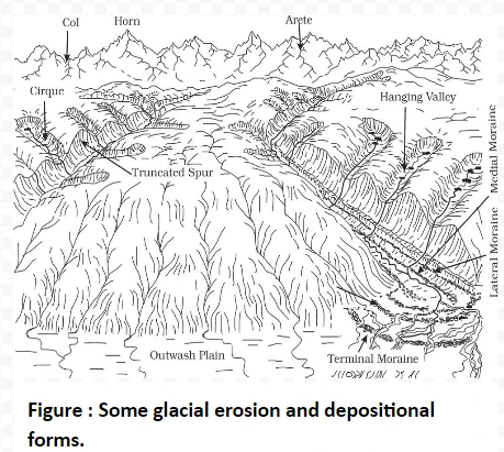
ome glacial erosion and depositional forms.

Cirque: 

  • Cirque are  deep, long, and wide troughs or basins typically located at the heads of glacial valleys.
    • Cirques often contain lakes known as cirque or tarn lakes.

Do you Know?

The highest peak in the Alps, Matterhorn and the highest peak in the Himalayas, Everest are in fact horns formed through headward erosion of radiating cirques.

Horns and Serrated Ridges: 

  • Horns: Horns are pointed peaks Form through headward erosion of cirque walls.
  • When multiple radiating glaciers cut headward until their cirques meet, sharp, pointed peaks called horns develop. 
  • Arêtes: Further, the divides between cirque side walls or head walls narrow due to progressive erosion, which form serrated or saw-toothed ridges called arêtes.

Glacial Valleys/Troughs: 

  • Glaciated valleys are U-shaped valleys with broad floors and relatively smooth, steep sides. 
    • These valleys may contain debris or moraines, and sometimes, lakes. 
  • Hanging valleys can also be found at higher elevations on the sides of the main glacial valley.
  • Fiords: In high latitudes, deep glacial troughs filled with seawater create fjords or fiords.

Formation of Landform Foundations: Glacial Deposits and Shaping the Landscape

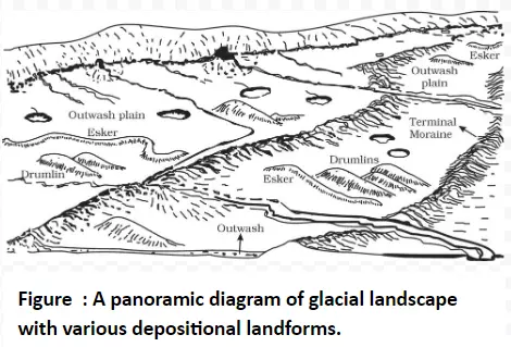
A panoramic diagram of glacial landscape with various depositional landforms.

Glacial Till: 

  • Glacial till is unsorted coarse and fine debris left behind as glaciers melt. 
  • It mainly consists of angular to sub-angular rocks.

Outwash Deposits: 

  • These are glacio-fluvial deposits formed by meltwater streams, characterized by stratification and assortment of materials. 
  • Rock fragments in outwash deposits have somewhat rounded edges.

Moraines: 

  • Moraines are long ridges of glacial till deposits
  • They are named differently on the basis of locations they found.
    • Terminal moraines are found at the end (toe) of glaciers, while lateral moraines form along the sides parallel to glacial valleys. 
    • These moraines may join to create horse-shoe-shaped ridges.
    • Valley glaciers retreating rapidly, often leave irregular sheets of till called ground moraines on their valley floors.
    • Medial moraines are found in the center of glacial valleys, flanked by lateral moraines, although they are less well-defined and may resemble ground moraines.

Eskers: 

  • These are sinuous ridges formed by water flowing beneath melting glaciers. 
  • When glaciers melt, water gathers beneath them and carries coarse materials. 
  • As the glacier vanishes, these materials form ridges called eskers. 

Outwash Plains: 

  • The plains at the foot of the glacial mountains are covered with glacio-fluvial deposits in the form of broad flat alluvial fans which join to form outwash plains of gravel, silt, sand and clay.

Drumlins: 

  • These are smooth, oval-shaped hills made of rocks and dirt. 
  • These hills have two ends. 
    • One end, called the stoss end, is flatter and steeper, while the other end is called the tail. 
  • Drumlins can tell us which way the glaciers were moving because they point in the same direction as the ice flow.

Formation of Coastal Wonders: Waves, Currents, and the Creation of Shorelines

  • Wave Action: Waves play a central role in shaping coastlines, causing erosion and deposition. 
  • Wave Breaking: Waves break with force on coastlines, leading to shoreline changes. 
    • Further, storm and tsunami waves can have significant impacts.
  • Along with action of caves, coastal landforms also depend on land and seafloor configuration and nature of the coast i.e. whether the coast is advancing(emerging) or retreating(submerging).
  • Two types of coasts are mainly seen: 
    • High Rocky Coasts where erosional features dominate and; 
    • Low Sedimentary Coasts where mainly deposition can be seen. 

Do You Know?

The west coast of our country is a high rocky retreating coast, dominated by erosional forms, while the east coast of India is a low sedimentary coast, where depositional forms prevail.
High Rocky Coasts:

  • Irregular Coastlines: In this, the rivers appear to have been drowned with highly irregular coastline. 
  • Cliffs: Waves break forcefully against rocky coasts, forming cliffs. 
  • Wave-Cut Platforms: Constant wave impact causes cliffs to recede, creating wave-cut platforms where eroded material is deposited.
  • Wave-Built Terraces: Over time, wave-built terraces develop in front of wave-cut terraces. 
  • Longshore Currents: Eroded materials supply longshore currents, forming beaches and submerged bars
  • Barrier Bars and Spits: Barrier bars and spits can block bays, forming lagoons that may fill over time, creating coastal plains.

Low Sedimentary Coasts:

  • Smooth Appearance: At these coasts, rivers extend their length by building coastal plains and deltas. 
  • Lagoons and Tidal Creeks: These coasts have a smooth appearance with lagoons and tidal creeks
  • Marshes and Swamps: The land gently slopes into the water, and marshes and swamps may be present.
  • Waves breaking over such coasts churn and move bottom sediments.
    • This process builds bars, barrier bars, spits, and lagoons. 
  • Lagoons can transition into swamps and eventually coastal plains.
  • Large rivers that carry sediments contribute to the Formation of deltas along these coasts.

Coastal Landscape: How Waves Build Cliffs, Caves, and Seascapes

  • Wave cut cliffs: They are steep and tall rock formations along the shore, reaching heights of up to 30 meters, forming coastal cliffs.
  • Wave cut terraces: Flat platforms made of rock debris at the base of cliffs, elevated above the average wave height.
    • Wave-cut cliffs and terraces are major landforms where erosion is the dominant process.
  • Caves: Hollows Formation of Landform by the impact of waves and rock debris against cliffs. 
    • Roofs of these caves collapse giving way for stacks.
  • Sea Stacks: Resilient rock masses, originally part of cliffs or hills, standing alone just off the shore. 
  • They are temporary and will eventually erode into narrow coastal plains.

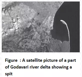
A satellite picture of a part of Godavari river delta showing a spit

Coastal Beauty: The Creation of Beaches, Dunes, and Barrier Bars

Beaches

  • Shoreline areas primarily Formation of Landform by deposition
    • Sediments on beaches are often sourced from land carried by rivers or waves. 
  • Beaches are not permanent and can change in size and composition seasonally. 
  • Most beaches consist of sand-sized materials, while others may have smaller pebbles and cobbles, known as shingle beaches.

Dunes: 

  • Sand lifted and sorted from the beach surface is deposited just behind the beach, Formation of Landform sand dunes. 
  • These dunes are commonly found along low sedimentary coasts and appear as long ridges parallel to the coastline.

Off-shore Bar: 

  • It is a ridge of sand and shingle that forms in the sea in the off-shore zone, typically running parallel to the coast.

Barrier Bar:  

  • It is an off-shore bar that becomes exposed due to the accumulation of sand.

Spit: 

  • It is a type of barrier bar that may extend from the mainland to an island, headland, or across the entrance of a bay.
  • These features often develop at the mouth of a river or bay
  • Over time, they can extend and restrict the opening of a bay into the sea,eventually forming a lagoon.
  • Lagoons gradually fill up with sediment from the land and the beach, creating a wide coastal plain.

Do You Know?

The coastal off-shore bars offer the first buffer or defense against storm or tsunami by absorbing most of their destructive force. Then come the barriers, beaches, beach dunes and mangroves, if any, to absorb the destructive force of storm and tsunami waves. So, if anything is done which disturbs the ‘sediment budget’ and the mangroves along the coast, these coastal forms will erode away leaving human habitations to bear the first strike of storm and tsunami waves.

Conclusion

From glaciers Formation of Landform valleys to waves shaping coastlines, Earth’s landforms are a testament to constant change. Erosion and deposition weave a diverse tapestry of features, showcasing the planet’s ever-evolving nature.

Need help preparing for UPSC or State PSCs?

Connect with our experts to get free counselling & start preparing

THE MOST
LEARNING PLATFORM

Learn From India's Best Faculty

      
Quick Revise Now !
AVAILABLE FOR DOWNLOAD SOON
UDAAN PRELIMS WALLAH
Comprehensive coverage with a concise format
Integration of PYQ within the booklet
Designed as per recent trends of Prelims questions
हिंदी में भी उपलब्ध
Quick Revise Now !
UDAAN PRELIMS WALLAH
Comprehensive coverage with a concise format
Integration of PYQ within the booklet
Designed as per recent trends of Prelims questions
हिंदी में भी उपलब्ध

<div class="new-fform">


    </div>

    Subscribe our Newsletter
    Sign up now for our exclusive newsletter and be the first to know about our latest Initiatives, Quality Content, and much more.
    *Promise! We won't spam you.
    Yes! I want to Subscribe.