Win up to 100% Scholarship

Register Now

NCERT NOTES

Elevate your UPSC preparation with NCERT Notes – because every word matters on your journey to success.

Exploring Earth’s Coordinates: Latitude, Longitude and Time Zones

November 25, 2023 667 0

Introduction -Latitude and Longitude

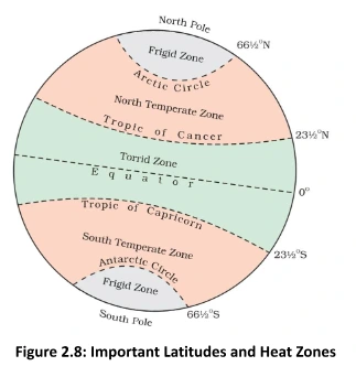
Latitude and longitude are fundamental geographic coordinates used to pinpoint any location on Earth’s surface. Latitude measures a location’s distance north or south of the equator, while longitude indicates its position east or west of the prime meridian. These coordinates are crucial for navigation, mapping, and accurately locating places on our planet.

Earth: Our Habitable Blue Planet in the Solar System

  • Earth’s Position in the Solar System: The earth is the 3rd nearest planet to the sun and 5th largest planet in size. 
  • Geoid Shape: It is slightly flattened at the North and the South Poles and bulges in the middle. That is why its shape is described as a Geoid which means an earth-like shape.
  • Habitability and Life Support: The earth is neither too hot nor too cold. It has water and air (life supporting gasses like oxygen), which are very essential for our survival. 
  • The Blue Planet: From outer space, the earth appears blue because its 2/3rd  surface is covered by water. It is, therefore, called a blue planet
  • Solar Dependence: It gets all its heat and light from the sun, which is our nearest star. 

Globe

  • These may be of varying size and type – big ones, which cannot be carried easily, small pocket globes, and globe-like balloons, which can be inflated and are handy.
  • It is not fixed and can be rotated.
  • On the globe, countries, continents and oceans are shown in their correct size.

Latitude and Longitudes: Navigating the Earth’s Axis and Equator

To find the location of places on the Earth we need certain points of reference and lines. 

  • These lines are called latitudes and longitudes. 
  • Axis: It is a tilted imaginary line passing through two poles, North Pole and South Pole and the earth moves around this axis. 
    • Aryabhatta, an ancient astronomer had stated that ‘the earth is round and rotates on its own axis’.
  • Equator: An imaginary circular line which divides the earth into two equal parts, the northern half (known as the Northern Hemisphere) and the southern half (known as the Southern Hemisphere)

Latitudes: Exploring Parallel Circles, Measurement, and Significance on Earth’s Surface

  • Parallels: All parallel circles from the equator up to the poles are called parallels.
  • Measurement in Degrees: They are measured in degrees and the equator represents the zero degree latitude. 
  • Equatorial Distance: Since the distance from the equator to either of the poles is 1/4th of a circle round the earth, it will measure 1/4th of 360° i.e. 90°. 
  • Polar: Thus, 90° north latitude marks the North Pole and 90° south lines marks the South Pole. 
  • North and South lines: All parallels north of the equator are called ‘north latitudes.’ and all parallels south of the equator are called ‘south latitudes.’
  • Latitudinal Significance: The value of each line is, therefore, followed by either north (N) or south (S). For example, Chandrapur in Maharashtra (India) and Belo Horizonte in Brazil (South America) are situated at 20° N latitude and 20° S latitude respectively. 
  • Changing Size: As we move away from the equator, the size of the parallels decreases but the distance between each is constant (Refer Figure 2.7). 

Do You Know:

By measuring the angle of the Pole Star from your place, you can know the latitude of your place.

Important Parallels of Latitudes

  • Tropic of Cancer (23½° N) in the Northern Hemisphere. 
  • Tropic of Capricorn (23½° S) in the Southern Hemisphere. 
  • Arctic Circle at 66½° north of the equator. 
  • Antarctic Circle at 66½° south of the equator (Refer Figure 2.8). 

Important Parallels of Latitudes

Heat Zones of the Earth

  • Torrid Zone: The mid-day sun is exactly overhead at least once a year on all latitudes in between the Tropic of Cancer and the Tropic of Capricorn
    • This area, therefore, receives the maximum heat and is called the Torrid Zone. 
  • Temperate Zones: The mid-day sun never shines directly overhead beyond the Tropic of Cancer and the Tropic of Capricorn. 
    • The angle of the sun’s rays goes on decreasing towards the poles. 
    • As such, the areas bounded by the Tropic of Cancer and the Arctic Circle, and the Tropic of Capricorn and the Antarctic Circle, have moderate temperatures are, therefore, called Temperate Zones. 
  • Frigid Zones: Areas lying between the Arctic Circle and the North Pole and the Antarctic Circle and the South Pole, are very cold. 
    • It is because here the sun does not rise much above the horizon, its rays are always slanting and provide less heat. 
    • These are, therefore, called Frigid Zones (very cold) (Figure 2.8). 

Longitude and Time: Earth’s Equal-Length Meridians and Time Measurement

  • Meridians of Longitude: They are semicircles running from the North Pole to the South Pole and the distance between them decreases steadily polewards until it becomes zero at the poles, where all the meridians meet. 
  • Measurement in Degrees: These lines of references are called the meridians of longitude, and the distances between them are measured in ‘degrees of longitude.’
    • Each degree is further divided into minutes, and minutes into seconds. 
  • Equal-Length Meridians: Unlike parallels of latitude, all meridians are of equal length (Refer Figure 2.9). 
  • Prime Meridian: Its value is 0° longitude which passes through Greenwich, where the British Royal Observatory is located and from it we count 180° eastward as well as 180° westward. 
  • The Prime Meridian and 180° meridian divide the earth into two equal halves, the Eastern Hemisphere (E) and the Western Hemisphere (W)
  • Both 180° East and 180° West meridians are on the same line. 
  • Longitude and Time: The best means of measuring time is by the movement of the earth, the moon and the planets. Local time can be reckoned by the shadow cast by the sun, which is the shortest at noon and longest at sunrise and sunset. 
    • When the Prime Meridian of Greenwich has the sun at the highest point in the sky, all the places along this meridian will have midday or noon. 
    • As the earth rotates from west to east, those places east of Greenwich will be ahead of Greenwich time and those to the west will be behind it. 
    • All the places on a given meridian have the same local time. 

Longitude

Time Zone

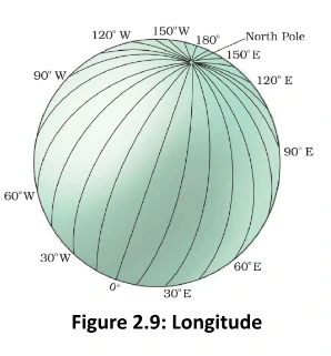
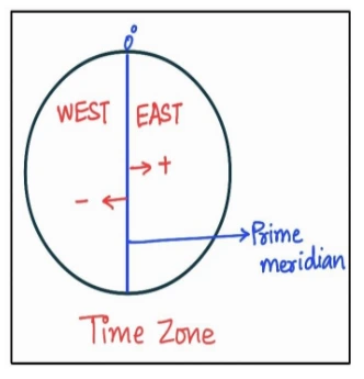
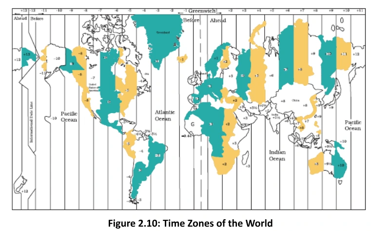
The earth has been divided into 24 time zones of one hour each and each zone covers 15° of longitude. In other words, the earth rotates 360° in about 24 hours, which means;
1 hour :- 15° or 4 minutes:-  1°When it is 12 noon at Greenwich,

  • The time at 15° east of Greenwich will be 15 x 4 = 60 minutes, i.e., 1 hour ahead of Greenwich time, which means 1 p.m.
  • But at 15° west of Greenwich, the time will be behind Greenwich time by one hour, i.e., it will be 11.00 a.m.
  • Similarly, at 180°, it will be midnight.

Indian Standard Material

Standard Time and Time Zones: Establishing Uniformity Across Meridians

Standard Time and Time Zones

  • Need for Standard Time: The local time of places which are on different meridians are bound to differ. For example, it will be difficult to prepare a time-table for trains which cross several longitudes. In India, for instance, there will be a difference of about 1 hour and 45 minutes in the local times of Dwarka in Gujarat and Dibrugarh in Assam. It is, therefore, necessary to adopt the local time of some central meridian of a country as the standard time for the country. 
  • Indian Standard Time (IST): In India, the longitude of 82½° E (82° 30′ E) is treated as the standard meridian. The local time at this meridian is taken as the standard time for the whole country and is known as the Indian Standard Time (IST). India located east of Greenwich at 82°30′ E is 5 hours and 30 minutes ahead of GMT (Refer Figure 2.11).
  • Some countries have a great longitudinal extent and so they have adopted more than one standard time. For example, Russia has eleven standard times (Refer Figure 2.10).

 Final Result – CIVIL SERVICES EXAMINATION, 2023.   Udaan-Prelims Wallah ( Static ) booklets 2024 released both in english and hindi : Download from Here!     Download UPSC Mains 2023 Question Papers PDF  Free Initiative links -1) Download Prahaar 3.0 for Mains Current Affairs PDF both in English and Hindi 2) Daily Main Answer Writing  , 3) Daily Current Affairs , Editorial Analysis and quiz ,  4) PDF Downloads  UPSC Prelims 2023 Trend Analysis cut-off and answer key

THE MOST
LEARNING PLATFORM

Learn From India's Best Faculty


 Final Result – CIVIL SERVICES EXAMINATION, 2023.   Udaan-Prelims Wallah ( Static ) booklets 2024 released both in english and hindi : Download from Here!     Download UPSC Mains 2023 Question Papers PDF  Free Initiative links -1) Download Prahaar 3.0 for Mains Current Affairs PDF both in English and Hindi 2) Daily Main Answer Writing  , 3) Daily Current Affairs , Editorial Analysis and quiz ,  4) PDF Downloads  UPSC Prelims 2023 Trend Analysis cut-off and answer key

Quick Revise Now !
AVAILABLE FOR DOWNLOAD SOON
UDAAN PRELIMS WALLAH
Comprehensive coverage with a concise format
Integration of PYQ within the booklet
Designed as per recent trends of Prelims questions
हिंदी में भी उपलब्ध
Quick Revise Now !
UDAAN PRELIMS WALLAH
Comprehensive coverage with a concise format
Integration of PYQ within the booklet
Designed as per recent trends of Prelims questions
हिंदी में भी उपलब्ध

<div class="new-fform">


    </div>

    Subscribe our Newsletter
    Sign up now for our exclusive newsletter and be the first to know about our latest Initiatives, Quality Content, and much more.
    *Promise! We won't spam you.
    Yes! I want to Subscribe.