Win up to 100% Scholarship

Register Now

Nepal Earthquake: Vulnerability, Resilience and Preparedness

PWOnlyIAS November 04, 2023 12:10 3707 0

Context: Recently, an earthquake of magnitude 6.4 struck western Nepal on 03 November night, resulting in the death of at least 132 deaths.

Nepal Earthquake: Vulnerability, Resilience and Preparedness

Context: Recently, an earthquake of magnitude 6.4 struck western Nepal on 03 November night, resulting in the death of at least 132 deaths.

Nepal Earthquake: 6.4 Richter Earthquake Strikes in Nepal

  • Magnitude and Location of Nepal Earthquake: Strong tremors were felt far away in the Nepalese capital and in cities in neighbouring India, including Delhi.
    • US Geological Survey measured the earthquake at a magnitude of 5.6, and said it was a shallow earthquake, meaning it happened closer to the earth’s surface.
  • Previous Instance:Last month, a 6.3-magnitude earthquake was registered in the western district of Bajhang, resulting in injuries.
  • Frequency: Earthquakes are common in Nepal which is situated on the ridge where the Tibetan and Indian tectonic plates meet and advance two meters closer to one another every century which results in pressure which is released in the form of earthquakes.
    • Nepal is the 11th most earthquake-prone country in the world.
    • Nepal is situated along the Himalayas, where there is a lot of seismic activity.

Nepal’s Seismic Vulnerability: Understanding Vulnerabilities and Lessons from the 2015 Earthquake Tragedy

  • Location on a Convergent Boundary: Nepal is located on a convergent boundary, where the Indian and Eurasian tectonic plates collide. This collision causes stress and strain to build up in the crust, which is eventually released in the form of earthquakes.
  • Subduction Zone: Nepal is also located in a subduction zone, where the Indian Plate is sliding underneath the Eurasian Plate.  This subduction process further increases the stress and strain on the crust, and can also lead to Nepal earthquakes.
  • Poor building construction practices: Many buildings in Nepal are made of unreinforced masonry, which is not very strong and can easily collapse in an earthquake.
  • Remote and mountainous terrain: Much of Nepal is remote and mountainous, which can make it difficult to provide relief and assistance in the aftermath of an earthquake.
  • The 2015 earthquake in Nepal was a devastating example of the country’s vulnerability to earthquakes. The earthquake killed nearly 9,000 people and injured over 22,000 more.  It also destroyed or damaged over 800,000 homes and businesses.

About Earthquakes

  • An earthquake is a sudden release of energy in the Earth’s crust that creates seismic waves.
  • Understanding Earthquakes: Key Terminology and Concept
    • Focus: The focus, also known as the hypocentre, is the point within the Earth where an earthquake originates.
    • Epicenter: The point on the Earth’s surface directly above the focus or source of an earthquake.
    • Fault: A fracture in the Earth’s crust where two tectonic plates meet. 
    • Foreshocks: Smaller earthquakes that occur before the main earthquake in the same place.
    • Aftershocks: Smaller earthquakes that occur after a larger earthquake, as the Earth adjusts to the sudden movement. 
    • Seismograph: An instrument that measures and records ground motion caused by earthquakes. 
    • Seismology: The scientific study of earthquakes.
    • Seismic waves: The waves of energy that travel through the Earth’s crust and cause ground shaking during an earthquake.
P waves (Primary Waves) S waves (Secondary waves) Surface Waves
  • These are the fastest seismic waves and are the first to arrive at a seismic station. 
  • They are compression waves that move through the earth like sound waves.
  • They can travel through solid and liquid materials.
  • These are slower than P waves and arrive at a seismic station after the P waves. 
  • They are transverse waves that can only travel through solid materials and cause a shaking motion perpendicular to the direction of wave propagation.
  • These are the slowest seismic waves and travel along the Earth’s surface. 
  • They Cause the ground to shake in a rolling motion and are responsible for the majority of the ground shaking and damage caused by large earthquakes.
  • Diverse Causes of Earthquakes: Understanding the Earth’s Dynamic Forces
    • Plate tectonics: The movement of the Earth’s tectonic plates can cause earthquakes when the plates interact along plate boundaries. E.g. Nepal earthquake of 2015.
    • Volcanic activity: Earthquakes can occur when magma moves beneath a volcano, causing the ground to shake. E.g. Cotopaxi earthquake of 2002.
    • Human activity: Human activities, such as the injection of fluid into the ground for waste disposal, or the extraction of oil and gas from underground reservoirs, can induce earthquakes. E.g. Oklahoma earthquake of 2016.
    • Reservoir-induced earthquakes: The filling or emptying of large reservoirs, such as lakes or dams, can cause earthquakes as the weight of the water changes and affects the Earth’s crust. E.g. Koyna earthquake of 1967.
    • Glacial rebound: The movement of glaciers can cause earthquakes as they advance or retreat and cause changes in the Earth’s crust. E.g. New Madrid earthquakes of 1811.

Measuring Earthquakes: Understanding Magnitude and Intensity Scales

  • Measurement of earthquakes: The magnitude and intensity of an earthquake are two ways to measure its size and impact.
    • Magnitude: The magnitude of an earthquake is a measure of its energy release, and is determined from measurements of the seismic waves generated by the earthquake. 
      • The most commonly used scale for measuring earthquake magnitude is the Richter scale, which was developed in the 1930s. 
      • The Richter scale ranges from 0 to 9, with each increase in magnitude representing a tenfold increase in energy release.
    • Intensity: The intensity of an earthquake is a measure of its impact at a specific location, and is determined by the effects of the seismic waves on the ground, buildings, and people. 
      • The most commonly used scale for measuring earthquake intensity is the Modified Mercalli Intensity (MMI) scale, which ranges from I to XII.
      • The MMI scale takes into account factors such as the type of building construction, the height of the building, and the distance from the earthquake’s epicenter.
Richter Scale
  • It is a logarithmic scale which ranges from a value of 1 to a value of 10. 
  • With each increase in the magnitude of the earthquake, the amount of ground shaking increases by 10 times, and the amount of energy released increases 32-fold. 
  • It is most accurate for earthquakes that occur in the Earth’s shallow crust. 
  • It was originally developed by Charles Richter in 1935, and it is still widely used today
Moment Magnitude Scale
  • It is a more recent scale that was developed in the 1970s. 
  • It is based on the total energy released by the earthquake. 
  • It is more accurate than the Richter scale for measuring large earthquakes.
Modified Mercalli Intensity scale
  • It is a qualitative scale that is used to describe the effects of an earthquake at a particular location.
  • The MMI scale is a 12-point scale, with Roman numerals I to XII. 

The Devastating Impact of Earthquakes: Destruction and Environmental Consequences

  • Damage to life and property: Earthquakes of high magnitude cause total collapse of the entire structure/building. This is accompanied by disruption of underground pipelines and railway lines, collapse of dams which cause sudden floods that in turn endanger life and livelihood.
  • Changes in river courses: Sometimes river channels are blocked or their courses are changed due to the impact of earthquake. 
  • Tsunami and other associated disasters: Earthquakes cause Tsunamis which disrupts life in settlements of coastal areas. It sinks large ships. Example: Tsunami in Indonesia Tsunami near Sumatra coast had cost properties worth billions of rupee. 
  • Landslides and avalanches are also caused by Earthquakes.

Assessing India’s Vulnerability to Earthquakes: Risk Factors and Regional Patterns

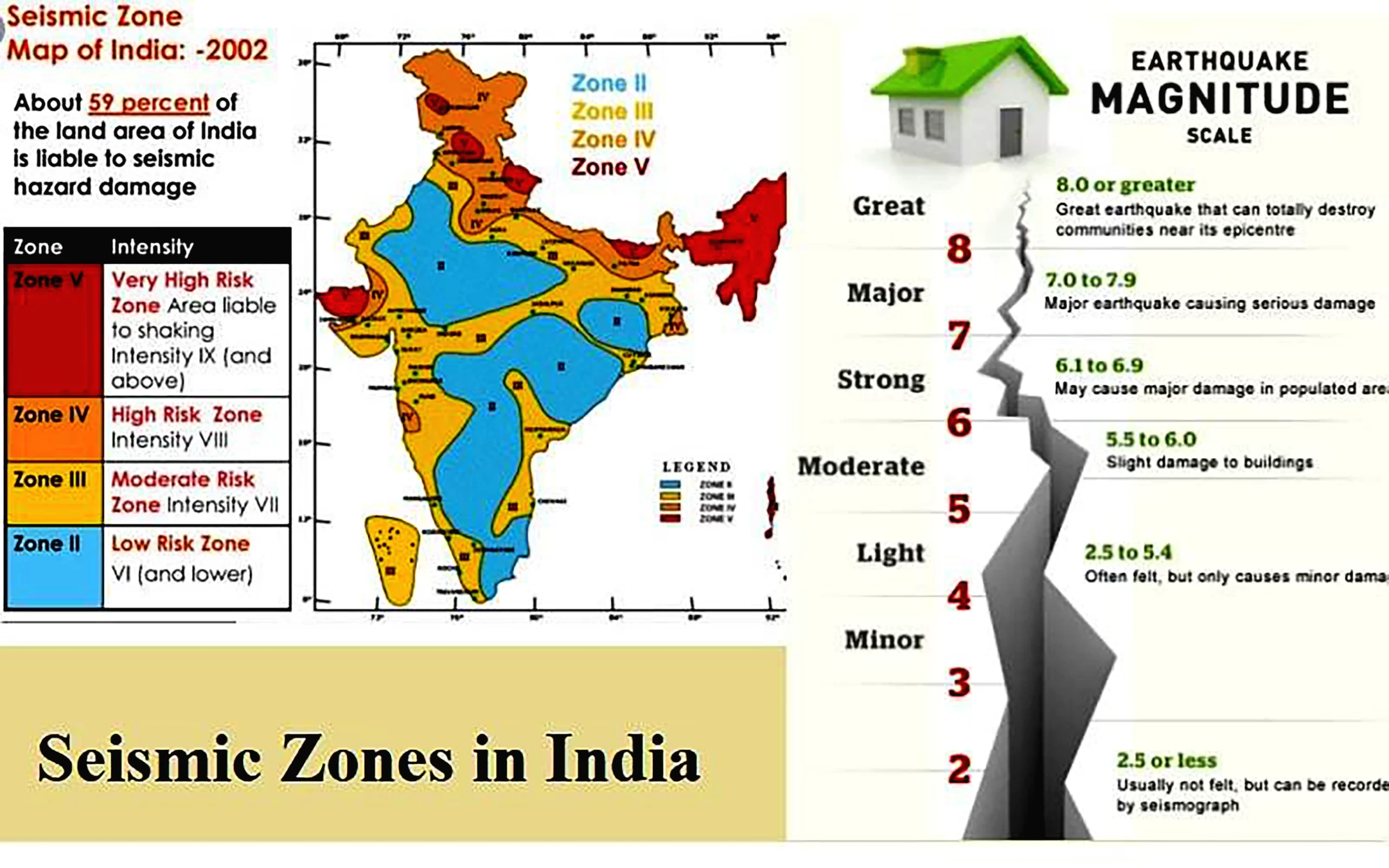
India’s large and increasing population coupled with unsustainable construction and planning that include multi-storeyed buildings and skyscrapers, keep India at high earthquake risk. 

  • Major Earthquakes: Over the past 2 decades, the country has experienced 10 major earthquakes that have resulted in over 20,000 deaths. 
  • Extent: As per the current seismic zone map of the country, over 59% of India’s land area is under threat of moderate to severe seismic hazard. 
    • NEPAL EARTHQUAKE Himalayan Belt: The entire Himalayan belt is considered prone to hazardous earthquakes of magnitude exceeding 8.0.
      • Example: 1897 Shillong Earthquake (M8.7); 1905 Kangra (M8.0); 1950 Assam-Tibet earthquake etc (M8.6). 
    • Himalayas is the region of convergence of Indian and Eurasian plates. 
      • The Indian plate is moving at a speed of one centimetre per year towards the north and northeastern direction. 
    • Inter Plate Boundaries: In the recent past, the inter-plate boundary areas have also been experiencing devastating earthquakes, although the magnitude is lesser than the Himalayan earthquakes. 
      • The Andaman and Nicobar Islands are situated on an inter-plate boundary and frequently experience damaging earthquakes. 
    • North-Eastern India: The North-Eastern part of the country continues to experience moderate to large earthquakes at frequent intervals.
      • On average, the region experiences an earthquake with a magnitude greater than 6.0 every year. 

Understanding India’s Earthquake Zones: Risks and Regional Classifications

India is divided into four earthquake zones (Zone II-Zone V).

  • There was a change in the earthquake map of India where Very low risk zone and Low risk zone were merged into single ‘low risk zone’. 

Seismic Zones in India

  • Zone IV and Zone V have experienced some of the most devastating earthquakes in India. 
    • These include North-east states, areas to the north of Darbhanga and Araria along the Indo-Nepal border in Bihar, Uttaranchal, Western Himachal Pradesh (around Dharamshala) and Kashmir Valley in the Himalayan region and the Kuchchh region of Gujarat. 
    • Most of the areas that are safe are from the stable landmass covered under the Deccan plateau. 

Enhancing Earthquake Resilience: Strategies for Mitigation and Preparedness in India

  • Establishing earthquake monitoring centres (seismological centres) for regular monitoring and fast dissemination of information among the people in the vulnerable areas. 
  • Preparing a vulnerability map of the country and dissemination of vulnerability risk information among the people and educating them about the ways and means to minimise the adverse impacts of disasters. 
  • Community preparedness: Community preparedness like ‘DROP, COVER and HOLD’ technique in case of earthquakes.
  • Planning: The Bureau of Indian Standards has published building codes and guidelines for safe construction of buildings against earthquakes. 
  • Public education is educating the public on causes and characteristics of an earthquake and preparedness measures that can be created through sensitization and training programmes for community, architects, engineers, builders, masons, teachers, government functionaries, teachers and students. 
  • Engineered structures: Buildings need to be designed and constructed as per the soil strength and building structures on soft soil should be avoided as they are more likely to get damaged even if the magnitude of the earthquake is not strong. 
    • Similar problems persist in the buildings constructed on the river banks which have alluvial soil. 
  • Strengthening the Preparedness Phase Urban Planning and Zoning -There is a need to enhance the efforts for integrating disaster risk reduction elements in settlement planning and land use zoning to mitigate flood and earthquake risks. 
  • Planned urban settlements and housing is the need of the day for disaster risk management that leads to sustainable development, particularly in ecologically sensitive regions, high risk locations and high population density pockets. 

Initiatives taken by the Government for Earthquake Risk reduction and Mitigation:

  1. National Earthquake Risk Mitigation Project (NERMP):
    • The proposed project aims at strengthening the structural and non-structural earthquake mitigation efforts and reducing the vulnerability in the high risk districts prone to earthquakes. 
    • The proposed components of the project include techno-legal regime, institutional strengthening, capacity building and public awareness etc.
  2. National Building Code (NBC):
    • The National Building Code of India (NBC), a comprehensive building code, is a national instrument providing guidelines for regulating the building construction activities across the country. 
    • The salient features of the revised NBC include meeting the challenges posed by natural calamities and reflecting the state-of-the-art and contemporary applicable international practices. 
  3. Efforts by Building Materials & Technology Promotion Council (BMTPC):
    • The BMTPC has undertaken projects for retrofitting of life-line structures for generating awareness among the people as well as various government agencies about the need and techniques of retrofitting. 
    • The Council has initiated retrofitting of MCD school buildings in Delhi. 
  4. Initiative by Ministry of Panchayati Raj: 
    • It releases funds under Backward Regions Grant Fund (BRGF) for meeting critical infrastructural gaps and other developmental requirements. 
    • The ministry has financed several district plans under the BRGF for construction of panchayat buildings, anganwadi centres, school buildings, class rooms, roads, bridges, culverts etc. 
  5. Disaster Management Support (DMS) of ISRO: This programme provides timely support and services from aero-space systems, both imaging and communications, towards efficient management of disasters in the country. The DMS programme addresses disasters such as flood, cyclone, drought, forest fire, landslide and Earthquake. These include:
    1. creation of digital data base for facilitating hazard zonation, damage assessment etc., 
    2. monitoring of major natural disasters using satellite and aerial data
    3. development of appropriate techniques and tools for decision support
    4. establishing satellite based reliable communication network
    5. deployment of emergency communication equipments and 
    6. R&D towards early warning of disasters. 
  6. Indian National Centre for Oceanic Information System (INCOIS): It gives information to all responders about the origin, time, location of the epicentre, magnitude and depth of an earthquake inside the ocean and accordingly issues bulletins. 
    • Tsunami Early Warning System (TEWS) at INCOIS is capable of detecting all earthquake events of more than 6 Magnitude occurring in the Indian Ocean in less than 20 minutes of occurrence.
    • First report on the occurrence of an earthquake in India and the Indian Ocean region is sent to MHA within 25-30 minutes indicating the location and magnitude of the earthquake. 

Role of Technology in Earthquake Preparedness:

  • Early Warning Systems: Advanced seismometer networks can issue early warnings to populations in earthquake-prone regions, giving people seconds to minutes of notice to take protective actions. 
  • Geospatial Information Systems (GIS): GIS technology helps in mapping and analysing fault lines and identifying high-risk areas. 
  • Cellular and Satellite Communication: for disseminating emergency information and coordinating rescue efforts. 
  • Social Media and Apps: for emergency alerts, communication, and sharing real-time information with the public.


Frequently Asked Questions

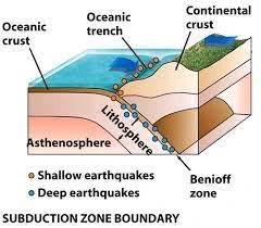
Nepal experiences earthquakes due to the collision of the Indian and Eurasian tectonic plates along its convergent boundary.

Nepal's vulnerability stems from its location on a convergent boundary, poor construction practices, and its position in a subduction zone, making it prone to seismic activity.

The focus is the point within the Earth where an earthquake originates, while the epicenter is the point on the Earth's surface directly above the focus.

Earthquakes are measured using magnitude scales like Richter and moment magnitude, and intensity scales like the Modified Mercalli Intensity (MMI) scale.

The Richter Scale measures earthquake magnitude on a logarithmic scale from 1 to 10, with each increase representing a tenfold energy release.

The National Building Code of India provides guidelines for regulating building construction activities and includes measures for natural calamities like earthquakes.

GIS technology helps map fault lines and identify high-risk areas prone to earthquakes, aiding in effective disaster preparedness and response planning.

TEWS at INCOIS detects earthquakes in the Indian Ocean, issuing timely bulletins to the Ministry of Home Affairs, enabling swift responses and effective disaster management.

Foreshocks are smaller earthquakes occurring before a main quake, whereas aftershocks are smaller tremors that follow a major earthquake.

Seismic waves generate ground shaking, damaging buildings and infrastructure, leading to potential collapses and other hazards.

Archive Calendar

Mon Tue Wed Thu Fri Sat Sun
1234567
891011121314
15161718192021
22232425262728
293031  

by month

 Final Result – CIVIL SERVICES EXAMINATION, 2023.   Udaan-Prelims Wallah ( Static ) booklets 2024 released both in english and hindi : Download from Here!     Download UPSC Mains 2023 Question Papers PDF  Free Initiative links -1) Download Prahaar 3.0 for Mains Current Affairs PDF both in English and Hindi 2) Daily Main Answer Writing  , 3) Daily Current Affairs , Editorial Analysis and quiz ,  4) PDF Downloads  UPSC Prelims 2023 Trend Analysis cut-off and answer key

THE MOST
LEARNING PLATFORM

Learn From India's Best Faculty


 Final Result – CIVIL SERVICES EXAMINATION, 2023.   Udaan-Prelims Wallah ( Static ) booklets 2024 released both in english and hindi : Download from Here!     Download UPSC Mains 2023 Question Papers PDF  Free Initiative links -1) Download Prahaar 3.0 for Mains Current Affairs PDF both in English and Hindi 2) Daily Main Answer Writing  , 3) Daily Current Affairs , Editorial Analysis and quiz ,  4) PDF Downloads  UPSC Prelims 2023 Trend Analysis cut-off and answer key

Quick Revise Now !
AVAILABLE FOR DOWNLOAD SOON
UDAAN PRELIMS WALLAH
Comprehensive coverage with a concise format
Integration of PYQ within the booklet
Designed as per recent trends of Prelims questions
हिंदी में भी उपलब्ध
Quick Revise Now !
UDAAN PRELIMS WALLAH
Comprehensive coverage with a concise format
Integration of PYQ within the booklet
Designed as per recent trends of Prelims questions
हिंदी में भी उपलब्ध

<div class="new-fform">


    </div>

    Subscribe our Newsletter
    Sign up now for our exclusive newsletter and be the first to know about our latest Initiatives, Quality Content, and much more.
    *Promise! We won't spam you.
    Yes! I want to Subscribe.