Books

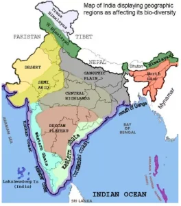
Plateaus in India are elevated flat landforms that form a major part of the country’s physical geography. The Deccan Plateau is the largest, while other important plateaus include Malwa, Chota Nagpur, Meghalaya, Bundelkhand, Baghelkhand, Telangana, and Karnataka Plateaus. These regions are rich in minerals, support agriculture, and play an important economic role.
Plateaus in India form one of the most important physical divisions of the country and occupy a large part of the Peninsular region. These elevated landforms play a key role in shaping India’s rivers, climate patterns, soil distribution, and mineral wealth. From the vast Deccan Plateau to smaller regions like Malwa, Chota Nagpur, and Meghalaya, the plateau regions of India geography reflect the country’s ancient geological history. Studying plateaus in India helps students understand natural resources, agricultural patterns, and economic development linked to these highland areas.
Plateaus in India are elevated landforms with generally flat or gently sloping surfaces. They stand distinctly above the surrounding terrain. These geological features are fundamental to India’s physical geography. They also carry significant importance for natural resources, agriculture, and historical development throughout the country.
Plateaus are distinct landforms withś several common characteristics.
Plateaus form through various geological processes. These processes occur over millions of years.
India hosts several significant plateaus, each with unique characteristics and importance. Here is a list of plateaus in India:
| Major Plateaus of India | ||
|---|---|---|
| Plateau Name | Location / Extent | Key Characteristics |
| Deccan Plateau | Southern India, south of Narmada River | Largest plateau, volcanic origin, rich black soil, bounded by Western and Eastern Ghats. |
| Malwa Plateau | Northwestern part of Deccan Plateau | Volcanic origin, fertile black soil, drained by Chambal River. |
| Chota Nagpur Plateau | Eastern India (Jharkhand, Odisha, Chhattisgarh) | Rich in minerals (coal, iron ore), rugged terrain, many rivers originate here. |
| Meghalaya Plateau | Northeastern India (Meghalaya) | Extension of Peninsular Plateau, separated by Ganga basin, high rainfall, karst landscape. |
| Bundelkhand Plateau | Central India (Uttar Pradesh, Madhya Pradesh) | Ancient crystalline rocks, low rainfall, rocky terrain, historical significance. |
| Baghelkhand Plateau | Eastern Madhya Pradesh | Limestone and sandstone rocks, drained by Son River, forested. |
| Telangana Plateau | Telangana, Andhra Pradesh | Undulating surface, granite rocks, drained by Godavari and Krishna tributaries. |
| Karnataka Plateau | Southern Deccan Plateau | Rolling plateau, granite composition, well-developed river valleys, known as Mysore Plateau. |
Check Out UPSC CSE Books
Visit PW Store
Plateaus in India are vital for the country’s economy due to various reasons.
The Peninsular Plateau of India divides into three main groups:
Ready to boost your UPSC 2026 preparation? Join PW’s UPSC online courses today!
Explore UPSC Test Series

A plateau is an elevated landform with a flat top and steep sides, rising significantly above the surrounding area.
The Deccan Plateau is the largest plateau in India, covering much of the southern peninsular region.
Plateaus are rich in mineral resources like coal and iron ore, offer fertile soil for agriculture (e.g., black soil for cotton), and provide sites for hydroelectric power generation from waterfalls.
The Deccan Plateau, Malwa Plateau, and Chota Nagpur Plateau are three major plateaus in India.
Plateaus form due to volcanic activity, tectonic uplift, and the differential erosion of rock layers.


Explore SRIJAN Prelims Crash Course

Connect with our experts to get free counselling & start preparing
Books
Udaan (Prelims Wallah)
Prahaar (Mains Wallah)
Q&A Bank (Prelims & Mains)
Budget & Economic Survey
NCERT Wallah
Marks Booster
हिंदी माध्यम विशेष शृंखला
 Current Affairs
Monthly Current Wallah
Subject Wise Current Affairs
Editorial Analysis
Editorial PDFs
News of The Day
Download Our App


Download Our App
<div class="new-fform">
</div>


 GS Foundation
 Optional Course
 Combo Courses
 Degree Program