The Peninsular Plateau, an ancient tableland, is rich in crystalline, igneous, and metamorphic rocks, shaping India’s landscape. Divided into the Deccan Plateau, Central Highlands, and Northeast Plateau, it hosts diverse physiographic features like tors, block mountains, and rift valleys. From the Western Ghats to the Eastern Ghats, this plateau spans regions like Maharashtra, Karnataka, and Kerala, offering a glimpse into India’s geological history.
An Overview of Peninsular Plateau in India
- Geological Composition: It is an ancient tableland composed of crystalline, igneous, and metamorphic rocks.
- General Elevation: is from west to east visible in the pattern of the flow of rivers.
- Extent: Delhi ridge in northwest (extension of Aravalis), Rajmahal hills in east, Gir range in west and Cardamom hills in south.
- Extension is also seen in the northeast: Meghalaya Plateau, Shillong and Karbi-Anglong plateau.
- Physiographic Features: tors, block mountains, rift valleys, spurs, series of hummocky hills and wall-like quartzite dykes (natural sites for water storage).
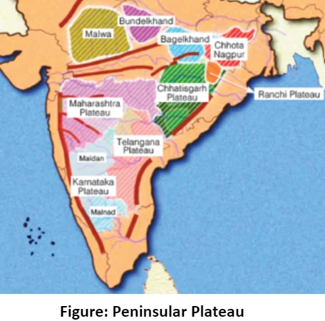
- Patland Plateaus: Hazaribagh plateau, Palamu plateau, Ranchi plateau, Malwa plateau, Coimbatore plateau and Karnataka plateau, etc.
- Geological Processes: Witnessed recurrent phases of upliftment and submergence, along with crustal faulting and fractures.
- Example: Bhima fault (Maharashtra) experiences recurrent seismic activity.
- Ravines: Northwestern part has ravines
- Example: Ravines of Chambal, Bhind and Morena.
- Black Soil: Western and northwestern parts have black soil.
Divisions of Peninsular Plateau
- Deccan Plateau: Satpura Range; Maharashtra Plateau;
- Karnataka- Dharwad Plateau;
- Telangana Plateau.
- Central Highlands: Aravalli Range; Mahabharat Uplands;
- Madhya Bharat Pathar;
- Bundelkhand;
- Vindhya Range;
- Malwa Plateau.
- Eastern Plateau: Baghelkhand, Garhjat Hills; Rajmahal Hills; Dandakaranya; Chotanagpur Plateau.
- Northeastern Plateau: Meghalaya Plateau.
- Western Ghats
- Eastern Ghats
- Classification based Prominent Relief Features: the Peninsular Plateau can be divided into three broad groups: Deccan Plateau, Central Highland and North -East Plateau.
A. The Deccan Plateau
-
- The Deccan Plateau is bordered by: Western Ghats (west), Eastern Ghats (east) and Satpura, Maikal range, and Mahadeo hills (north), extending southward from the Narmada River.
- Formation: It originated from volcanic activity, characterized by horizontal layers of solidified lava forming a unique trap structure.
- Features of the Deccan Plateau
-
-
- Area: Area of over 500,000 square kilometers, average elevation of 600 meters
- The plateau’s highest point is Doddabetta Peak in Tamil Nadu.
- Rivers on the Deccan Plateau: The general slope of the plateau is from west to east, as indicated by the flow of its major rivers. The Godavari, Krishna, and Kaveri rivers are significant rivers draining the plateau.
- Climate of the Deccan Plateau: Tropical climate, with hot and dry summers and milder winters. Rainfall averages around 600 millimeters per year, with the driest areas being Rayalaseema and Vidarbha.
- Significance of the Deccan Plateau
-
- Minerals: The plateau is rich in minerals and precious stones, attracting attention from ancient kingdoms like the Mauryans and Guptas.
- Agricultural Growth: While low precipitation historically made agriculture challenging, the introduction of irrigation systems has improved farming conditions, with crops like rice, sorghum, cotton, tobacco, and various spices being cultivated.
B. The Central Highlands
- General Elevation ranges between 700-1,000 m and it slopes towards the north and northeastern directions.
- Extent: Bounded by Aravali range(west); Satpura range forms the northernmost boundary of the Deccan plateau;
- Eastern Extension: is formed by the Rajmahal hills, to the south of which lies Chotanagpur plateau.
- The Central Highlands: are wider in the west but narrower in the east.
- The eastward extensions of this plateau are locally known as the Bundelkhand and Baghelkhand.
- Satpura Range is formed by a series of scarped plateaus on the south, generally at an elevation varying between 600-900 m above the mean sea level. Satpura ranges are highly denuded and form discontinuous ranges.
- The Peninsular plateau’s extension is as far as Jaisalmer in the west, where it is covered by crescent-shaped sand dunes known as Barchans and longitudinal sand ridges.
- Metamorphism: This region has witnessed metamorphic processes with presence of metamorphic rocks such as marble, slate,gneiss, etc.
- Vindhyan and Kaimur Ranges: are the source of the majority of the Yamuna river’s tributaries.
- The only significant tributary of the Chambal River that rises in the west (Aravalli) is the Banas.
- Aravalli Range: is the oldest fold of mountains. Sabarmati, Luni and Banas originate from here.
- Vindhya Range: extends from Gujarat to Bihar. It is a block mountain and source of Chambal, Sindh, Betwa and Ken.
- Malwa Plateau: is historically known as Khandesh.
- Chota Nagpur Plateau: has Rajmahal Hills in North East and Garhjat Hills on the southern edge.
C. The Northeastern Plateau
- It is an extension of the main Peninsular plateau. Northeastward movement of the Indian plate at the time of the Himalayan formation led to development of a huge fault (Malda gap) between Rajmahal hills and Meghalaya plateau that was later filled by river deposition.
- Extent: It includes Meghalaya, Karbi-Anglong Plateau and North Cachar Hills. Three prominent hill ranges from the west to the east are the Garo, the Khasi and the Jaintia Hills.
- Division: Meghalaya plateau is subdivided into three: Garo Hills, Khasi Hills and Jaintia Hills, named after local tribal groups.
- An extension of this plateau is observed in the Karbi Anglong hills of Assam.
- Kopili river separates Mikir, Regma and Barail hills from Meghalaya plateau.
- Mineral Resource: Meghalaya plateau is rich in mineral resources, including coal, iron ore, sillimanite, limestone, and uranium.
- Rainfall: This region receives maximum rainfall from the southwest monsoon, resulting in a highly eroded surface.
- Cherrapunji (Meghalaya plateau) has a bare rocky surface without a permanent vegetation cover due to heavy rainfall.
Conclusion
The Peninsular Plateau, with its remarkable relief features and diverse ecosystems, stands as a testament to India’s geological past and ecological richness. From the towering peaks of the Western Ghats to the rolling hills of the Northeast Plateau, this ancient land continues to shape India’s geography and support its biodiversity. It’s a special place full of amazing natural wonders, offering insights into the forces that have shaped our planet over millions of years.
 May 4, 2024