Books & Magazines

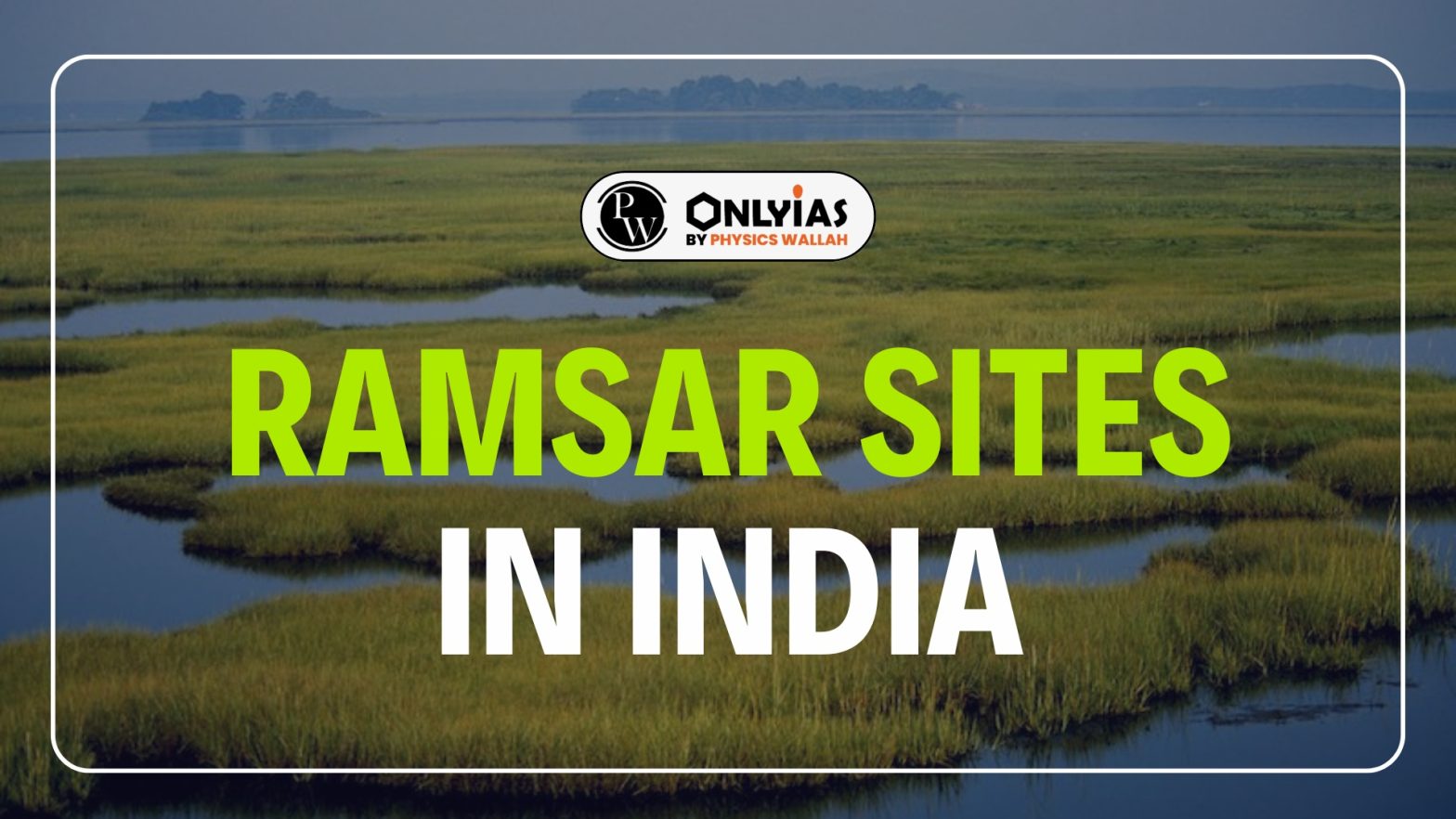
Ramsar Sites in India now total 91, following the latest additions of Khichan and Menar in Rajasthan. These Ramsar Sites in India span over 13 lakh hectares, ensuring ecological balance and global recognition.
| Review Aspect | Writer
(Yes / No) |
Proofreader
(Yes/No) |
| SEO & Keyword Usage | ||
| Primary keyword used naturally within the first 100 words | Yes | Yes |
| Secondary keywords added only where contextually relevant | Yes | Yes |
| Keyword Density: Depending Upon the word count
Primary keyword: ~0.8%–1% keyword density Secondary keyword: ~0.2%–0.5% keyword density |
Yes | Yes |
| No keyword stuffing or forced phrasing | Yes | Yes |
| Structure, Wireframe & Flow | Yes | Yes |
| Content strictly follows the approved wireframe under the H1 | Yes | Yes |
| TL;DR is present, having a summary of content under 50 words/350 characters | Yes | Yes |
| All H2 and H3 sections logically support the H1 | Yes | Yes |
| Overall content flow is clear and coherent | Yes | Yes |
| Introduction & Problem Statement | ||
| Introduction clearly highlights the learner’s problem | Yes | Yes |
| Introduction aligns with the H1 and page objective | Yes | Yes |
| Value proposition is clear in the opening section | Yes | Yes |
| Language, Tone & Readability | ||
| UK English used consistently (spelling and grammar) | Yes | Yes |
| Tone balances conversational and formal- Class 8th | Yes | Yes |
| Language is clear, neutral, and learner-focused | Yes | Yes |
| Accuracy, References & Credibility | ||
| Reference links used during research are shared | Yes | |
| No unsupported, exaggerated, or vague claims | Yes | |
| Brand Mention | ||
| Brand mention is relevant & natural | NA | |
| Value Addition vs Competitors | ||
| Specific value added beyond competitor content is clearly stated (what and where) | Yes (images of map) | |
| Quality & Compliance | ||
| Grammarly score screenshot attached (score ≥ 60) | Yes | Yes |
| Plagiarism report screenshot attached- 10% or below | Yes | Yes |
| Follow IPO Guidelines | Yes | Yes |
TL;DR: The Tapi River, also known as the Tapti River, is a major west-flowing River in central India. It originates in Madhya Pradesh, flows through Maharashtra and Gujarat, and empties into the Arabian Sea. The Tapi River system is vital for irrigation and industry in its basin, characterized by fertile black soils.
MD: The Tapi River, a major west-flowing river of India, originates in Madhya Pradesh and flows through Maharashtra and Gujarat. Learn about its basin, tributaries, dams, soils, and agricultural importance.
Slug- Tapi River
Banner- https://drive.google.com/open?id=1gNYOmyvsMUCJ7AALooj7EHxuY5K46yf8&usp=drive_copy
Tapi River, also called the Tapti River, is a major west-flowing River of central India. It originates from the Satpura Range in Madhya Pradesh, flows through Maharashtra and Gujarat, and finally drains into the Arabian Sea near Surat through the Gulf of Khambhat.
The Tapi River basin covers about 65,000 sq km and has fertile black soils and wide Tapi River flood plains, which support farming and settlements. Important tributaries, dams like Ukai, and irrigation projects make the River vital for agriculture, industries, and geography studies.
The Tapi River is one of the major Rivers of India that flows from east to west. It is also known as the Tapti River. This River and Tapi River map is very important for geography students because it is among the few Rivers that flow westward in India.
The Tapi River origin and course explain why this River is unique in Indian geography. The Tapi River is well known for its westward flow and rift valley path.
Also Read: Important Rivers In India
The Tapi River basin is an important physical region in western India. It supports forests, farms, and settlements across areas drained by the Tapi River.
The Tapi River has 14 major tributaries, each over 50 kilometers long. The left bank tributaries form a larger drainage system.
| Tapi River Tributaries | ||
|---|---|---|
| Bank | Major Tributaries | Key Points
|
| Left Bank | Purna, Girna, Panjhara, Bori, Waghur, Amravati, Buray, Nesu, Mona, Sipna | Purna is the largest tributary, with perennial flow. |
| Right Bank | Vaki, Aner, Arunawati, Gomai | Originate in the Satpura ranges. |
The Tapi River estuary is located near Surat in Gujarat, where the Tapi River meets the Gulf of Khambhat in the Arabian Sea. This west-flowing River, with a length of about 724 km, forms an estuary instead of a delta, which is rare in India.
The estuary is strongly affected by tides and supports mangroves, rich plant life, and many freshwater and marine animals. Because of its high tidal range and mixed water, the Tapi River estuary is a highly productive and important natural ecosystem.
The soil types in the Tapi River basin support rich farming activities. These soils play a major role in crop growth across areas covered by the Tapi River.
The Tapi River supports many major projects and industries across its basin. These Tapi River irrigation projects and industries play a key role in power generation, farming, and regional growth.
The Tapi River flow direction is an important feature in Indian geography. The Tapi River flows westward, which makes it different from most peninsular Rivers of India.
The Tapi River and its basin are agriculturally rich. The fertile black soils support diverse crops. Cotton, sugarcane, groundnut, and millets are common. Irrigation from projects like Ukai Dam and Hatnur Dam enhances productivity. These Tapi River irrigation projects make the valley a vital economic zone.
Ready to boost your UPSC preparation? Join PW’s UPSC online courses today!
Q1: Where does the Tapi River originate?
A1: The Tapi River originates at Multai in the Betul district of Madhya Pradesh, within the Satpura Range.
Q2: Which states does the Tapi River flow through?
A2: The Tapi River flows through Madhya Pradesh, Maharashtra, and Gujarat.
Q3: Why is the Tapi River considered the “twin” of the Narmada River?
Q3: It flows parallel to the Narmada River in a west-flowing rift valley and shares similar length and basin features.
Q4: What are the main types of soil found in the Tapi River basin?
Q4: The basin primarily consists of black soils, with alluvial clays and black soil layers found in Gujarat’s coastal plains.
Q5: Name an important dam on the Tapi River.
Q5: The Ukai Dam, located in Gujarat, is a significant project on the Tapi River, providing irrigation and hydropower.

There are a total of 91 Ramsar Sites in India as of June 2025.
Khichan and Menar in Rajasthan were added in June 2025.
Tamil Nadu has the highest number of Ramsar Sites in India.
Tamil Nadu leads among Indian states with 20 Ramsar Sites, followed by Uttar Pradesh with 10.
The total area is approximately 13,26,677 hectares.
The first Ramsar sites in India were Chilika Lake in Odisha and Keoladeo National Park in Rajasthan.
The largest Ramsar site in India is Sundarbans Wetland in West Bengal.
The smallest Ramsar site in India is Renuka Wetland in Himachal Pradesh, with an area of 0.2 sq. km.
The floating Ramsar site in India is Loktak Lake in Manipur, which is home to the world’s only floating national park, Keibul Lamjao National Park.


Connect with our experts to get free counselling & start preparing
Books & Magazines 
Prelims Wallah (Q&A Bank)
Udaan
Udaan 500+
Budget & Economic Survey
Monthly Current Wallah
Weekly Current Wallah
Editorial Summary
Editorial Q&A Compilation
NCERT Wallah
Prahaar (Mains Wallah)
Marks Booster
Mains Wallah (Q&A Bank)


<div class="new-fform">
</div>
 GS Foundation
 Crash Course
 Combo
Combo Optional Courses
 Degree Program