NCERT NOTES

Elevate your UPSC preparation with NCERT Notes – because every word matters on your journey to success.

Geographical Diversity in the Structure and Physiography of Earth’s Transformations

June 20, 2024 2152 0

Geographical Diversity: A Transformative Journey

The Earth has transformed over time due to endogenic and exogenic forces shaping its surface and subsurface features. For instance, The Indian plate, once located south of the equator and part of a larger entity including the Australian plate, fragmented over millions of years. The Australian plate moved southeastward, while the Indian plate moved northward, a movement that continues today. 

This resulted in the creation of the region’s present geological features and divisions, showcasing the geographical diversity of India. In this Article, these geological and physiographic divisions of India will be discussed.
How is Geographical Diversity Reflected in India’s Major Geological Divisions, Particularly the Himalayas and Peninsular Mountains?

  •  India’s Diverse Physical Features: India encompasses all major physical features found on Earth. 
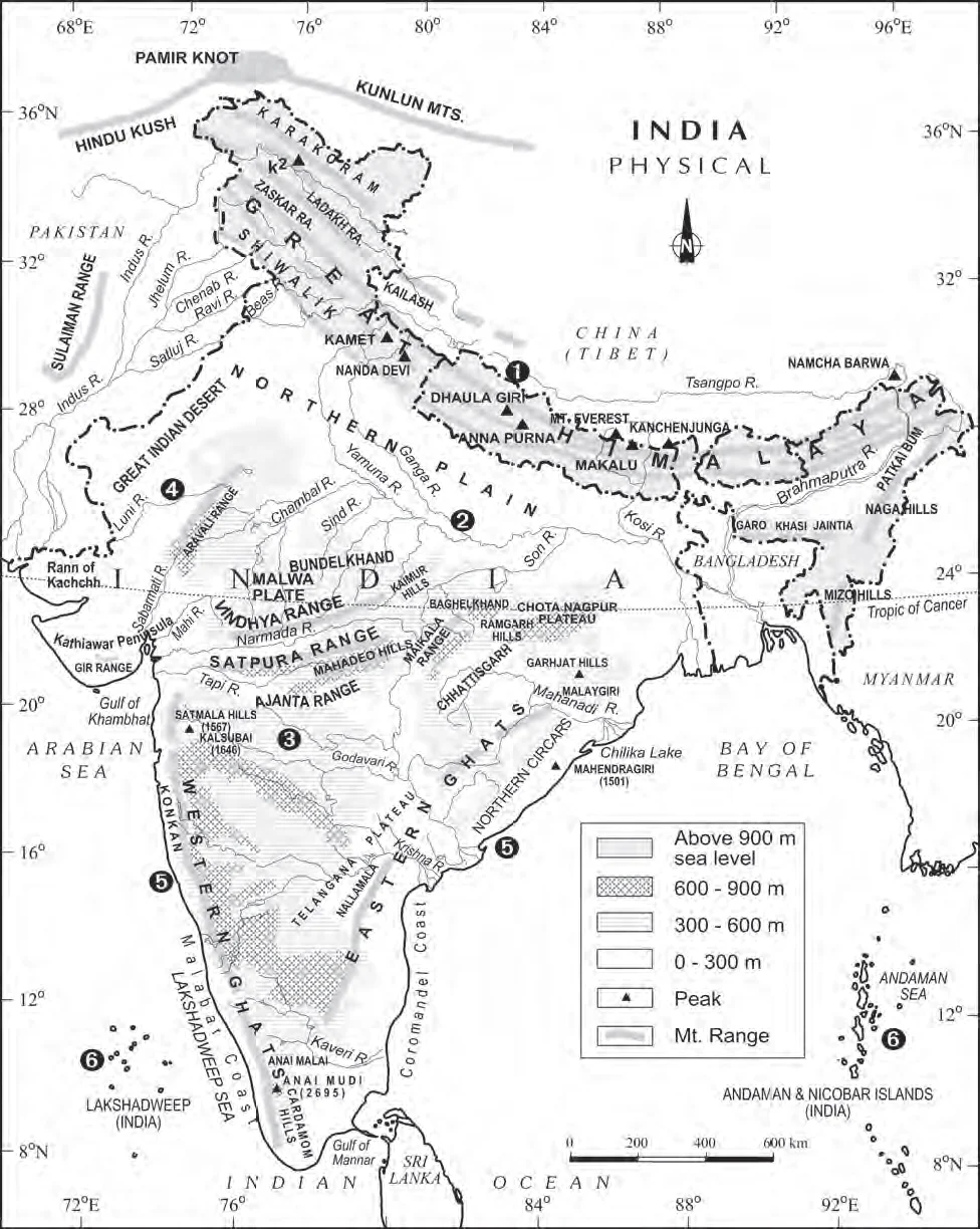
    • The country’s land exhibits remarkable physical variations(Refer Figure). 
  • Geological Divisions of India: This northward shift of the Indian plate profoundly impacted the Indian subcontinent’s physical environment, leading to the development of the following geological divisions of India. 
    • The Himalayas and other Peninsular Mountains, 
    • The Indo-Ganga-Brahmaputra Plain.
  • The Peninsular Block

Physical Features of India

Physical Features of India

Geographical Diversity in the Himalayas and Peninsular Mountains:

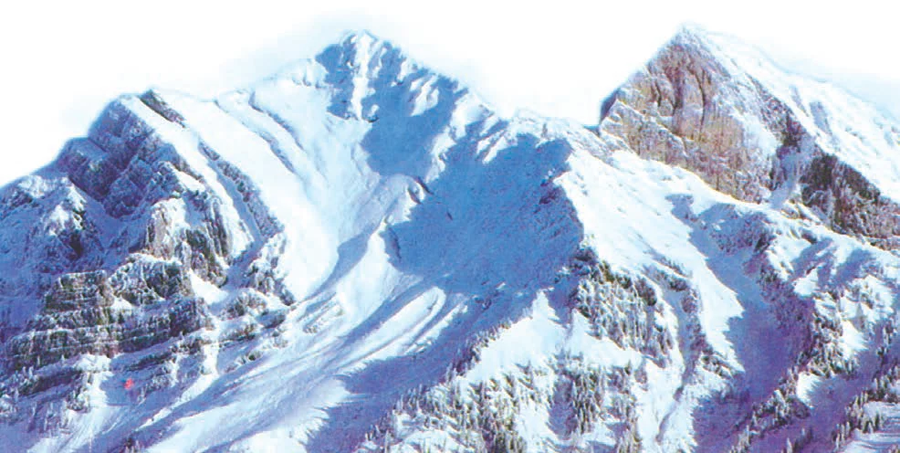
  • Geographical Extent: India’s Impressive Northern Frontier: Stretching Across India’s Northern Frontiers The Himalayas, a geologically young and impressive fold mountain range, stretch across India’s northern borders.
    • This mountain system extends from the Indus River in the west to the Brahmaputra River in the east, covering approximately 2,400 kilometers (Refer Figure).
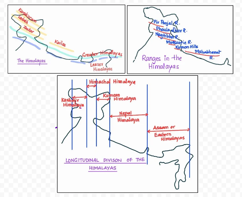
  • Himalayan Ranges: Himadri, Himachal, and Shiwaliks: The Himalayas consist of three main parallel ranges: the Great Himalayas (Himadri), Lesser Himalayas (Himachal), and Shiwaliks, which we will study in subsequent sections.

The Himalayas

The Himalayas

What is the Geographical Diversity in the Extent and Composition of the Indo-Ganga-Brahmaputra Plain?

  • Geographical Extent: River-Formed Plains: It is the third geological division of India consisting of vast plains formed by the Indus, Ganga, and Brahmaputra rivers. 
  • Composition: Originally, this area was a geo-synclinal depression that reached its peak development approximately 64 million years ago during the third phase of the Himalayan mountain formation. 
    • Over time, these plains have been gradually filled with sediments carried by the Himalayan and Peninsular rivers. 
    • The alluvial deposits in these plains have reached an average depth ranging from 1,000 to 2,000 meters. 

How Does the Peninsular Block Showcase Geographical Diversity?

  • Geographical Extent and Geographical Diversity of the Peninsular Block: It is defined by its northern boundary as an irregular line extending from Kachchh along the western flank of the Aravali Range near Delhi, and 
    • Continuing roughly parallel to the Yamuna and the Ganga until reaching the Rajmahal Hills and the Ganga delta, 
    • It also encompasses extensions like Karbi Anglong, Meghalaya, and Rajasthan.
  • Composition: Composed mainly of ancient gneisses and granites, this region has remained stable since the Cambrian period despite tectonic activity.
  • Geological Features and Rift Valleys of the Peninsular Block: As part of the larger Indo-Australian Plate, it has experienced various vertical movements and block faulting. 
    • Rift Valleys: Notable geological features include rift valleys like the Narmada, Tapi, and Mahanadi, along with the presence of Satpura block mountains and 
    • Mountain Ranges: Various mountain ranges such as Aravali, Nallamala, Javadi, Veliconda, Palkonda, and Mahendragiri.
    • Formation of Deltas: Additionally, the area’s east-flowing rivers create shallow valleys and form significant deltas, such as those of the Mahanadi, Krishna, Kaveri, and Godavari. 
    • Coastal Changes: Tectonic activity has led to coastal changes, submerging parts of the western coast while sparing the original basement.
  • These geological variations significantly impact the physiography and relief of different regions in India, as geological and geomorphological processes shape the subcontinent’s landscape.

How is India’s Physiography Shaped by Geographical Diversity?

Physiography, the result of geological structure, ongoing processes, and developmental stages, showcases India’s diverse physical features. 

  • In the north, an expansive rugged landscape unfolds with a series of mountain ranges, diverse peaks, picturesque valleys, and deep gorges.
  • Contrasting this, the south comprises stable table lands characterized by dissected plateaus, exposed rocks, and prominent scarps. 
  • Between these regions lies the extensive North Indian Plain, highlighting India’s rich physiographic diversity. 
  • Based on these macro variations, India can be divided into the following physiographic divisions:

 (1) The Northern and North-eastern Mountains

 (2) The Northern Plain

 (3) The Peninsular Plateau

 (4) The Indian Desert

 (5) The Coastal Plains 

 (6) The Islands. 
What Role Does Geographical Diversity Play in the Majesty of the Northern and Northeastern Mountains in India?

  • The North and Northeastern Mountains encompass the Himalayas, a series of parallel mountain ranges. Notable among these are the Greater Himalayan range, including the Great Himalayas and the Shiwalik.

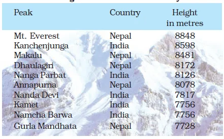
Some Of The Highest Peaks Of The Himalayas

Some Of The Highest Peaks Of The Himalayas

  • Geographical Extent: Himalayan Ranges from Northwest to Southeast: These ranges generally run from northwest to southeast in northwestern India,
    • While Darjeeling and Sikkim’s Himalayas stretch east to west. 
    • In Arunachal Pradesh, they extend southwest to northwest, and 
    • In Nagaland, Manipur, and Mizoram, they align north-south. 

POINTS TO PONDER

The Himalayas exhibit a pattern when we move from west to east. The Peaks start getting higher and the horizontal distance between the three Himalayan ranges i.e. Upper, middle and lower start diminishing and the distinction among the three starts fading away. Can you find out the reason for the same?

  • Size: The Great Himalayan range: at approximately 2,500 km in length from east to west and varying from 160-400 km in width from north to south,
  • Himalayas as a Natural Barrier: With this extent, it acts as a formidable natural barrier separating the Indian subcontinent from Central and East Asian countries. 
  • The Geological Characteristics of the Himalayas and Peninsular Mountains: The Himalayas along with other Peninsular mountains are young, weak and flexible in their geological structure, unlike the rigid and stable Peninsular Block. 
    • Consequently, they are still subjected to the interplay of exogenic and endogenic forces, resulting in the development of faults, folds and thrust plains.

Himalaya Division based on Longitudinal Extent, Its Size and Composition

  • Himalaya Division based on Longitudinal Extent, Its Size and Composition: 
    • The Great Himalayas: These are the loftiest, with peaks averaging around 6,000 meters and composed of granite. 
      • Prominent peaks are found here.
    • Lesser Himalayas: These are rugged and composed of highly compressed rocks, including ranges like Pir Panjal, Dhaula Dhar, and Mahabharat
      • They encompass well-known valleys like Kashmir and Himachal Pradesh.
    • The Shiwaliks: The outermost range, has an altitude ranging from 900 to 1100 meters and is composed of sediments brought by rivers from the main Himalayan ranges to the north. 
      • These valleys are covered in thick gravel and alluvium.
    • Duns-Longitudinal Valleys: It is situated between the Lesser Himalayas and Shiwaliks are known as Duns
      • Examples: It includes Dehradun, Kotli Dun, and Patli Dun.
  • Himalayan Divisions: River Valleys from West to East:  The Himalayas have been divided on the basis of regions from west to east.
    • It includes Punjab Himalayas ( between Indus and Satluj ), Kumaon Himalayas (between Satluj and Kali) , Nepal Himalayas (Between  Kali and Teesta), and Assam Himalayas  (Between Teesta and Dihang).
  • Eastern Boundary and Beyond: The eastern boundary of the Himalayas is marked by the Brahmaputra River, which extends further as the Purvanchal or Eastern hills.
  • Influence Beyond Physical Presence: Beyond its physical presence, the Himalayas also influence climate, drainage, and cultural distinctions.
Must Read
Current Affairs Editorial Analysis
Upsc Notes  Upsc Blogs 
NCERT Notes  Free Main Answer Writing

Need help preparing for UPSC or State PSCs?

Connect with our experts to get free counselling & start preparing

THE MOST
LEARNING PLATFORM

Learn From India's Best Faculty

      
Quick Revise Now !
AVAILABLE FOR DOWNLOAD SOON
UDAAN PRELIMS WALLAH
Comprehensive coverage with a concise format
Integration of PYQ within the booklet
Designed as per recent trends of Prelims questions
हिंदी में भी उपलब्ध
Quick Revise Now !
UDAAN PRELIMS WALLAH
Comprehensive coverage with a concise format
Integration of PYQ within the booklet
Designed as per recent trends of Prelims questions
हिंदी में भी उपलब्ध

<div class="new-fform">


    </div>

    Subscribe our Newsletter
    Sign up now for our exclusive newsletter and be the first to know about our latest Initiatives, Quality Content, and much more.
    *Promise! We won't spam you.
    Yes! I want to Subscribe.