NCERT NOTES

Elevate your UPSC preparation with NCERT Notes – because every word matters on your journey to success.

River Systems of India: Brahmaputra and Peninsular Drainage Overview

June 20, 2024 4879 0

Brahmaputra: Tracing the River System from Glacier Source to Catchment Challenges:

The Brahmaputra River, one of the largest rivers globally, originates from the Chemayungdung glacier in the Kailash range near Mansarovar Lake

  • The Brahmaputra River is notorious for its frequent floods, channel shifts, and bank erosion.
  • This phenomenon is primarily a result of its large tributaries, which carry substantial sediment loads due to heavy rainfall in the river’s catchment area.

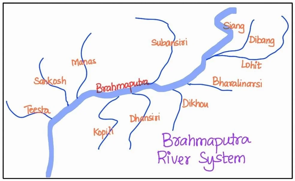
Brahmaputra river system

Brahmaputra: River System’s Evolution from Tibet to the Bay of Bengal

  • Tibetan origins: Following the Brahmaputra River’s Tsangpo Phase: The Tsangpo Phase Initially, it flows eastward longitudinally for approximately 1,200 km in a dry and flat region of southern Tibet, where it is known as the Tsangpo, meaning “the purifier.”
    • In Tibet, the Rango Tsangpo serves as the major right-bank tributary of this river.
  • Formation of the Dynamic River: From Himalayan Gorge to the Siang or Dihang River: The Brahmaputra transforms into a turbulent and dynamic river after carving a deep gorge in the Central Himalayas, particularly near Namcha Barwa.
  • As it exits the foothills of the Himalayas, the river adopts the name Siang or Dihang.
  • Entry into India: It enters India to the west of Sadiya town in Arunachal Pradesh.
    • As it flows southwestward, the Brahmaputra receives its main left bank tributaries, including the Dibang or Sikang and Lohit rivers. 
    • Following these confluences, it is recognized as the Brahmaputra River.
    • As the Brahmaputra River enters Bangladesh near Dhubri, it flows southward. 
  • In Bangladesh, it is joined on its right bank by the Tista River, after which it is referred to as the Jamuna River
  • Eventually, it merges with the Padma River, which ultimately falls into the Bay of Bengal.

Brahmaputra’s Tributaries: A Comprehensive Look at River Systems in Assam Valley

  • The Brahmaputra River, during its journey through the Assam valley, receives numerous tributaries. 
  • Among its major left-bank tributaries are the Burhi Dihing and Dhansari (South), while important right-bank tributaries include the Subansiri, Kameng, Manas, and Sankosh rivers.
  • The Subansiri River, originating in Tibet, is characterized as an antecedent river in this intricate river system.

The Peninsular Drainage System: An In-Depth Look at the River Systems

What role do River Systems Play in defining the characteristics of the Peninsular Drainage System?

  • Chronicles of Time: Evolution of Peninsular Drainage: The Peninsular drainage system is older than the Himalayan one, which is evident from the characteristics of the rivers and the landscape.
  • Valleys of Maturity: Examining the Characteristics of Peninsular River Courses: The Peninsular drainage system features broad, mostly graded shallow valleys, and the rivers exhibit maturity in their courses.

POINTS TO PONDER

Prominent rivers of Peninsular India like Godavari, Krishna and Kaveri flow towards the East into the Bay Of Bengal. What do you think are the reasons behind this? However, there is also a paradox of some west flowing rivers, prominent amongst which are Narmada, Tapi etc. Can you figure out the reason for this?

  • Watershed Wonders: The Role of Western Ghats in Peninsular Drainage: The Western Ghats, which run parallel to the western coast, serve as the watershed between the major Peninsular rivers, which ultimately discharge their waters into the Bay of Bengal, and the smaller rivulets that flow into the Arabian Sea.
  • Eastward Bound: Understanding the Flow Patterns of Peninsular Rivers: Most of the significant Peninsular rivers except Narmada and Tapi, flow from west to east.
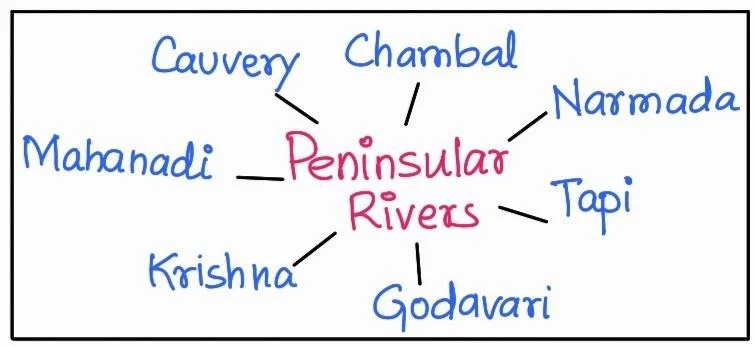
  • Ganga Connections: Tracing the Northern Tributaries in Peninsular India: The Chambal, Sind, Betwa, Ken, and Son, originating in the northern part of the Peninsula, are part of the Ganga river system. 

Peninsular river

  • Significant River Systems of Peninsular Drainage: Other major river systems in the Peninsular drainage include the Mahanadi, Godavari, Krishna, and Kaveri.
  • Fixed Courses and Perennial Patterns in Peninsular Rivers: Peninsular rivers are characterised by their fixed courses, the absence of meanders, and the non-perennial flow of water, although the Narmada and Tapi, which flow through rift valleys, are exceptions to this pattern.

Dynamic Forces and River Systems: Geological Evolution of Peninsular Drainage

Three major geological events in the distant past have played a crucial role in shaping the present drainage systems of Peninsular India:

  • Subsidence Saga: Tectonic Shifts in the Western Flank: During the early Tertiary period, the western flank of the Peninsula subsided below sea level. 
  • This event disrupted the symmetrical plan of the rivers on either side of the original watershed.
  • Himalayan Impact: Trough Faulting and the Narmada-Tapi Transformation: The uplift of the Himalayas caused subsidence on the northern flank of the Peninsular block, leading to trough faulting. 
  • The Narmada and Tapi rivers flow in these trough faults and have filled the original cracks with their detritus materials. 
  • Consequently, there is a lack of alluvial and deltaic deposits in these rivers.
  • Tilting Tides: Geological Shifts and the Bay of Bengal Orientation: The Peninsular block experienced a slight tilting from northwest to southeast during the same period. 
  • This tilting gave the entire drainage system an orientation towards the Bay of Bengal.

These geological events have had a profound impact on the flow patterns and characteristics of the rivers in Peninsular India.

Peninsular River Systems: Chronicles of the Mahanadi, Godavari, Krishna, Kaveri, Narmada, Tapi, and Luni

Mahanadi River: A Lifeline of Chhattisgarh and Odisha

  • Origin: The Mahanadi River originates near Sihawa in the Raipur district of Chhattisgarh.
  • Course: It flows through the state of Odisha, traversing a total length of 851 kilometres.
  • Catchment Area: The Mahanadi River has a vast catchment area that covers approximately 1.42 lakh square kilometres.
  • Navigation: Some navigation activities are carried out in the lower course of the river.
  • Drainage Basin: The drainage basin of the Mahanadi is distributed as follows: 53 percent of it lies in the states of Madhya Pradesh and Chhattisgarh, while the remaining 47 percent is located in Odisha
  • The Mahanadi River ultimately discharges its waters into the Bay of Bengal.

POINTS TO PONDER

The Indian landscape is rich and blessed with adequate water resources. Despite this India has continued to be a  water stressed Nation for about a decade now. What can be the causes of this? Is the regional variation in water distribution the cause or is low water use efficiency the determinant factor? To what extent do you think that Inter-linking of Rivers can prove to be a solution?

Godavari River: The Mighty Flow of the Deccan Plateau

  • Origin: The Godavari River originates in the Nasik district of Maharashtra. It is the largest river system in the Peninsular drainage.
  • Course: It flows through several states, including Maharashtra, Madhya Pradesh, Chhattisgarh, Odisha, and Andhra Pradesh, before finally discharging its water into the Bay of Bengal.
  • Length: The Godavari is a lengthy river, stretching for about 1,465 kilometres.
  • Catchment Area: Its catchment area is extensive, covering approximately 3.13 lakh square kilometres.
  • Distribution: The distribution of the Godavari’s catchment area is as follows: 49 percent lies in Maharashtra, 20 percent in Madhya Pradesh and Chhattisgarh, and the rest in Andhra Pradesh.
  • Tributaries: The river has several significant tributaries, including the Penganga, the Indravati, the Pranhita, and the Manjra.
  • Delta: After Rajamundri, the river splits into several branches, forming a large delta before it enters the Bay of Bengal.

Krishna River: Originating from the Sahyadri Ghats

  • Origin: The Krishna river originates near Mahabaleshwar in the Sahyadri (Western Ghats).
  • Length: The total length of the Krishna river is approximately 1,401 kilometres.
  • Tributaries: It receives water from several major tributaries, including the Koyna, the Tungabhadra, and the Bhima.
  • Catchment Area: The Krishna river’s catchment area is quite extensive, with 27 percent of it in Maharashtra, 44 percent in Karnataka, and 29 percent in Andhra Pradesh and Telangana.

Kaveri River: Flow from the Brahmagiri Hills

  • Origin: The Kaveri river originates in the Brahmagiri hills, specifically in the Kodagu district of Karnataka
  • Length: It has a total length of approximately 800 kilometres.
  • Catchment Area: The Kaveri river basin covers an area of 81,155 square kilometres.
    • It spans across multiple states, with around 3 percent in Kerala, 41 percent in Karnataka, and 56 percent in Tamil Nadu.
  • Tributaries: The Kaveri has several important tributaries, including the Kabini, the Bhavani, and the Amravati.

Do You Know?

The river Kaveri makes the second biggest waterfall in India, known as Shivasamudram Falls. The hydroelectric power generated from the falls is supplied to Mysuru, Bengaluru and the Kolar Gold Field.

Narmada River: The Rift Valley’s Lifeline

  • Origin: The Narmada river originates on the western flank of the Amarkantak plateau at an altitude of approximately 1,057 metres.
  • Course: It flows in a rift valley between the Satpura Range in the south and the Vindhyan Range in the north.
  • Length: The Narmada river has a total length of about 1,312 kilometres.
  • Catchment Area: The catchment area of the Narmada river covers approximately 98,796 square kilometres.
  • Estuary: The Narmada river empties into the Arabian Sea south of Bharuch, forming a broad 27-kilometre-long estuary.
  • Sardar Sarovar Project: It is a major multipurpose river valley project constructed on the river. This project serves various purposes, including irrigation, hydroelectric power generation, and water supply.

Tapi River: Originating from Multai, Flowing Through Maharashtra, Madhya Pradesh, and Gujarat

  • Origin: The Tapi river originates from Multai in the Betul district of Madhya Pradesh.
  • Length: The Tapi river has a total length of approximately 724 km.
  • Catchment Area: It drains an area of about 65,145 square km. 
  • Distribution: Approximately 79 percent of its basin lies in the state of Maharashtra, 15 percent in Madhya Pradesh, and the remaining 6 percent in Gujarat.

Luni River: Rajasthan’s Ephemeral Watercourse to the Rann of Kachchh

  • Origin: The Luni River originates near Pushkar in Rajasthan. It has two main branches, the Saraswati and the Sabarmati, which join together at Govindgarh.
  • Course: Initially, the river flows westward, and after reaching Telwara, it takes a southwest direction.
  • Endpoint: The Luni River eventually drains into the Rann of Kachchh in Gujarat.
  • Nature: The entire river system of the Luni is ephemeral, meaning it experiences seasonal flow and is not a perennial river.
Must Read
Current Affairs Editorial Analysis
Upsc Notes  Upsc Blogs 
NCERT Notes  Free Main Answer Writing

Need help preparing for UPSC or State PSCs?

Connect with our experts to get free counselling & start preparing

Aiming for UPSC?

Download Our App

      
Quick Revise Now !
AVAILABLE FOR DOWNLOAD SOON
UDAAN PRELIMS WALLAH
Comprehensive coverage with a concise format
Integration of PYQ within the booklet
Designed as per recent trends of Prelims questions
हिंदी में भी उपलब्ध
Quick Revise Now !
UDAAN PRELIMS WALLAH
Comprehensive coverage with a concise format
Integration of PYQ within the booklet
Designed as per recent trends of Prelims questions
हिंदी में भी उपलब्ध

<div class="new-fform">


    </div>

    Subscribe our Newsletter
    Sign up now for our exclusive newsletter and be the first to know about our latest Initiatives, Quality Content, and much more.
    *Promise! We won't spam you.
    Yes! I want to Subscribe.