Latitude and longitude are geographical coordinates used to pinpoint any location on the Earth’s surface. Longitude measures the distance east or west of the Prime Meridian, which passes through Greenwich, England. Together, latitude and longitude provide a global grid system that helps to accurately describe and navigate locations on Earth. They are fundamental tools used in cartography, navigation, and various geographic information systems.
Latitude: Geographical Significance of Earth’s Parallel Lines
- Latitude is the angular distance of a point on the earth’s surface, measured in degrees from the Centre of the earth; Parallel to the equator therefore called parallels of latitude with unequal diameters.
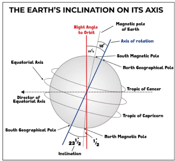
- The linear distance of a degree of latitude at the pole is somewhat longer than that at the equator due to the earth’s minor flattening at the poles.
- Important Parallels of Latitudes:
- Tropic of Cancer (23½° N) in the Northern Hemisphere. It passes through,
- North America: Bahamas (Archipelago), Mexico;
- Africa: Egypt, Libya, Niger, Algeria, Mali, Western Sahara, Mauritania;
- Asia: Taiwan, China, Myanmar, Bangladesh, India, Oman, UAE, Saudi Arabia.
- Tropic of Capricorn (23½° S) in the Southern Hemisphere. It passes through,
- South America: Argentina, Brazil, Chile, Paraguay;
- Africa: Namibia, Botswana, South Africa, Mozambique, Madagascar;
- Australia.
- Arctic Circle at 66 1⁄2° North of the equator.
- Antarctic Circle at 66 1⁄2° in South of the equator.
- Equator: It is the Largest circle, The Equator (0° latitude) at the poles shrinks to a point (90° N &S). The Equator passes through –
- South America: Ecuador, Colombia, Brazil;
- Africa: Sao Tome and Principe, Gabon, Congo, Democratic Republic of Congo, Uganda, Kenya, Somalia;
- Asia: Maldives, Indonesia, Kiribati.
Enroll now for UPSC Online Course
Longitudes (Meridian)
- Definition: The longitude of a place is an angular distance east or west of the Prime Meridian (measured in degrees – 0° to 180°).
- They are semicircles running from the North Pole to the South Pole.
- Each degree is further divided into minutes, and minutes into seconds.
- Prime Meridian: In 1884, it was decided to choose as zero meridian the one which passes through the Royal Astronomical Observatory at Greenwich, near London as a Prime Meridian. It passes through –
- Europe: UK, France, Spain;
- Africa: Algeria, Mali, Burkina Faso, Ghana, Togo;
- Antarctica.
- International Date Line: 180° longitude is chosen as the International Date Line.
- The International Date Line in the mid-Pacific curves from the normal 180° meridian at the Bering Strait, Fiji, Tonga and other islands to prevent confusion of day and date in some of the island groups that are cut through by the meridian.
- Time Perception: A traveller crossing the Date Line from east to west loses a day and while crossing the Date Line from west to east he gains a day.
- The west side of the line is always one day ahead of the Eastern side
- Distance between longitudes decreases steadily from Equator to Poles until it becomes zero at the poles, where all the meridians meet (Maximum at the equator).
- Circle of Illumination: The circle that divides the day from night on the globe is called the circle of illumination. This circle does not coincide with the axis.
Standard Time
- The local time of places which are on different meridians is bound to differ.
- In India, for instance, there will be a difference of about 1 hour and 45 minutes in the local times of Dwarka (Gujarat) and Dibrugarh (Assam).
- In India, the longitude of 82½° E (82° 30’E) is treated as the standard meridian. It passes through Mirzapur, Uttar Pardesh
- It passes through 5 states i.e. Uttar Pradesh, Madhya Pradesh, Chhattisgarh, Odisha, and Andhra Pradesh.
- Indian Standard Time: The local time at this meridian is taken as the standard time for the whole country.
- India located east of Greenwich at 82°30’E is 5 hours and 30 minutes ahead of GMT.
Heat zones of Earth
- Torrid Zone: The mid-day sun is exactly overhead at least once a year on all latitudes in between the Tropic of Cancer and the Tropic of Capricorn. This area, therefore, receives the maximum heat.
- Temperate Zones: Areas between the Tropic of Cancer and the Arctic Circle in the Northern Hemisphere, and the Tropic of Capricorn and the Antarctic Circle in the Southern Hemisphere.
- Frigid Zone: Areas lying between the Arctic Circle and the North Pole in the Northern Hemisphere and the Antarctic Circle and the South Pole in the Southern Hemisphere are called Frigid Zone.
Motion of Earth
- Rotation: Movement of the earth around its axis from west to east.
- Speed of rotation at equators is greater than at poles.
- Effects: Cycle of day & night and Coriolis Force
- Revolution: Movement of the earth around the sun in an elliptical path.
- Distance from the sun is closest on 3rd Jan (Perihelion) and farthest on 4th July (Aphelion).
- Effects: Varying length of day and night and Seasonality, both because of the tilt of the axis.
- Seasons change due to the change in the position of the earth around the sun (Revolution) [UPSC 2013].
- Places beyond the Arctic Circle experience continuous daylight for about six months.
- Solstice: During Solstice, the Sun shines directly over one of the tropics. [UPSC 2022 and 2019]
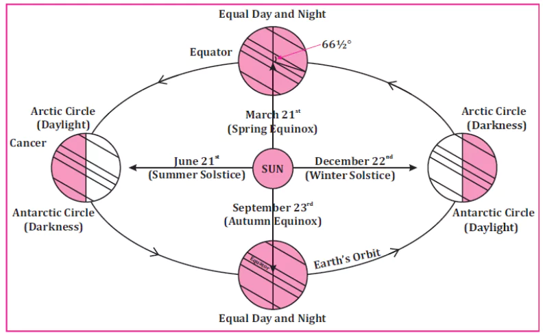
- Summer Solstice: When one of the poles of the Earth has its maximum tilt towards the Sun; Northern Hemisphere – on June 21 and Southern Hemisphere – on December 22; Longest day.
- Winter Solstice: When one of the poles of the Earth has its maximum tilt away from the Sun; Northern Hemisphere— on December 22 and Southern Hemisphere — on June 21; Shortest day.
- Equinox: When the sun shines directly over the Equator, – equal lengths of day and night at all points on Earth; This occurs twice a year.
- 21 March: spring in the northern hemisphere and autumn in the southern hemisphere.
- 23 September: Autumn in the Northern Hemisphere and Spring in the Southern Hemisphere.
Eclipse
- It is defined as an astronomical phenomenon which occurs when one spatial object comes within the shadow of another spatial object.
- It happens when three celestial bodies are in a straight line called syzygy.
Enroll now for UPSC Online Classes
Conclusion
- Latitudes and longitudes together form a grid system that facilitates precise location identification. These coordinates also play a role in determining time zones and understanding Earth’s heat zones and motions, including rotation and revolution.
- Phenomena like solstices, equinoxes, and eclipses are observed and understood about Earth’s axial tilt and orbital path around the sun.
- Overall, latitude and longitude, along with associated concepts, are fundamental to comprehending Earth’s dynamic and complex nature.
 April 26, 2024