Explore Our Affordable Courses

Click Here

India’s Geography: Location, Extent and Borders

May 4, 2024 815 0

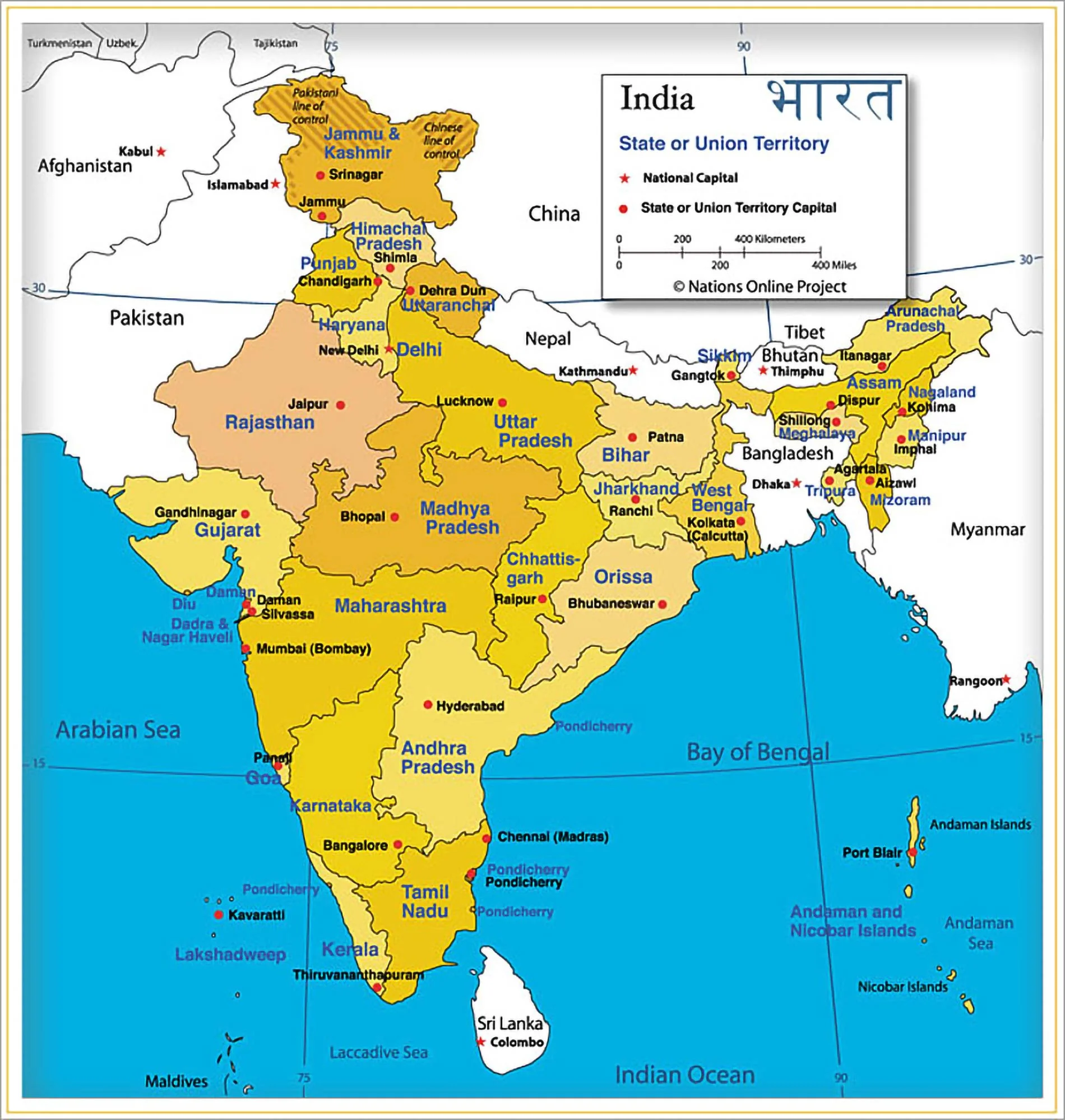
India is a country of vast geographical expanse. It covers an area of 3.28 million sq. km, accounting for 2.4 per cent of the world’s total area. India has the longest coastline among the Indian Ocean littoral countries.

India and its Neighbors

  • Land Borders of India: There are seven countries  that share land boundaries with India namely Pakistan and Afghanistan (Wakhan Corridor) in the Northwest, China, Nepal, and Bhutan in the North and Myanmar and Bangladesh in the East.

Untitled 8

  • The Wakhan Corridor: It is a narrow strip of territory located in Afghanistan. It stretches eastward, connecting Afghanistan to China and also separates Pakistan from Tajikistan.
  • India shares the longest land boundary with Bangladesh followed by China, Pakistan, Nepal, Myanmar, Bhutan and Afghanistan.
  • Island Neighbors : In the Indian Ocean lie our island neighbors – Sri Lanka and Maldives
    • Sri Lanka: is separated from India by Gulf of Mannar and Palk Strait whereas 
    • Maldives Islands: is separated by an 8 degree channel from Lakshadweep Islands.

India’s Geographical Extent: Latitudinal and Longitudinal Dimensions

  • India is located in the northern hemisphere. 
  • Latitudinal Extent: The mainland of India extends between 8°4’N and 37°6’N latitudes from Ladakh to Kanyakumari which is about 3,200 km
  • Longitudinal Extent: It extends between 68°7’E and 97°25’E longitudes from Arunachal Pradesh to Kutch which is about 2,900 km
  • This difference is based on the fact that the distance between two longitudes decreases towards the poles whereas the distance between two latitudes remains the same everywhere.
  • Southernmost Point of the Indian Union: is called Indira point. It is a village in the Great Nicobar district of Andaman and Nicobar Islands. 
    • Six Degree Channel: separates Indira Point from Indonesia.
    • ‘Indira Point’ was submerged under seawater in 2004 during the Tsunami.
  • Indian Mainland: Southernmost point – Kanyakumari; northernmost point – Indira Col (Karakoram Range)
  • Easternmost state: Arunachal Pradesh; 
  • Western most state: Gujarat.[UPSC 2015]
  • The Tropic of Cancer (23°27′ N): passes almost halfway through the country. 
    • The southern part of the country lies within the tropics and the northern part lies in the subtropical zone.
  • Coastline: India has a coastline of 6100 km (mainland) and 7517 km (mainland plus the island groups of Andaman and Nicobar and Lakshadweep).
  • India’s Territorial Limit: further extends towards the sea up to 12 nautical miles (about 21.9 km) from the coast.              
Indian Standard Meridian

  • 82°30’E is the Standard Meridian of India. It is the longitude that determines standard time for the country
  •  It passes through Uttar Pradesh (Mirzapur), Chhattisgarh, Odisha and Andhra Pradesh. Among the capitals of the states mentioned above, Raipur (Chattisgarh) is nearest to ISM.

Tropic of Cancer (23°27′ N)

  • It passes through Gujarat, Rajasthan, Madhya Pradesh, Chhattisgarh, Jharkhand, West Bengal, Tripura, and Mizoram.
  • Maximum length of Tropic of Cancer is in Madhya Pradesh and shortest is in Rajasthan.
  • Mahi River is the only river to cross the Tropic of Cancer twice.
  • Ranchi (Jharkhand) is the closest capital city to the Tropic of Cancer.
  • Capital cities north of Tropic of Cancer: Jaipur (Rajasthan), Agartala (Tripura), Aizawl (Mizoram)
  • Capital cities south of Tropic of Cancer: Gandhinagar (Gujarat), Bhopal (Madhya Pradesh), Raipur (Chattisgarh), Ranchi (Jharkhand), Kolkata (West Bengal), 
Must Read
Current Affairs Editorial Analysis
Upsc Notes  Upsc Blogs 
NCERT Notes  Free Main Answer Writing


Conclusion

  • India’s geography is diverse and extensive, spanning over 3.28 million sq. km. It boasts the longest coastline among Indian Ocean nations. 
  • With land borders shared with seven countries, including Bangladesh, China, and Pakistan, India’s strategic location shapes its diplomatic and geopolitical landscape. \
  • From the northernmost point in the Karakoram Range to the southernmost tip at Kanyakumari, India’s territorial expanse is vast. 
  • The Tropic of Cancer bisects the nation, influencing its climate and positioning several capital cities
Related Articles 
Indian Ocean Rim Association (IORA) LONGITUDE
Indian Geography: Location and Overview Causes of Tsunami

 Final Result – CIVIL SERVICES EXAMINATION, 2023.   Udaan-Prelims Wallah ( Static ) booklets 2024 released both in english and hindi : Download from Here!     Download UPSC Mains 2023 Question Papers PDF  Free Initiative links -1) Download Prahaar 3.0 for Mains Current Affairs PDF both in English and Hindi 2) Daily Main Answer Writing  , 3) Daily Current Affairs , Editorial Analysis and quiz ,  4) PDF Downloads  UPSC Prelims 2023 Trend Analysis cut-off and answer key

THE MOST
LEARNING PLATFORM

Learn From India's Best Faculty


 Final Result – CIVIL SERVICES EXAMINATION, 2023.   Udaan-Prelims Wallah ( Static ) booklets 2024 released both in english and hindi : Download from Here!     Download UPSC Mains 2023 Question Papers PDF  Free Initiative links -1) Download Prahaar 3.0 for Mains Current Affairs PDF both in English and Hindi 2) Daily Main Answer Writing  , 3) Daily Current Affairs , Editorial Analysis and quiz ,  4) PDF Downloads  UPSC Prelims 2023 Trend Analysis cut-off and answer key

Quick Revise Now !
AVAILABLE FOR DOWNLOAD SOON
UDAAN PRELIMS WALLAH
Comprehensive coverage with a concise format
Integration of PYQ within the booklet
Designed as per recent trends of Prelims questions
हिंदी में भी उपलब्ध
Quick Revise Now !
UDAAN PRELIMS WALLAH
Comprehensive coverage with a concise format
Integration of PYQ within the booklet
Designed as per recent trends of Prelims questions
हिंदी में भी उपलब्ध

<div class="new-fform">


    </div>

    Subscribe our Newsletter
    Sign up now for our exclusive newsletter and be the first to know about our latest Initiatives, Quality Content, and much more.
    *Promise! We won't spam you.
    Yes! I want to Subscribe.