
Introduction – Mastering Longitude and the Prime Meridian
Longitude is a fundamental concept in geography and navigation, guiding us along the Earth’s vertical lines. It measures the angular distance, in degrees, east or west of the Prime Meridian (0°). Longitudes play a critical role in determining time zones and coordinating activities across the globe.
Understanding Longitude and the Prime Meridian: Navigating the World Vertically
Longitudes are a fundamental component of the global grid, helping us pinpoint locations east and west of the prime meridian.
- Definition and Measurement: Longitudes are imaginary vertical lines that run from the North Pole to the South Pole.
- They are defined as angular distances, measured in degrees (°), east or west of the prime meridian.
- Meridians: These vertical lines are known as meridians, and collectively, they form a semi-circle around the Earth.
- Unlike latitudes, the length of all meridians is uniform, but the distance between two longitudes diminishes as you move from the equator toward the poles.
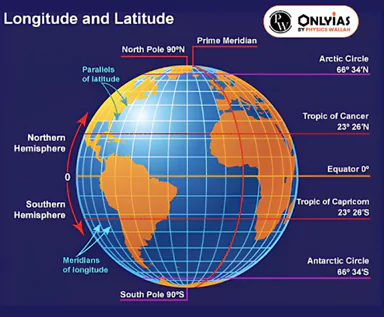
- Convergence at the Poles: All longitudes, or meridians, converge at the Earth’s poles.
- This convergence is a key characteristic of the longitude system.
- Prime Meridian (0°): The prime meridian, located at 0 degrees longitude, serves as the reference meridian for all other longitudes.
- The prime meridian famously passes through Greenwich, a district in London, and is the foundation of the Greenwich Mean Time (GMT).
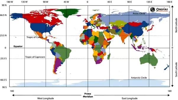
- Total Number of Meridians: Earth is divided into 360 meridians, forming a complete circle around the planet.
- Global Passage of the Prime Meridian: The prime meridian passes through several countries and regions, including the United Kingdom, France, Spain, Algeria, Mali, Burkina Faso, Ghana, and Togo.
- Role in Timekeeping: Longitudes play a pivotal role in determining local time across the globe.
- By dividing the Earth into time zones based on longitudes, longitudes have created a standardized system of timekeeping that helps maintain consistency in global timekeeping practices.
Local Time and Standard Time: Navigating Time Zones
Understanding local time and standard time is essential for synchronizing activities across the globe.
- Greenwich Mean Time (GMT): It is the mean solar time of the prime meridian, which passes through the Royal Greenwich Observatory in England.
- It serves as a reference point for timekeeping.
- Time Adjustment East and West: To maintain synchronized time across the world, countries are divided into time zones based on their distance from the prime meridian.
- Countries to the east of the prime meridian gain time, often referred to as “East – Gain – Add.”
- Conversely, countries to the west of the prime meridian lose time, known as “West – Lose – Subtract.”
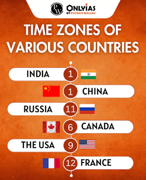
- Time Equivalence: The Earth is divided into 360 degrees of longitude, and there are 24 hours in a day.
- Using this relationship, 1 degree of longitude is equivalent to 4 minutes of time.
- This means that with every 1-degree movement east or west of the prime meridian, time increases or decreases by 4 minutes.
- Practical Application: As you move eastward across time zones, you add time to your clock because you are moving ahead of the prime meridian.
- Conversely, when moving westward across time zones, you subtract time from your clock since you are lagging behind the prime meridian.
- This system of time zones helps keep activities and schedules coordinated across regions.
| Parameters | Local Time | Standard Time |
| Meaning |
|
|
| Variations |
|
|
| Longitude |
|
|
| Reckoned by |
|
|
International Date Line (IDL): Navigating Time and Date Changes
The International Date Line (IDL) is a crucial component of global timekeeping, and it plays a significant role in managing dates and times across the world.
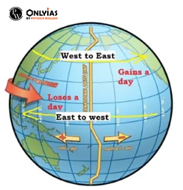
- Location: The IDL is positioned at the 180° longitude, precisely halfway around the Earth from the Prime Meridian (0°).
- While it theoretically passes through the mid-Pacific Ocean, it follows a zigzag path at certain points to avoid confusion and simplify date changes.
- Zigzag at Key Points: The IDL notably zigzags near significant landmasses and islands, such as the Bering Strait between Siberia and Alaska, as well as islands like Fiji and Tonga.
- This zigzagging ensures that regions on opposite sides of the line maintain consistent date and time arrangements.
- Date Change: Crossing the International Date Line results in an immediate change of date by one day.
- For example, when moving from west to east across the IDL, you advance to the next day, and when moving from east to west, you move back one day.
Indian Standard Time (IST)
Indian Standard Time (IST) is the time zone observed throughout India.
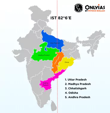
- IST is based on the 82°30’E meridian, which is 5.30 hours ahead of Greenwich Mean Time (GMT).
- This means that when it’s 12 midnight at the Prime Meridian (GMT), it’s 5.30 AM in India.
- Standard Meridian: The standard meridian for India, which aligns with IST, passes through Mirzapur in Uttar Pradesh.
- It extends across the Indian states of Madhya Pradesh, Chhattisgarh, Odisha, and Andhra Pradesh, providing a unified time standard for the country.
Do You Know?
|
India’s Need for Two Time Zones: A Debate – The Quest for Synchronizing a Vast Nation, Prime Meridian Included
The topic of whether India should adopt two time zones has sparked a debate, with proponents and opponents presenting compelling arguments:
Arguments in Favor of Two Time Zones:
- Geographical Extent: India’s vast geographical extent, ranging from Gujarat in the west (68°7’ E) to Arunachal Pradesh in the east (97°25’ E), spans a longitudinal extent of 30°.
- This wide expanse supports the need for two time zones to better align with daylight hours.
- Productivity Loss: Northeastern states often experience early sunrise, as early as 4 am, while offices open later, around 10 am.
- This misalignment results in a loss of productive daylight hours and hampers efficiency.
- Biological Clock: Synchronizing the biological clock with the day-night cycle is essential for maintaining overall well-being.
- A single time zone disrupts the circadian rhythm, affecting the health and productivity of individuals.
Arguments Against Two Time Zones:
- Mismatch and Railway Safety: Implementing two time zones could lead to a mismatch in office timings and potentially result in more railway accidents due to confusion about schedules.
- Mass Confusion: With a significant portion of the population having varying levels of literacy, introducing two time zones might create chaos and confusion among the masses, especially in rural areas.
- Boundary Marking Challenge: Determining the exact dividing line between the two time zones is a challenging task.
- Defining and marking such boundaries could pose logistical difficulties.
- Regionalism and National Unity: The introduction of two time zones may inadvertently promote regionalism and affect the unity and integrity of India, as it would create disparities in timekeeping across the country.
Alternative Solutions:
- Daylight Saving Time: Instead of two time zones, India could consider implementing daylight saving time in specific regions to optimize daylight hours and enhance productivity.
- Stakeholder Consultation: Any decision regarding time zones should be made after consulting with all stakeholders, including state governments and the public.
- Factors like circadian rhythm, individual biological cycles, and day and night timings should be considered in the decision-making process.
| Previous Year Question (Prelims)
Q. On 21st June, the Sun________________________(2019)
Ans: a Q. In the Northern Hemisphere, the longest day of the year normally occurs in the: (2022)
Ans: b |


