A World Carved by Nature: Groundwater, Waves, Winds, and Glaciers in Geology
Introduction: Beyond Running Water
In Part 1, we delved into the significance of Running Water in shaping the evolution of landscapes. In this article, we will extend our exploration by examining how other forces, such as Groundwater, Waves & Currents, and Winds, and Glaciers, contribute to this process.
Groundwater: Shaping the Landscape
Groundwater, in conjunction with glaciers, plays a crucial role in the erosion of landmasses and the evolution of landforms, particularly in areas with certain types of rock, such as limestone and dolomite. The processes through which groundwater influences the landscape:
-
- Percolation in Permeable Rocks: Surface water, as well as groundwater, percolates efficiently in rocks that are permeable, thinly bedded, and highly jointed or cracked.
- Permeable rocks, including those shaped by glaciers, allow water to penetrate and move through them more easily.
- Vertical and Horizontal Movement: After entering the ground, water, influenced by glaciers and other forces, moves both vertically and horizontally.
- It flows horizontally through bedding planes, joints, or the materials themselves.
- Erosion through Solution and Deposition: Groundwater, particularly in rocks like limestones and dolomites rich in calcium carbonate, contributes to erosion through chemical processes.
- Solution and precipitation deposition, influenced by glaciers, are the two primary mechanisms involved in the development of various landforms in such rock types.
- Karst Topography: Regions where limestone or dolomite rocks display distinctive landforms created by the action of groundwater through the processes of solution and deposition are referred to as Karst topography.
- This term originates from the Karst region in the Balkans, which is adjacent to the Adriatic Sea and is known for its limestone topography.
- Percolation in Permeable Rocks: Surface water, as well as groundwater, percolates efficiently in rocks that are permeable, thinly bedded, and highly jointed or cracked.
- Karst topography is characterized by a variety of erosional and depositional landforms, influenced by glaciers and other geomorphic agents.
-
-
- These may include sinkholes, caves, underground rivers, stalactites, stalagmites, and other features formed through the dissolution of calcium carbonate in the rock and subsequent deposition.
-
Erosional Landforms – Pools, Sinkholes, Lapies, and Limestone Pavements
-
- In limestone terrain, shallow depressions known as swallow holes often emerge on the surface due to the dissolution process.
- Sinkholes: These are a frequent occurrence in limestone or karst regions.
- These sinkholes typically have a circular or funnel-shaped opening, with dimensions ranging from a few square meters to a hectare and depths varying from less than half a meter to over thirty meters.
- Some of these sinkholes form exclusively through the dissolution process, referred to as solution sinks.
- While others initially take shape through solution and may later collapse, creating an opening into an underground cave or void below, known as collapse sinks (doline).
- These sinkholes are sometimes covered by a layer of soil, resembling shallow water pools, and can be treacherous, causing anyone stepping on them to sink, similar to quicksand in deserts.
- Solution sinks are more common than collapse sinks.
- Surface runoff often flows into swallow and sinkholes, traveling as underground streams before reemerging downstream through cave openings.
- When sinkholes and dolines merge due to material slumping along their edges or roof collapses within caves, they can create long, narrow to wide trenches known as valley sinks or uvalas.
- Lapies: Over time, these pits and trenches erode the limestone’s surface, leaving behind a highly irregular landscape with a complex network of points, grooves, and ridges known as lapies.
- These ridges or lapies are formed primarily due to differential dissolution along joints that run parallel or sub-parallel to each other.
- Eventually, the lapie field may transform into relatively smooth limestone pavements.
- These ridges or lapies are formed primarily due to differential dissolution along joints that run parallel or sub-parallel to each other.
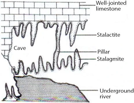
Caves: Geological Wonders and Glaciers Influences
- Cave formation is a prominent geological phenomenon in regions characterized by alternating rock beds, such as shales, sandstones, and quartzites, interspersed with limestones or dolomites.
- In areas where limestones exhibit high density and thickness in the form of substantial beds, the development of caves is particularly notable.
- The process of cave formation is initiated as water infiltrates downward, either permeating through the geological materials or seeping through cracks and joints in the rock layers.
- This water then moves horizontally along the bedding planes, which play a crucial role in the dissolution of the limestone.
- The outcome of this dissolution is the creation of elongated to wide gaps in the rock structure, commonly referred to as caves.
- Depending on the specific limestone beds and the presence of intervening rock layers, a network of caves may exist at various elevations.
- It’s important to note that caves typically feature an entrance or opening through which cave streams are discharged.
- In instances where caves have openings at both ends, they are referred to as tunnels.

Depositional Landforms – Stalactites, Stalagmites, and Pillars
-
- Stalactites dangle like variously sized icicles, typically featuring wider bases that gradually taper towards their free-hanging tips, showcasing a diverse array of shapes.
- Stalagmites, on the other hand, ascend from the cave floor.
- They form as a result of water dripping from the cave surface or through the slender tube-like structure of the stalactite just below it.
- Stalagmites can assume the form of columns, discs with either smooth, rounded, bulging ends, or miniature crater-like depressions.
- Over time, stalagmites and stalactites merge, giving rise to columns and pillars of varying diameters.
Glaciers – Landscape Transformation
Glaciers, whether expansive sheets (continental or piedmont) or flowing mountain glaciers, move slowly due to gravity. They erode through the friction of their massive ice weight, plucking and dragging material, reshaping landscapes. Over time, they level terrain, leaving behind low hills, outwash plains, and other features.
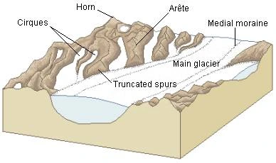
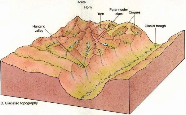
Erosional Landforms – Cirques, Horns, Serrated Ridges, and U-shaped Valleys
Cirque: Glaciers Sculptures in Mountain Peaks
- Cirques, frequently encountered in glaciated mountain regions, typically occupy the upper reaches of glacial valleys.
- These distinctive features are sculpted by the relentless advance of ice from the mountain peaks.
- Cirques manifest as deep, extensive troughs or basins with steeply concave to nearly vertical walls at their heads and sides.
- Subsequently, once the glacier retreats, it is not uncommon to find tranquil lakes within these cirques.
- These bodies of water are often referred to as cirque or tarn lakes.
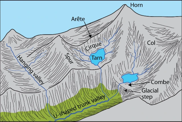
Horns and Serrated Ridges: Glaciers Artistry in Mountain Peaks
- Horns take shape as a result of the erosion that occurs at the upper regions of cirque walls.
-
- When three or more glaciers radiate outward, cutting their way headward until their cirques converge, they give rise to the creation of lofty, sharply pointed, and steeply inclined peaks known as Horns.
- The partitions between the sides of cirque walls, also called headwalls, gradually narrow due to ongoing erosion, leading to the development of Serrated or saw-toothed ridges.
- These ridges are sometimes referred to as Arêtes, characterized by their extremely sharp crests and a distinctive zig-zag appearance.
Glacial Valleys/Troughs: U-shaped Wonders Carved by Ice
- Glacial valleys exhibit a distinctive U-shaped configuration, characterized by their broad, smooth floors and steep sides.
- These valleys can often be strewn with scattered debris, including moraine-shaped formations that give them a somewhat swampy appearance.
- It is not uncommon to find lakes either carved into the rocky valley floor or formed by debris accumulation within these valleys.
- Hanging valleys: They are positioned at varying elevations on one or both sides of the primary glacial valley, can be observed.
- The connecting faces of divides or spurs from these hanging valleys, as they merge with the main glacial valley, often possess a distinctive truncated appearance, resembling triangular facets.
- Fiords: In high-latitude regions, exceptionally deep glacial troughs, which are inundated with seawater and shape coastlines, are referred to as fjords or fiords.
Depositional Landforms – Moraines, Eskers, Outwash Plains, and Drumlins
When glaciers melt, they leave behind unsorted debris called glacial till, characterized by angular rock fragments. Melting ice creates streams, carrying smaller rock debris that gets deposited as outwash deposits. Unlike till, outwash deposits are stratified and contain more rounded rock fragments.
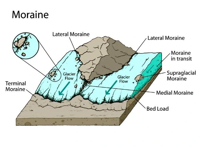
Moraines: Exploring the Landscape of Debris and Till
-
- Moraines are extended formations composed of glacial till deposits.
- Terminal moraines, in particular, are lengthy accumulations of debris that gather at the extremities (or toes) of glaciers.
- Lateral moraines take shape alongside glacial valleys, running parallel to them.
- In some cases, these lateral moraines may converge with a terminal moraine, creating a horseshoe-shaped ridge.
- Glaciofluvial waters, pushing materials to the sides of glaciers, are responsible for the formation of many of these moraines, either partially or entirely.
- Ground Moraines: When valley glaciers undergo rapid retreat, they leave behind irregular layers of till across their valley floors.
- These deposits, which vary significantly in thickness and surface features, are referred to as ground moraines.
- Medial Moraine: Positioned in the center of a glacial valley and flanked by lateral moraines is the medial moraine.
-
- In comparison to lateral moraines, medial moraines are somewhat less well-defined.
- At times, medial moraines may be challenging to distinguish from ground moraines.
Eskers: Deciphering the Origins of Eskers
- Eskers are the result of a specific geological process.
- When glaciers start to melt during the summer, the water generated can take several paths.
- Water may travel on the surface of the ice, seep down along the glacier’s edges, or even find its way through openings in the ice.
- These water streams eventually accumulate beneath the glacier and flow as if they were rivers within an ice channel.
- Remarkably, these streams do not follow traditional valleys in the terrain but flow directly over the ground, with ice acting as natural embankments.
- As these water channels beneath the glacier carry sediment, including large boulders, blocks, and smaller fragments of rock debris, these materials settle within the ice valley.
- When the ice subsequently melts, it unveils a winding, sinuous ridge known as an esker.
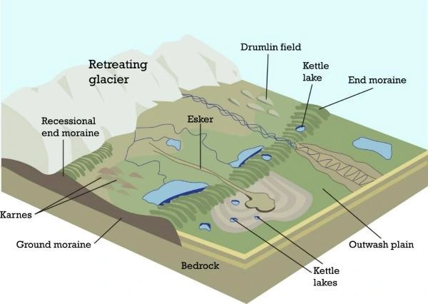
Outwash Plains: Exploring the Allure of Outwash Plains
- Outwash Plains, also known as glacio-fluvial plains, can be found at the bases of glacial mountains or extending beyond the boundaries of continental ice sheets.
- These expanses are blanketed with wide, level alluvial fans formed by the deposition of gravel, silt, sand, and clay, which may merge to create extensive outwash plains.
Drumlins: The Enigmatic Beauty of Drumlins
- Drumlins are gently rounded, elliptical landforms primarily consisting of glacial debris, including significant deposits of gravel and sand.
- These formations have their elongated axes aligned in the direction of ice flow and can reach lengths of up to 1 kilometre, with heights reaching approximately 30 metres.
- One end of a drumlin, known as the stoss end, is characterized by a more rounded and steeper profile,
- While the other end, referred to as the tail, is relatively more tapered.
- Drumlins are the result of the accumulation of rock fragments beneath heavily laden ice, which occurs through openings or crevices within the glacier.
- The stoss end undergoes a process of blunting due to the pressure exerted by the moving ice.
- These distinctive features also serve as indicators of the direction of glacier movement.
Waves And Currents: Coastal Dynamics
Coastal processes are inherently dynamic and often pose significant threats. Therefore, it is imperative to acquire knowledge about these coastal phenomena and their resultant formations. Several alterations along coastlines occur rapidly, with erosion happening in one season and deposition in another at the same location. The primary catalyst for most of these coastal changes is the action of waves.
When waves crash, they forcefully propel water onto the shore while simultaneously stirring up sediments on the seabed. The continuous impact of breaking waves exerts a profound influence on coastal landscapes.
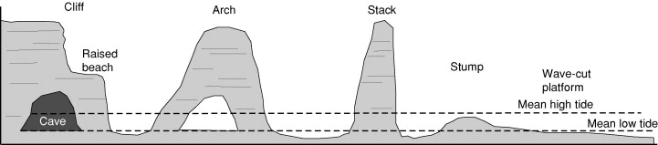
Erosional Landforms – Cliffs, Terraces, Caves and Stacks
- Wave-cut cliffs and terraces are typically observed in regions where erosion is the predominant coastal process.
- Sea cliffs are generally steep, ranging from a few meters to as much as 30 meters or even more in height.
- At the base of these cliffs, there often exists a flat or gently sloping platform covered with rock fragments originating from the cliff itself.
- These platforms, located above the typical wave height, are referred to as wave-cut terraces.
- The relentless assault of waves against the cliff’s base, combined with the impact of rock debris carried by the waves, results in the creation of hollows.
- These hollows gradually widen and deepen, ultimately forming sea caves.
- Over time, the cave roofs may collapse, causing the sea cliffs to recede further inland.
- As the cliffs recede, isolated remnants of rock may be left standing just off the shore, which are known as sea stacks.
- These sea stacks, initially part of a larger cliff or hill, are relatively resistant to erosion.
- It’s important to note that sea stacks, like all other coastal features, are also temporary, and eventually, coastal hills and cliffs will succumb to wave erosion.
- This erosion will lead to the formation of narrow coastal plains, and with the accumulation of land-based deposits, these areas may become covered with alluvium, shingle, or sand, forming expansive beaches.
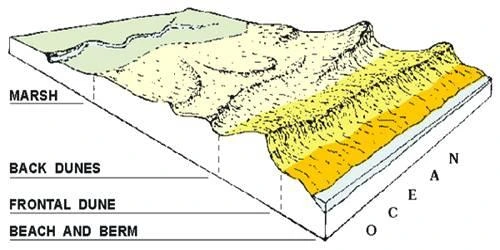
Depositional Landforms – Beaches and Dunes
- Beaches are indicative of coastlines primarily characterized by the deposition of sediments, but they can also appear sporadically along rugged shores.
- The majority of the materials constituting these beaches are sourced from the land via transportation by streams and rivers or through erosion caused by waves.
- A sandy beach, which may appear permanent, can dwindle to a narrow strip of coarse pebbles during different seasons.
- Most beaches consist of sand-sized particles.
- There are instances of “shingle beaches” containing even smaller pebbles and occasionally cobbles.
- Sand dunes, which form elongated ridges parallel to the coastline, are a common sight along low-lying sedimentary coastlines.
Winds: Desert Wind Erosion
Wind and the scorching desert sun are the dominant forces in hot deserts. Dry, barren desert floors heat up quickly, causing the air above them to rise, creating turbulence and various phenomena like eddies and whirlwinds. Fast desert winds, including destructive storm winds, can cause deflation, abrasion, and impact on rocks.
Rainfall, although scarce, can be torrential and occurs in short bursts. This rain, along with wind, contributes to erosion. Wind moves fine materials, while rain, in the form of sheet floods, is the primary agent of mass erosion in desert landscapes. Stream channels in deserts are broad and temporary, flowing briefly after rain.
Erosional Landforms – Pediments and Pediplains
Pediments: The Origins of Pediments
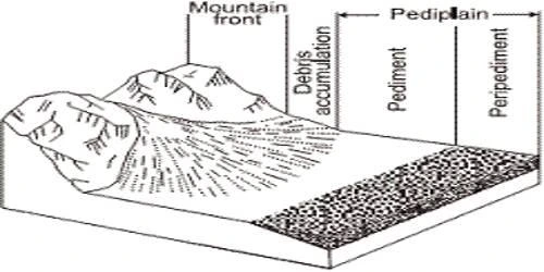
- Pediments refer to gently sloping rocky surfaces located near the base of mountains, which may or may not be covered by a thin layer of debris.
- These rocky surfaces are shaped through a process involving the erosion of the mountain front, driven by a combination of lateral erosion by streams and sheet flooding.
- Once pediments take shape, characterized by a steep wash slope followed by a cliff or exposed face above it, the steep wash slope and the exposed face begin to recede.
- This erosion method is known as the parallel retreat of slopes through backwasting.
- Consequently, through the parallel retreat of slopes, pediments gradually extend backward at the cost of the mountain front.
- Over time, the mountain diminishes in size, eventually leaving behind an inselberg, which serves as a remnant of the original mountain.
- This process is responsible for transforming high relief desert areas into low, featureless plains known as pediplains.
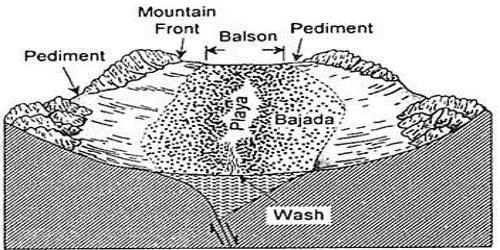
Playas: Exploring the Beauty of Playas in Desert Regions
- Playas, within desert regions, stand out as the most dominant landforms.
- In basins encompassed by mountains and hills, the natural flow of water is directed toward the center of the basin, leading to the gradual accumulation of sediment at the basin’s edges, resulting in the formation of a nearly level plain in the basin’s core.
- During times of ample water supply, this plain may be submerged by a shallow body of water.
- Such shallow lakes are commonly referred to as playas, where the water is retained for brief periods due to evaporation, often resulting in a significant accumulation of salts within the playas.
- When a playa plain becomes covered with salt deposits, it is designated as alkali flats.
Deflation Hollows and Caves: The Genesis of Deflation Hollows and Caves
- When relentless wind currents sweep across the exposed rock or bare soil, they erode the weathered surface, leading to the creation of shallow depressions known as deflation hollows.
- Additionally, this ongoing process results in the formation of small pits and cavities on the rock surfaces as they endure the impact and abrasion of wind-borne sand.
- Initially, these depressions are superficial, referred to as “blow outs,” but over time, some of them evolve into deeper and wider formations that can be rightfully called caves.
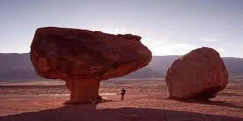
Mushroom, Table, and Pedestal Rocks: Glaciers Persistence
- In desert environments, numerous rock outcrops are particularly susceptible to the forces of wind deflation and abrasion, causing rapid erosion.
- However, amid this wear and tear, certain resilient rocks manage to retain their form and become strikingly polished.
- These enduring rock formations take on distinct shapes, resembling mushrooms with slender stems and broad, rounded caps.
- In some instances, the top surface of these rocks becomes flat like a table, and quite frequently, the remnants stand tall, resembling pedestals.
Depositional Landforms – Exploring the Diversity of Sand Dunes in Deserts
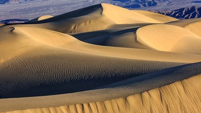
Sand Dunes: The Dynamic World of Desert Sand Dunes
- Sand dunes thrive in dry, hot deserts, with various forms emerging based on specific conditions.
- Barchans: Crescent-shaped dunes, formed in areas with constant and moderate wind.
- Parabolic dunes reverse this shape when vegetation covers sandy surfaces.
- Seif Dunes: These resemble barchans but have a single wing, indicating wind direction shifts.
- Longitudinal Dunes: These dunes appear in sand-poor, wind-steady settings, creating lengthy, low ridges.
- Transverse Dunes: At right angles to the wind, arise when sand sources align.
- In areas with abundant sand, dunes often coalesce, losing distinct shapes.
- Most desert dunes are in motion, stabilizing only near human habitation.