
Introduction: The Evolution of Landforms through Geomorphic Forces
The Earth’s surface is a dynamic and ever-changing canvas, shaped by the forces of nature over millions of years. Landforms, such as mountains, valleys, plateaus, and plains, have evolved through a complex interplay of geological, climatic, and environmental factors.
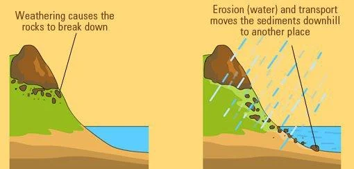
Once weathering processes have exerted their influence on the earth’s surface materials, various geomorphic agents, such as running water, groundwater, wind, glaciers, and waves, engage in the process of erosion, shaping different landforms. Erosion, in turn, instigates alterations to the earth’s surface. Subsequently, deposition takes place, and changes in landforms on the earth’s surface also occur because of this deposition.
Processes and Agents Responsible for Evolution of Landforms: Shaping the Earth
- Erosion and Deposition: The Earth’s surface, including various landforms, is constantly changing due to the actions of erosion and deposition.
- Erosion involves the removal of materials from the land surface, while deposition involves the addition of materials to it.
- These processes can lead to significant alterations in the landscape.
- Sequence of Erosion and Deposition: Erosion typically precedes deposition.
- As agents erode the land, they transport the eroded material to other areas where it can be deposited.
- This sequence of events contributes to the reshaping of the land.
- Erosional and Depositional Agents: The passage mentions several geomorphic agents responsible for these processes, shaping diverse landforms:
- Running Water: Rivers and streams can erode and carry sediment, shaping valleys and floodplains.
- They also deposit sediments in deltas and other areas.
- Groundwater: Underground water movement can dissolve and transport minerals, leading to processes like cave formation.
- Glaciers: Ice sheets erode land and leave behind distinctive glacial landforms, including moraines and U-shaped valleys.
- Wind: Wind can erode and transport fine particles, contributing to features like sand dunes.
- Waves: Ocean waves can erode coastlines and deposit sediments along shorelines.
- Running Water: Rivers and streams can erode and carry sediment, shaping valleys and floodplains.
- Weathering and Mass Wasting: In addition to erosion and deposition, weathering (the breakdown of rocks into smaller particles) and mass wasting (the downslope movement of materials) play significant roles in shaping the Earth’s surface.
- Sequential Development of Landforms: Over long periods of time, the combined actions of these geomorphic agents lead to systematic changes in the landscape.
- The processes can result in the sequential development of various landforms, such as mountains, valleys, plains, and coastal features.
Difference between Weathering and Erosion:
|
Running Water: Landscape Transformation
In regions with heavy rainfall and high humidity, running water is a significant geomorphic agent, meaning it plays a crucial role in shaping the landscape. Running water is divided into two main components:
- Overland Flow: This refers to the movement of water across the general land surface as a sheet.
- It typically occurs during heavy rainfall and contributes to erosion and sediment transport.
- Linear Flow: This component involves the flow of water as streams and rivers within valleys.
- Rivers play a major role in shaping the landscape.
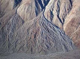
Overland Flow and Sheet Erosion: Overland flow, which occurs due to rainfall and other factors, causes sheet erosion, influencing the formation of various landforms. It results in the removal of materials from the surface of the land and their transportation in the direction of flow.
-
- Formation of Rills: Over time, due to the friction of flowing water, small and narrow channels known as rills begin to form. These rills are the early stages of erosional features on the landscape.
- Development into Gullies: Rills can gradually develop into larger and wider channels known as gullies. These gullies deepen, widen, lengthen, and may eventually unite to form a network of valleys.
- Stages of Landscape Evolution:
- Early Stages: During this phase, the focus is on downcutting, where irregularities in the landscape, such as waterfalls and cascades, are gradually eroded and removed.
- Middle Stages: In the middle stages of landscape development, streams cut their beds at a slower rate, and lateral erosion of valley sides becomes more pronounced. The valley sides are gradually reduced to lower slopes.
- Formation of a Peneplain: As erosion continues, the divides between drainage basins are lowered, and the landscape is transformed into a lowland with faint relief.
- Some low-resistant remnants, often referred to as “monadnocks,” may remain as isolated features in the otherwise flattened lowland.
- This type of plain forming as a result of stream erosion is called a “peneplain,” which means “almost plain.”
Work of River (Linear Flow): Shaping Landforms from Youth to Maturity
Rivers play a significant role in the evolution of landforms through a process known as fluvial geomorphology. This process involves the shaping of the Earth’s surface by the erosional and depositional actions of flowing water.
There are three main stages in the life cycle of a river. Each stage is characterized by distinct landforms and processes.
- Youthful Stage: Carving V-Shaped Landscapes
- In the youthful stage, the river is typically found in a mountainous or hilly region.
- It has a steep gradient, meaning it flows quickly and erodes the landscape rapidly.
- Erosion is the dominant process in this stage, and the river forms V-shaped valleys through the process of downward cutting.
- Landforms in this stage include narrow canyons, waterfalls, and rapids.
- The river channel is often narrow, and there is little sediment deposition.
- Mature Stage: The Art of Meandering
- As the river progresses downstream, it enters the mature stage.
- In this stage, the river’s gradient becomes less steep, and it starts to meander or wind more as it erodes the sides of the valley.
- Erosion and deposition are more balanced, and the river begins to widen its valley.
- The landforms associated with the mature stage include meanders, floodplains, and oxbow lakes.
- Sediment deposition becomes more significant in the riverbed and on the floodplain.
- Old Stage: Mountains to the Coast
- In the old stage, the river has a very gentle gradient, and it flows through relatively flat terrain, often near the coast.
- Erosion is minimal, and deposition becomes the dominant process.
- The river’s channel is broad, and it may have several distributaries, creating a delta near the coast.
- Landforms include large floodplains, deltas, and distributaries.
- The river is generally characterized by its slow and meandering flow in this stage.
Erosional Landforms – Valleys, Potholes, Plunge Pools, and River Terraces
Valleys: The Diverse World of Geological Landforms
-
- Valleys originate from modest and narrow channels known as rills, which gradually evolve into extensive and broad gullies.
- These gullies then continue to deepen, widen, and elongate, eventually forming valleys.
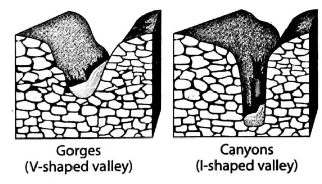
- Depending on their size and configuration, various valley types can be identified, including V-shaped valleys, gorges, canyons, and more.
-
- A gorge is characterized by its profound depth and steep to nearly vertical sides while a canyon exhibits steep, terrace-like side slopes and can be as deep as a gorge.
- Gorges typically maintain a consistent width from top to bottom, while canyons are wider at their upper reaches than at the base.
- It’s worth noting that canyons can be considered a subtype of gorge.
- The specific type of valley that forms depends on the geological composition and structure of the rocks in the area.
- For instance, canyons tend to develop in horizontally layered sedimentary rocks, whereas gorges are commonly associated with rugged, hard rock formations.
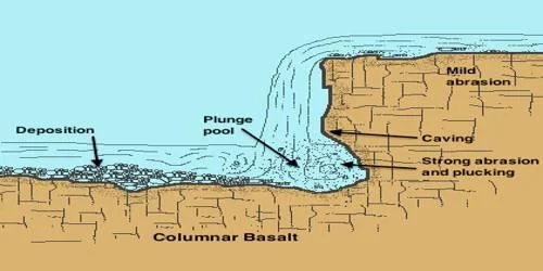
Potholes and Plunge Pools in Hill Streams: Sculpting Landforms in Hill Streams
- Circular depressions, known as potholes, emerge on the rocky beds of hill-streams due to the combined action of stream erosion and the abrasive effect of rock fragments.
- These potholes start as small, shallow indentations but gradually expand in size as pebbles and boulders accumulate within them.
- Flowing water causes these embedded rocks to rotate, further contributing to the enlargement of these depressions.
- Over time, a series of such depressions may merge, deepening the entire stream valley.
- Additionally, at the base of waterfalls, large and wide potholes, often quite deep, are formed due to the intense force of water and the rotation of boulders.
- These significant depressions at the waterfall’s base are referred to as plunge pools.
- These plunge pools play a crucial role in the process of valley deepening.
- It’s important to note that waterfalls, like other landforms, are temporary and will gradually recede, ultimately bringing the valley floor above the waterfall down to the level below.
Terraces Along Rivers: Erosional Landforms and Geological Signposts
-
- River terraces are elevated surfaces that serve as markers for previous levels of river valleys or floodplains.
- These terraces can take the form of exposed bedrock surfaces or be composed of sediment deposits from the river.
- River terraces primarily originate from erosional processes, which occur as the river vertically erodes its own floodplain.
- These terraces can exist at various elevations, signifying former riverbed levels.
- When terraces of the same height are found on both sides of a river, they are referred to as “paired terraces.”
-
- In contrast, when a terrace is present on one side of the river but absent or at a significantly different elevation on the opposite side, they are known as “unpaired terraces.”
- Unpaired terraces are commonly observed in regions characterized by slow land uplift or where there are variations in water level changes along the riverbanks.
- In contrast, when a terrace is present on one side of the river but absent or at a significantly different elevation on the opposite side, they are known as “unpaired terraces.”
- The formation of these terraces can be attributed to several factors, including the receding of water after a peak flow event, alterations in hydrological patterns due to changes in climate, tectonic land uplift, and fluctuations in sea levels for rivers in proximity to the coast.
Depositional Landforms – Exploring Erosional Landforms in Rivers
Alluvial Fans – Nature’s Dynamic Landforms
-
- Alluvial fans take shape when streams originating from elevated areas diverge onto the gently sloping plains below.
- Typically, these streams bear a significant load of coarse materials as they flow down mountain slopes.
- However, as the gradient becomes less steep, these streams find it increasingly challenging to transport this heavy load.
- It causes the materials to be deposited and distributed as a wide, cone-shaped formation known as an alluvial fan.
- It’s worth noting that these streams often don’t remain fixed in their original channels for extended periods and tend to shift across the fan’s expanse.
- It creates numerous smaller channels referred to as distributaries.
- In regions with high levels of moisture, alluvial fans typically exhibit broad, low-cone shapes with gradual slopes from top to bottom.
- While in arid and semi-arid climates, they tend to take on the form of high cones with steeper inclines.
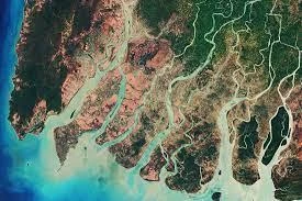
Deltas: Coastal Marvels and Unique Landforms
-
- Deltas can be likened to alluvial fans, but they form in different geographic locations.
- Rivers transport sediment and deposit it into the sea, where, if it is not carried far into the sea or distributed along the coast, it accumulates and forms a broad, low cone-shaped landmass.
- Unlike alluvial fans, the sediment deposits in deltas exhibit a high degree of sorting, with clear layers of different sediment types.
- The heaviest materials settle out first.
- While the finer particles, such as silts and clays, are carried further out into the sea.
- As the delta expands, the river’s distributaries, or branching channels, grow longer, contributing to the ongoing expansion of the delta into the sea.
River Landforms: Floodplains, Natural Levees, and Point Bars
-
- A floodplain represents a significant landform created by the deposition of materials in a river’s course.
- Typically, when a stream channel transitions to a gentler slope, it begins to deposit larger-sized materials first.
- Consequently, finer materials like sand, silt, and clay are transported by slower-moving waters in the gentler channels often found on plains.
- These materials are deposited either on the riverbed or, during flooding, overflow onto the banks above the riverbed.
- A floodplain represents a significant landform created by the deposition of materials in a river’s course.
- The active floodplain is thus constituted by the river deposits, while the inactive floodplain above the banks contains two distinct deposit types: flood deposits and channel deposits.
-
- In plain regions, river channels have a tendency to shift laterally and occasionally alter their courses, leaving behind abandoned or cut-off courses that gradually accumulate coarse deposits.
- The flood deposits, which result from water overflowing the banks, typically carry finer materials such as silt and clay.
- In delta regions, floodplains are referred to as delta plains.
- Two significant landforms associated with floodplains are natural levees and point bars.
- Natural Levees: These are commonly found along the banks of large rivers, appearing as low, linear ridges of coarse deposits. These ridges are often cut into individual mounds.
- During flooding, as water spills over the riverbank, its velocity decreases, causing the deposition of large-sized, high-density materials in the immediate vicinity of the bank in the form of ridges.
- Natural levees are higher closer to the riverbanks and slope gently away from the river.
- The materials deposited on levees are coarser than those spread by floodwaters away from the river.
- When rivers undergo lateral shifts, a series of natural levees can develop.
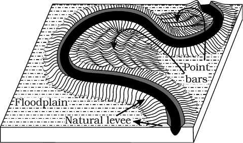
- Point Bars: These are also known as meander bars, and are situated on the convex side of meanders in large rivers.
- They consist of sediments deposited linearly by flowing water along the riverbank.
- Point bars typically have a uniform profile and width, and they contain a mixture of sediment sizes.
- If there are multiple ridges, narrow and elongated depressions are found in between these point bars.
- Rivers construct a series of point bars based on water flow and sediment supply.
- As rivers build point bars on the convex side, the concave side of the bank experiences active erosion.
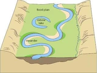
Meanders: Exploring River Channel Patterns and Landforms
- In extensive floodplains and delta regions, rivers seldom follow straight courses. Instead, they tend to form loop-like channel patterns known as meanders.
- It’s important to note that a meander is not a distinct landform but rather a specific type of channel pattern. This occurs due to several factors:
- The gentle slopes encourage water to erode the banks laterally.
- The banks are composed of unconsolidated alluvial deposits with various irregularities that the flowing water can utilize, exerting lateral pressure.
- The Coriolis force acts on the fluid water, causing it to deflect in a manner similar to how it affects the wind.
- As the channel’s slope becomes extremely gentle, the water flows slowly and begins to erode the banks laterally.
- Minor irregularities along the banks gradually evolve into small curvatures in the banks.
- These curvatures become more pronounced due to the deposition of sediments on the inside of the curve and erosion along the outer bank.
- The tendency for meandering is diminished when there is neither deposition nor erosion or undercutting.
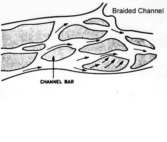
Braided Channels: Exploring the Complex Landforms of Rivers
- When rivers transport coarse materials, they may undergo selective deposition of the coarser sediments, resulting in the creation of a central bar that diverts the flow towards the riverbanks.
- This diversion of flow contributes to increased lateral erosion along the banks.
- As the valley widens, the volume of water decreases, leading to the accumulation of more materials in the form of islands and lateral bars.
- This process gives rise to multiple separate channels of water flow.
- The interplay of deposition and lateral erosion along the banks is fundamental to the formation of the characteristic braided pattern.
- Alternatively, when the river’s discharge is reduced while the sediment load remains high in the valley, bars and islands composed of sand, gravel, and pebbles emerge on the channel floor.
- This causes the water flow to split into numerous thread-like streams.
- These thread-like streams repeatedly merge and divide, ultimately creating the distinctive braided pattern.
| Previous Year Questions asked by UPSC:
Q. Define mantle plume and explain its role in plate tectonics. (2018) Q. There is no formation of deltas by rivers of the Western Ghat. Why? (2013) |


