Earthquake Zones: Understanding the Global and Indian Seismic Landscape
Earthquakes are natural disasters that result from the sudden release of energy in the Earth’s crust, leading to seismic waves that shake the ground. These ground-shaking events are often triggered by the movement of tectonic plates beneath the Earth’s surface. In this article, we’ll explore types of earthquakes based on depth of focus, measurement of earthquakes, distribution of earthquakes in the world and India, and seismic zone mapping of India.
Earthquake Zones: Understanding the Impact of Shallow, Intermediate, and Deep Earthquakes
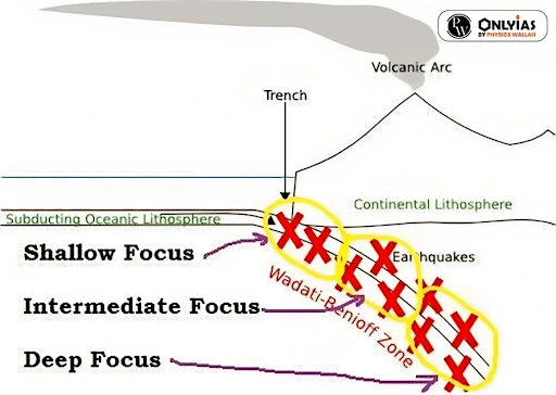
These earthquakes are divided into three zones: Shallow, Intermediate, and Deep based on their depth which range between 0 – 700 km.
- Shallow Earthquakes (Focus 0 – 70 km Deep): The great majority of earthquakes have shallow-focus.
-
- Hence, they are also called ‘crustal earthquakes.’
- Shallow focus earthquakes can cause relatively greater damage at the surface (as the whole energy is directed towards a small area) compared to their deep-focus counterparts.
- About 75% of the total energy released from earthquakes is from shallow-focus ones.
- Eg. Italy (2016), Cianjur in West Java(2022)
- Intermediate Earthquakes (Focus 70 – 300 km Deep)
-
- Of the total energy released in earthquakes, 12 percent comes from intermediate earthquakes.
-
- In the intermediate range, the frequency of occurrence falls down with increasing focal depth.
-
- Eg. Romania (1940), Indonesia(2009)
- Deep Earthquakes (focus 300 – 700 km Deep)
-
- Wadati–Benioff zone (zone of subduction): This zone indicates the presence of a subducting slab and deep focus earthquakes occur here.
- A Wadati–Benioff zone is a planar zone of seismicity corresponding with the down-going slab in a subduction zone.
- They do not cause much destruction because the foci of these earthquakes lie very deep and energy of the quakes dissipates over a wide area.
- Eg. Okhotsk Sea Earthquake(2013), Vanuatu(2004)
Measurement of Earthquake Zones: Mercalli and Richter Scale
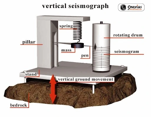
- Seismograph: The seismic waves generated by earthquakes is measured by instrument known as Seismograph
- Seismogram is the recorded graphical output from a seismometer/seismograph
- There are two main scales used in the seismometers:
1) Mercalli Scale:
- This scale represents the intensity of earthquake.
- The range of intensity is from 1-12.
- Isoseismal line is a line on a map connecting points of equal intensity of a particular Earthquake.
- The Meizoseismal area in an earthquake is the area of maximum damage.
2) Richter Scale:
- This scale represents the magnitude of the earthquake.
- The magnitude is expressed in absolute numbers from 1-10
- Each whole number increase in the Richter scale represents a ten times increase in power of an earthquake.
Exploring Earthquake Zones: A Global Perspective and distribution in the world
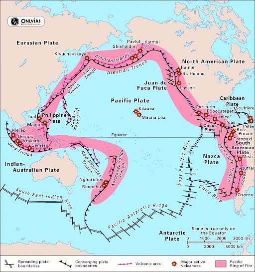
- Circum-Pacific Belt: This is the most important earthquake belt where subduction of Pacific ocean plate beneath the surrounding plate is responsible for earthquakes
- It affects many populated coastal regions around the Pacific Ocean—for example, those of New Zealand, New Guinea, Japan, the Aleutian Islands, Alaska, and the western coasts of North and South America.
- It has been popularly dubbed the “Pacific Ring of Fire” because at many places the Circum-Pacific Belt is associated with volcanic activity,
- The Pacific Ring of Fire accounts for about 68 per cent of all earthquakes.
- Alpine Belt (Himalayas and Alps): The energy released in earthquakes from this belt is about 15 percent of the world total
- The Alpine Belt extends parallel to the equator from Mexico across the Atlantic Ocean, the Mediterranean Sea from Alpine-Caucasus ranges to the Caspian, Himalayan mountains and the adjoining lands.
- Mid Oceanic Ridges: At mid-ocean ridges, plates are being pulled apart, so the oceanic crust gets broken in a system of normal faults.
- Arctic Ocean, the Atlantic Ocean, and the western Indian Ocean—and along the rift valleys of East Africa.
Earthquake Zones in India
- According to the National Disaster Management Authority (NDMA), in India, about 59% of the land area is vulnerable to earthquakes and about 57% of the area lies in high seismic zones.
- In India, earthquakes are primarily caused by the collision of the Indian Plate with the Eurasian Plate.
- This collision has resulted in the formation of the Himalayas, as well as frequent earthquakes in the region.
- Even the peninsular India is prone to damaging earthquakes as clearly illustrated by the Koyna (1967), Latur (1993), and the Jabalpur (1997) earthquakes
- Andaman & Nicobar Islands frequently experience damaging earthquakes due to being situated on an inter-plate boundary
Reasons for the Earthquake Vulnerability in India: Causes and Consequences
- Movement of Indian Plate: The Indian plate is driving into Eurasia at a rate of approximately 47 mm/year.
- Himalayan belt: Collision between Indo-Australian plate with Eurasian plate causes lots of strain in underlying rocks’ energy, which is released in the form of earthquakes.
- Andaman and Nicobar Islands: Seafloor displacement and underwater volcanoes disturb the equilibrium of earth’s surface.
- Deccan Plateau: Energy build-up and the emergence of a fault line along the fault line of the river Bhima (Krishna) near Latur and Osmanabad (Maharashtra).
Earthquake Zones: Understanding the Risk Associated
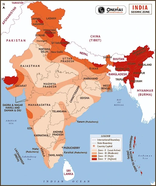
- Bureau of Indian Standards (BIS) prepared the seismic zoning map of India
- India has been divided into four zones – II, III, IV and V
- Zone V is seismically the most active region, while Zone II is the least.
- Around 11% of the country falls in Zone V, 18% in Zone IV, 30% in Zone III and the remaining in Zone II.
Revealing the Aftermath: Consequences of Earthquakes on People and Infrastructure
- Physiographic Impacts: Severe damage to buildings and other rigid structures.
- Ground rupture damages large engineering structures such as dams, bridges and nuclear power stations.
- Landslides and avalanches: Earthquakes can produce slope instability leading to landslides along with severe storms, volcanic activity, and coastal wave attack Fires.
- Earthquakes can cause fires by damaging electrical power or gas lines.
- Eg.1906 San Francisco earthquake.
- Soil liquefaction: Soil liquefaction may cause rigid structures, like buildings and bridges, to tilt or sink.
- Tsunami: Earthquakes can also lead to Tsunami due to abrupt movement of large volumes of water.
-
- The Tsunami of 26th December 2004 of the Indian Ocean was caused by an earthquake off coast of Sumatra.
- Socio-Economic Impacts: Around 56% of the total deaths or 747,234 lives were lost between 1998 to 2017.
-
- Economic Effects: Earthquakes can damage infrastructure, disrupt supply chains, and cause inflation.
-
- As per the World Bank, 10% infrastructural damage is due to the earthquakes.
| UPSC PYQs
Prelims: Q. Consider the following statements:(UPSC 2023
Answer: C Mains: Q. The frequency of earthquakes appears to have increased in the Indian subcontinent. However, India’s preparedness for mitigating their impact has significant gaps. Discuss various aspects. (2015) Q. Discuss about the vulnerability of India to earthquake related hazards. Give examples including the salient features of major disasters caused by earthquakes in different parts of India during the last three decades. (2021) |