Books

Learn about the Indus River System; Its Map, origin, major tributaries, course, dams, basin area, and the Indus Water Treaty. Understand its historical, geographical, and economic significance.

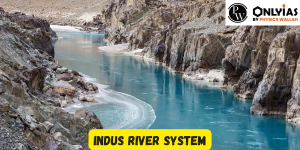
Indus River System is one of the world’s largest and most ancient river basins. Originating in the Himalayas, it flows through India and Pakistan, sustaining fertile lands and diverse ecosystems. Comprising the Indus, Jhelum, Chenab, Ravi, Beas, and Satluj rivers, it has significantly influenced the history and culture of South Asia. The Indus Water Treaty (1960) governs water sharing between India and Pakistan, with Pakistan controlling Indus, Jhelum, and Chenab, while India manages Ravi, Beas, and Satluj.
In India, the system spans multiple states. In Jammu and Kashmir, the Indus, Jhelum, Chenab, and Ravi flow. Himachal Pradesh is crossed by Beas, Satluj, and Rabi rivers. Punjab is home to the Satluj, Beas, Rabi, Chenab, and Ghaggar rivers. This intricate network is vital for agriculture, water supply, and ecosystems in the region.
The Indus River system is one of the most prominent river systems in South Asia, forming the backbone of water resources for Pakistan and parts of India. It comprises the main Indus River and a network of significant tributaries flowing through diverse terrains—mountains, valleys, plains, and deltas.
Explore UPSC Foundation Courses

Explore UPSC Foundation Courses
The Indus sustains millions of lives and plays a central role in regional agriculture, ecology, and hydropower generation.
| Indus River System Overview | |
|---|---|
| Feature | Description |
| Total Length | Over 3,000 km |
| Origin | Glacier near Bokhar Chu, Kailash Range, Tibet |
| Entry into India | Demchok in Ladakh |
| Entry into Pakistan | Near the region of Skardu |
| Mouth | Arabian Sea near Karachi, Sindh, Pakistan |
| Total Basin Area | Approximately 1.1 million sq. km |
| Countries Covered | China (Tibet), India, Pakistan |
| Major Left-Bank Tributaries | Zanskar, Suru, Soan, Jhelum, Chenab, Ravi, Beas, Satluj, Panjnad |
| Major Right-Bank Tributaries | Shyok, Gilgit, Hunza, Swat, Kabul, Kurram, Gomal, Tochi |
| Important Dams | Bhakra-Nangal, Ranjit Sagar, Tarbela, Mangla |
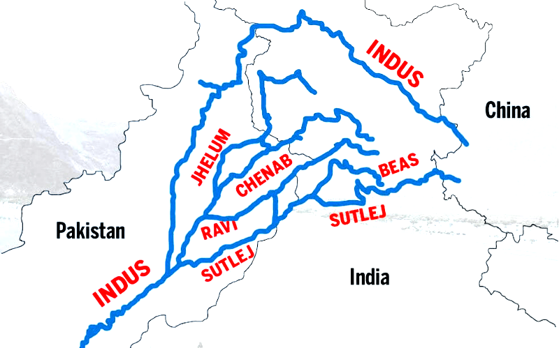
The Indus River System, a vital Himalayan river network, encompasses a rich tapestry of tributaries that play a pivotal role in shaping the landscape and sustenance of the Indian subcontinent. The intricate interplay of rivers like the Indus, Jhelum, Chenab, Ravi, Beas, and Satluj forms the intricate veins of this extensive system.
These tributaries not only contribute to the region’s water resources but also hold historical, cultural, and ecological significance. In this article, we will delve into the origins, courses, and multifaceted contributions of the tributaries within the Indus River System, offering insights into their roles in agriculture, hydroelectric projects, and the region’s overall vitality.
| Rivers | Place of Origin | Tributaries | Multipurpose Projects | States |
| Beas | Near Rohtang Pass,
Beas Kund-H.P (southern end at Pir Panjal) |
Parbati – Created problems in Alexander’s invasion of India 2014, Beas River | Beas Project, Pong Dam, Pandoh Dam | Punjab and Haryana |
| Chenab | Lahaul and Spiti district of Himachal Pradesh: Bara Lacha pass | Headward Tributaries: Chandra(Zozi La), Bhaga (Baracha La), R. Tavi | Salal Project, Dhulhasti Dam, Baglihar Dam, Trimmu Barrage | Himachal Pradesh, J&K |
| Indus | Bokhar Chu- Near Manasarovar lake, Tibet | Zaskar (Ladakh), Astor (Nanga Parbat), Chenab, Sutlej, Soan, Beas, Ravi, Dras, Suru (Indus), Jhelum, Kishanganga, R. Shyok, Gilgit | Kishanganga, Mangla Dam (Jhelum), Tarbela Dam (Indus), Ghazi Barotha Hydroelectric Project | J&K, Distribution as per IWT, 1960 |
| Jhelum | Verinag spring (Pir Panjal Range) | Kishanganga (Right), Neelum, Kunhar, Poonch | Mangla Dam, Rasul Barrage | J&K |
| Ravi | Kullu hills, West to Rohtang Pass | R. Soul (Valley: Rich timber trees Garden of Chamba), R. Budhil, R. Nai/Dhona | Thein (Ranjit Sagar) Dam | J&K |
| Satluj | Manasarovar- Rakas Lakes, Enters India through Shipki la Pass | T Spiti, Proposal to build a 214- kilometer (133 mi) long heavy freight canal, to be known as the Sutlej-Yamuna Link (SYL) in India to connect the Sutlej and Yamuna rivers | Bhakra Nangal Project, Harike, Sirhind, Gobind Ballabh Sagar, Karcham Wangtoo Hydroelectric Plant, Neptha Jhakhari Dam | Punjab, HP, North of the Vindhya Range, South of the Hindu Kush segment of the Himalayas, and East of the Central Sulaiman Range in Pak. |
Understanding the tributaries of the Indus is key to learning its hydrological significance. These tributaries—both left and right bank—contribute to the river’s volume and support large populations along their courses.
This map of the Indus River system typically shows its origin in Tibet and the branching pattern of rivers as they flow through the Indian subcontinent into Pakistan. This spatial awareness helps understand the flow patterns and regional dependencies.
Explore UPSC Prarambh Course

Explore UPSC Prarambh Course
The Indus River system can be split into two major tributary networks:
Left-bank tributaries: These include rivers like the Jhelum, Chenab, Ravi, Beas, and Satluj, which largely originate in India and are essential to the Punjab region.
Right-bank tributaries: Originating in the Karakoram and Hindu Kush ranges, these include the Shyok, Gilgit, Swat, Kabul, and Kurram rivers.
Maps of this river system are often used by geographers, policymakers, and engineers to plan irrigation, flood control, and water-sharing policies.
The tributaries of the Indus River flow from different directions and join the main river from the north to the south. This north-to-south gradient forms the natural drainage pattern that sustains multiple climatic zones and agricultural belts.
Knowing the order in which these tributaries merge with the Indus is crucial for understanding sediment flow, irrigation sequencing, and regional hydrology. Below is the order of major tributaries flowing from north to south.
| Indus River Tributaries North to South | |||
|---|---|---|---|
| Tributary | Origin | Key Regions Traversed | Flow Direction |
| Jhelum | Verinag, Jammu & Kashmir | Jammu & Kashmir, Pakistan | Joins near Jhelum |
| Chenab | Bara Lacha Pass, Himachal Pradesh | Himachal Pradesh, Punjab | Joins near Panjnad |
| Ravi | Kangra District, Himachal Pradesh | Punjab, Pakistan | Joins Chenab |
| Beas | Rohtang Pass, Himachal Pradesh | Himachal Pradesh, Punjab | Joins Satluj |
| Satluj | Rakshastal Lake, Tibet | Himachal Pradesh, Punjab, Pakistan | Joins Indus at Panjnad |
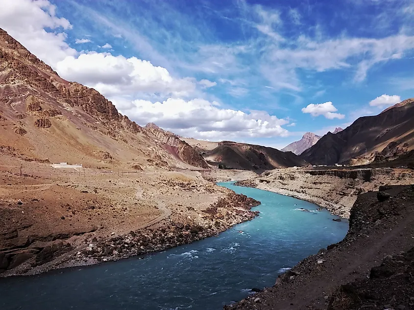
The origin of the Indus River lies high in the Himalayas, within the Tibetan Plateau near Lake Mansarovar. It emerges from a glacier near Bokhar Chu in the Kailash Mountain range, an area that holds immense geographical and spiritual significance.
As it begins its journey, the river is called ‘Singi Khamban’ in Tibet, meaning “Lion’s Mouth.” The river flows northwest from the Tibetan Plateau, entering the Indian territory at Demchok in Ladakh, a Union Territory of India.
In India, the river travels between the Karakoram and Ladakh ranges, gathering pace and strength before eventually making its way into Pakistan. The early stages of the Indus River are characterised by deep gorges, high-altitude valleys, and minimal human settlement, emphasizing its glacial origins and raw natural power.
In India, the course of the Indus River is confined to the Leh region of Jammu & Kashmir. Emerging from a spring at Verinag, situated at the foothills of the Pir Panjal range in the southern part of the Kashmir valley, the Jhelum, a significant tributary of the Indus, originates. It flows through Srinagar and the Wular Lake before entering Pakistan through a narrow and deep valley.
In close proximity to Jhang in Pakistan, it converges with the Chenab River. The Chenab, the largest tributary of the Indus, is formed by the confluence of two streams, the Chandra and the Bhaga, near Keylong in Himachal Pradesh. This gives rise to its alternate name, Chandrabhaga.
The river covers a distance of 1,180 kilometers before entering Pakistan. Another notable tributary of the Indus is the Ravi, which originates west of the Rohtang Pass in the Kullu Hills of Himachal Pradesh. It traverses the Chamba Valley, draining the region between the southern Pir Panjal and Dhauladhar ranges, before merging with the Chenab near Sarai Sidhu. The Beas, another significant tributary, takes its source from the Beas Kund, located at an elevation of around 4,000 meters close to the Rohtang Pass.
As it flows through the Kullu Valley, it creates canyons at Kati and Largi in the Dhauladhar Mountains. Upon reaching the Punjab plains, it joins the Satluj River near Harike.
The Indus River System is one of the most extensive river systems in the subcontinent, covering a total distance of 2,900 kilometres. The overall drainage area of the Indus River System is approximately 1,165,000 square kilometres, with a significant portion falling within the borders of Pakistan. The following provides an overview of the rivers that constitute the Indus River System and their points of origin:
The primary river of the system, the Indus River, originates from the glaciers of the Kailash range near Mansarovar Lake. It stretches for about 2,880 kilometres, with only 710 kilometres flowing through the Indian state of Jammu & Kashmir, while the remainder flows through Pakistan and Tibet. The river commences from a glacier in Tibet’s Bokhar Chu region, close to Manasarovar Lake. Its landscape is mainly characterised by the Himalayan Mountains, Hindu Kush, and Karakoram Range, with the addition of Pakistan’s semi-arid plains.
The Jhelum River, also known as Vitusta in the Rgveda, Hydaspes in Greek, and Veth in Kashmir, is the next significant component of the Indus River System. Originating from the Chashma Verinag glacier, it traverses a distance of approximately 720 kilometers before joining the Chenab River in Pakistan. The Jhelum River enters Pakistan after flowing through the Indian state of Jammu & Kashmir.
The Chenab River, also referred to as Asskini Chandrabhaga, is another vital tributary of the Indus River System. It forms when the Chandra and Bhaga rivers converge in the Western Himalayan region of Himachal Pradesh. The primary water source for these streams is the Baralacha La Pass. Before merging with the Indus River, the Chenab River courses through Himachal Pradesh and Jammu and Kashmir. It stands as the largest tributary of the Indus River System.
Following in sequence is the Ravi River, also known as Iravati or “The River of Lahore.” The Ravi originates near the Rohtang Pass in Himachal Pradesh’s Chamba district. After covering a distance of about 720 kilometers, it joins the Chenab River in Pakistan. The Ravi passes through Shahdara Bagh, which contains the tombs of Jahangir and Noor Jahan, situated between the Pir Panjal and Dhauladhar Ranges.
A significant contributor to the Indus River System is the Beas River. Its journey commences from the Beas Kund in Himachal Pradesh’s Rohtang La pass. The Beas flows for approximately 470 kilometers, merging with the Satluj River in Punjab. As a result, the Beas traverses the Indian states of Punjab and Himachal Pradesh.
The Satluj River is among the most crucial tributaries of the Indus River. Among all the tributaries within the Indus River System, the Satluj boasts the longest course. Its source, the Rakkas Lake or Lake Rakshastal, is located in Pakistan. The Satluj River then flows through the states of Himachal Pradesh and Punjab in India, finally entering India through the Shipki La Pass and joining the Chenab River. The total length of the Satluj River is 1,450 kilometers, with 1,050 kilometers situated within Indian territory.
The Indus River System boasts a rich historical legacy, serving as the birthplace of one of the world’s earliest urban civilizations, the Indus Valley Civilization. Flourishing around 3300 BCE, this advanced civilisation thrived along the banks of the Indus and its tributaries. Archaeological discoveries reveal intricate urban planning, advanced drainage systems, and an intricate trade network that spanned regions as far as Mesopotamia.
The fertile alluvial plains irrigated by the Indus River System have facilitated agriculture for millennia. The waters from the river and its tributaries are harnessed for irrigation through an extensive network of canals and dams. The region is a major producer of crops such as rice, wheat, cotton, and sugarcane, contributing significantly to the economies of countries within the system.
Apart from its agricultural significance, the Indus River System has a substantial hydropower potential. Dams and hydroelectric projects have been constructed along its course to generate electricity and provide energy to industries and households. Projects like the Tarbela Dam and the Mangla Dam in Pakistan stand as monumental examples of harnessing the river’s power for economic development.
The Indus River System faces numerous challenges stemming from over-extraction, pollution, and ecosystem degradation. Rapid population growth, industrialization, and inadequate waste management practices contribute to the pollution of these vital water sources. Balancing the needs of economic development with environmental conservation remains a critical concern.
Several of the Indus River’s tributaries flow through multiple countries, leading to intricate water-sharing arrangements and occasional tensions. The Indus Waters Treaty of 1960, brokered by the World Bank, delineates the sharing of river waters between India and Pakistan. The treaty’s success in maintaining relative stability in water-sharing highlights the significance of international cooperation in managing shared resources.
The Indus River System, with its vast network of rivers and tributaries, is a significant source of hydroelectric power in South Asia. The system hosts several major hydroelectric projects that provide renewable energy and support agricultural and industrial activities in the region. Below is a table detailing the key hydroelectric projects on the Indus River and its tributaries.
| Project Name | River | Location | Installed Capacity (MW) | Country |
|---|---|---|---|---|
| Bhakra Dam | Satluj | Himachal Pradesh, India | 1,325 MW | India |
| Pandoh Dam | Beas | Himachal Pradesh, India | 990 MW (Dehar Power Plant) | India |
| Baglihar Dam | Chenab | Jammu & Kashmir, India | 900 MW | India |
| Uri Hydroelectric | Jhelum | Jammu & Kashmir, India | 480 MW | India |
| Tarbela Dam | Indus | Khyber Pakhtunkhwa, Pakistan | 4,888 MW | Pakistan |
| Mangla Dam | Jhelum | Punjab, Pakistan | 1,000 MW | Pakistan |
| Kishanganga Project | Kishanganga (Jhelum tributary) | Jammu & Kashmir, India | 330 MW | India |
| Dhulhasti Project | Chenab | Jammu & Kashmir, India | 390 MW | India |
| Neelum-Jhelum Project | Jhelum | Pakistan-administered Kashmir | 969 MW | Pakistan |
Climate change poses a grave threat to the Indus River System, impacting water availability, glacial melt, and monsoon patterns. The receding glaciers in the Himalayas and alterations in precipitation patterns could disrupt the delicate balance of water supply, posing challenges for water resource management and agricultural sustainability.
The Indus River System, spanning centuries and civilisations, stands as a testament to the intricate relationship between humans and their environment. It has witnessed the rise and fall of civilisations, the evolution of economies, and the challenges of modernisation. As nations grapple with the imperatives of development and conservation, the Indus River System remains a symbol of resilience, adaptation, and the interconnectedness of all life along its banks.
India has undertaken projects like the Indira Gandhi Nahar Project, Beas-Sutlej Link, and Madhopur-Beas Link to make effective use of approximately 95% of the water from Eastern Rivers. The Shahpurkandi Project aims to utilize water from Thein Dam’s powerhouse for irrigation and power generation in Punjab and Jammu & Kashmir. The construction work for this project is being carried out by the Punjab government under Indian government supervision.
The major rivers of the Indus River System include the Indus, Jhelum, Chenab, Ravi, Beas, and Sutlej. While a small portion extends to China and Afghanistan, the basin is primarily shared by India and Pakistan. India has been granted permission to harness the potential of run-of-river (RoR) projects on the Western Rivers for hydroelectricity generation, subject to specific design and operational requirements.
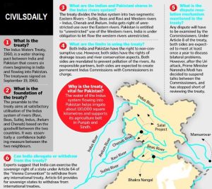
India and Pakistan signed the Indus Water Treaty in 1960 as a water distribution agreement. Jawaharlal Nehru, the prime minister of India at the time, and Ayub Khan, the president of Pakistan at the time, signed the Indus Water Treaty. The conference between the two nations over the Indus Water Treaty was organized by the World Bank. The Indus Water Treaty was drafted by the World Bank in 1954 based on the UN’s (Permanent Indus Commission) recommendations, and it was signed on September 19, 1960. A structure for collaboration and information sharing between the two parties on the usage of the water of the Indus River and its five tributaries: the Sutlej, Beas, Ravi, Jhelum, and Chenab is outlined in the treaty.
Check Out UPSC CSE Books
Visit PW Store
Explore UPSC Test Series

The Indus River System comprises the main tributaries of the Indus River: the Indus, Jhelum, Chenab, Ravi, Beas, and Satluj rivers. Due to the Indus River's course spanning both India and Pakistan, the Indus Water Treaty was established in 1960 to regulate the sharing of its waters between the two countries.
The convergence of the Satluj, Beas, Ravi, Chenab, and Jhelum rivers occurs as they flow together into the Indus River, eventually reaching the vicinity of Karachi in Pakistan.
Within India, the Indus basin extends across the regions of Jammu & Kashmir, Himachal Pradesh, Punjab, as well as portions of Rajasthan, Haryana, and the Union Territory of Chandigarh, encompassing a land area measuring 321,289 square kilometers.
The Indus River System is located primarily in South Asia. It flows through multiple countries, including India, China, Afghanistan, and Pakistan. The major portion of the Indus River and its tributaries is situated in Pakistan, where it plays a significant role in the country's water resources and agriculture. In India, the Indus River System traverses the regions of Jammu & Kashmir, Himachal Pradesh, Punjab, and parts of Rajasthan, Haryana, and the Union Territory of Chandigarh. The Indus River System is a vital geographical feature of the Indian subcontinent.


Explore SRIJAN Prelims Crash Course

Connect with our experts to get free counselling & start preparing
Books
Udaan (Prelims Wallah)
Prahaar (Mains Wallah)
Q&A Bank (Prelims & Mains)
Budget & Economic Survey
NCERT Wallah
Marks Booster
हिंदी माध्यम विशेष शृंखला
 Current Affairs
Monthly Current Wallah
Subject Wise Current Affairs
Editorial Analysis
Editorial PDFs
News of The Day
Download Our App


Download Our App
<div class="new-fform">
</div>


 GS Foundation
 Optional Course
 Combo Courses
 Degree Program