Subject: GS 3: Disaster Management
Context: Recently, the National Mission for Clean Ganga (NMCG) amended the River Ganga (Rejuvenation, Protection and Management) Authorities Order, 2016, easing restrictions on construction in parts of the Ganga flood plain.
- The amendment replaces the earlier blanket “construction-free zone” approach with a risk-based, stratified regulatory framework.
- Construction remains prohibited in the active flood plain, while regulated development may be permitted in areas facing less frequent flooding, subject to approvals and environmental safeguards.
UPSC Coaching Classes
Basis for the Amendment
- The earlier framework referred to an “active flood plain” without clearly defining it, creating regulatory ambiguity.
- The Central Water Commission’s July 2025 guidelines provided a more differentiated classification of flood plains into active, regulatory, and warning zones based on flood frequency.
- The latest amendment seeks to incorporate this approach into the Ganga regulatory framework.
About National Mission for Clean Ganga (NMCG)
- Establishment: Set up in 2011 as a registered society under the Societies Registration Act, 1860; functions under the Ministry of Jal Shakti.
- Role: Serves as the implementation arm for the Namami Gange Programme and works towards Ganga rejuvenation and pollution abatement.
- Objectives: Ensures “Nirmal Dhara” (unpolluted flow), “Aviral Dhara” (continuous flow), and protection of the Ganga’s ecological integrity.
- Key Activities: Sewage treatment, industrial pollution control, biodiversity conservation, afforestation, riverfront management, and restoration of aquatic ecosystems.
- Institutional Framework: Works through the National Ganga Council, State Ganga Committees, and District Ganga Committees for coordinated implementation.
|
About Ganga Flood Plains
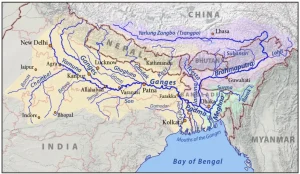
A flood plain is the relatively flat area adjoining a river that becomes inundated during floods. It performs important ecological and hydrological functions by:
- Facilitating groundwater recharge.
- Absorbing and temporarily storing floodwaters.
- Supporting wetlands and riverine ecosystems.
- Providing space for the natural movement of the river.
- Reducing the intensity of downstream flooding.
- Unplanned construction on flood plains can obstruct natural drainage, increase flood risk, reduce groundwater recharge, and damage river ecosystems.
Key Changes in the Framework
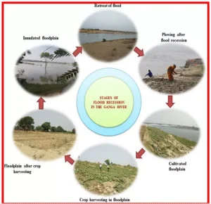
- Removal of Blanket Construction Ban: The amendment removes the earlier provision declaring the Ganga riverbank and flood plain a construction-free zone.
- Active Flood Plain: The area immediately adjoining the river channel that is inundated at least once every five years has been designated as the active flood plain. Construction remains largely prohibited in this zone, with limited exceptions such as temporary religious activities.
- Regulatory Zone: Areas experiencing moderate flooding once every five to 25 years have been classified as the regulatory zone. Development may be permitted subject to regulatory clearances.
- Warning Zone: The outer flood-plain area exposed to severe flooding occurring once every 25 to 100 years has been designated as the warning zone. Construction in this zone is also subject to official approvals and safeguards.
- Prior Approvals: Projects such as roads, bridges, riverfront infrastructure, and other developments continue to require approval from the National Mission for Clean Ganga and relevant regional authorities.
Concerns and Challenges
- Risk of Increased Flood Vulnerability: Permitting construction beyond the five-year flood line could encourage development in areas that may still experience severe but less frequent floods.
- Climate Change Uncertainty: Historical flood frequencies may no longer accurately represent future risks because climate change is altering rainfall intensity, river discharge, and the frequency of extreme floods.
- Encroachment and Enforcement: Weak enforcement and rapid urbanisation could result in gradual encroachment into regulated zones, increasing future disaster risk.
- Ecological Degradation: Construction may affect wetlands, groundwater recharge, riparian ecosystems, and natural drainage channels, even outside the active flood plain.
- Fragmented Governance: Effective flood-plain management requires coordination among the NMCG, Central Water Commission, State governments, urban local bodies, and environmental authorities.
- Legal Challenges: The change could invite further scrutiny before institutions such as the National Green Tribunal, particularly in cases involving riverfront infrastructure and construction along Ganga tributaries such as the Gomti.
Way Forward
- Adopt Climate-Resilient Flood Mapping: Flood zones should incorporate projected climate risks, changing rainfall patterns, and extreme-flood scenarios rather than relying solely on historical data.
- Strengthen Flood-Plain Zoning: States should develop legally enforceable flood-plain zoning regulations based on scientific hydrological assessments.
- Prioritise Nature-Based Solutions: Restoration of wetlands, floodplain forests, riparian buffers, and natural drainage channels can reduce flood risk while improving river ecology.
- Ensure Cumulative Impact Assessment: Major infrastructure projects should consider their combined impact on river flow, flood storage, groundwater recharge, and downstream communities.
- Strengthen Enforcement: Digital flood maps, satellite monitoring, public disclosure of approvals, and strict penalties can help prevent unauthorised construction and encroachment.
Click to Know UPSC Offline Courses
Conclusion
The revised framework marks a shift from a uniform construction ban to risk-based flood-plain management. Its success depends on science-based zoning, climate-resilient planning, strict enforcement, and protection of the Ganga’s ecological functions.
 12 Aug 2026