Context
The government has heightened security focus on the strategic Andaman and Nicobar Islands (ANI).
Enroll now for UPSC Online Course
Why are Andaman and Nicobar Islands key to Indo-Pacific Security?
- Military Infrastructure Upgrade: The military infrastructure upgrade is undergoing in the Andaman and Nicobar Islands (ANI), with revamped airfields and jetties, additional logistics and storage facilities, a habitat for troops, and a robust surveillance infrastructure.
- Container Transhipment Terminal: The Centre is also working to construct a container transhipment terminal alongside associated infrastructure to support traffic and operations.
- Objective Behind Infrastructure Upgradation: The enhancement of security infrastructure is part of a comprehensive strategy aimed at:
- Transforming the Andaman and Nicobar Islands into a formidable maritime stronghold and fostering cooperation with maritime neighbors.
- It could serve as a platform for cooperative maritime endeavors like aircraft and submarine search and rescue missions.
- It will facilitate deployment of additional military forces, and facilities for larger and more warships, aircraft, missile batteries and troops.
- Chinese Increasing Influence: This is being done amid Chinese attempts to expand its influence in the region, which includes the construction of a military facility at Myanmar’s Coco Islands lying 55 km north of Andaman and Nicobar Islands (ANI).
Andaman and Nicobar Islands (ANI)
- Group of Islands: The Andaman and Nicobar Islands (ANI) consists of two groups of islands, the Andaman Islands and the Nicobar Islands, covering an area of 8,249 sq km.
- The entire island chain consists of 836 islands, including islets and rocky outcrops, of which some 38 are permanently inhabited.
- Governance: The islands are governed as a single Union Territory by the Central Government of India through the Andaman Nicobar Administration.
- Integrated Tri-service Command: The Andaman and Nicobar Islands is home to India’s only integrated tri-service command of the armed forces, the Andaman and Nicobar Command (ANC), responsible for maritime surveillance and enhancing India’s strategic presence in the eastern Indian Ocean.
Andaman and Nicobar Islands (ANI) As Key to Indo-Pacific Security
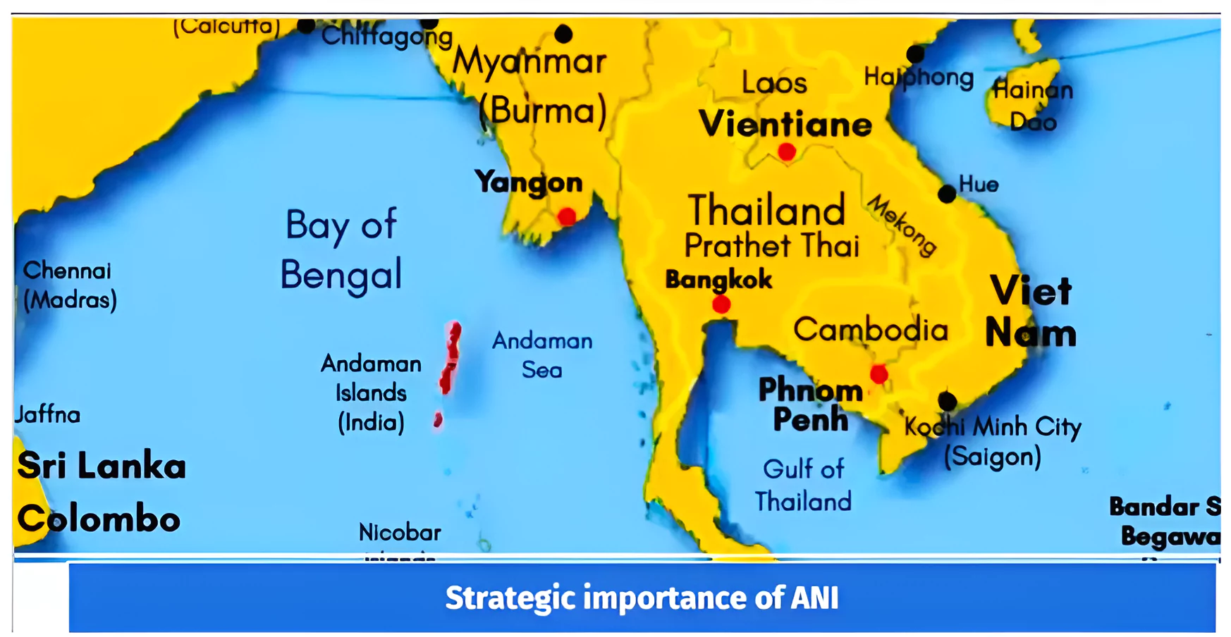
- Strategic Location and Maritime Chokepoints: Situated at the entrance of the Strait of Malacca, the long chain of Andaman and Nicobar Islands (ANI) connects one of the world’s most crucial trade chokepoints.
- They offer India the capability to monitor traffic flow from the South China Sea (Pacific Ocean) to the Andaman Sea (Indian Ocean).
- Proximity to Key Maritime Routes and Shipping Lanes: The ANI commands a position over one of the world’s most frequented sea lanes.
What is the Indo-Pacific Region?
- The term “Indo-Pacific region” recently gained prominence and refers to a geopolitical concept surrounding a vast maritime area in the Indian Ocean and Pacific Ocean.
- It spans from the eastern coast of Africa to the western coast of the Americas and is strategically significant due to its major trade route, important sea lanes, and critical maritime chokepoints it contains.
|
-
- This positioning allows India to oversee the movement from the South China Sea (Pacific Ocean) to the Andaman Sea (Indian Ocean) through the Strait of Malacca.
- Nearly 70,000 1,20,000 ships sailing through the Indian Ocean pass-through the Strait of Malacca and the neighbouring Six Degrees channel.
- Potential for Power Projection and Maritime Domain Awareness: Port Blair, the capital of these islands, is just 20 nautical miles away from Myanmar, and the southern point, known as Indira Point, is 90 nautical miles away from Indonesia.
- Hence this should help India counter China’s ‘String of Pearls’ strategy due to its closeness to the ‘Strait of Malacca’ chokehold.
- Proximity to Southeast Asia: The Andaman and Nicobar Islands are located close to Southeast Asia (and the Association of SouthEast Asian Nation countries) which are central to the country’s Indo-Pacific vision.
- Counterbalancing the Chinese Influence: The increasing Chinese influence in the littoral states using the “string of pearls” strategy can be counterbalanced by India’s push towards developing ANI using the ‘SAGAR MALA‘ initiative and Act East Policy.
- Surveillance and Power Projection: Andaman and Nicobar Islands could provide multiple military operations for India to keep the busiest sea lanes under surveillance and for power projection.
- It will enhance India’s underwater maritime domain awareness in this region, like the US-Japan “Fish Hook” SOSUS network in the South China Sea and the Indian Ocean Rim.
- This is a significant part of controlling, monitoring the Chinese influence, and tracking the movements of Chinese submarines in the deep Indo-Pacific region.
- Net Security Provider: India can leverage the potential of these islands to protect its own interests and enhance its image as the ‘net security provider’ in the region.
- Important Fulcrum of Indo-Pacific: The Andaman and Nicobar Islands is at the intersection of the Indian Ocean, the South China Sea, and the Pacific Ocean, an important fulcrum of the Indo-Pacific’s strategic concept.
Enroll now for UPSC Online Classes
Challenges in Andaman and Nicobar Islands’s Strategic Development
- Vulnerability of Choke Points: Maritime choke points constitute critical vulnerabilities for world trade and commerce, as visible from the severe disruption and rerouting of shipping caused by the Houthi attacks in the Red Sea.
- China’s Expansion: As part of its Maritime Silk Road initiative, China has been funding and executing new ports and modernizing existing ports in many countries along the IOR. Ex-It developed new bases at Gwadar and Djibouti.
- The Trilateral Highway Project in Myanmar, Hambantota port at Sri Lanka, which is under ninety-nine years of lease under China, is the classic example of China’s Debt Trap Diplomacy.
- Untapped Potential of Andaman and Nicobar Islands (ANI): Despite the presence of all three services, the ANC has yet to realize its potential. The command has limited assets and presence in comparison to a theater-level presence of a joint command.
- While it has the potential to be the forward operating base for all of India’s engagements with Southeast Asia, it mainly acts as a logistical facility for deployments of India’s Eastern Naval Command to East and Southeast Asia.
- Slow Pace of Development: Internet connectivity is reported to be erratic. Road building, airstrip construction, and even the building of jetties have been slow or nonexistent.
- Vulnerability to Non-state Actors: The absence of a human presence on hundreds of these islands has made them vulnerable to narcotics smuggling, intrusion by foreign vessels, and other incursions.
- Remote Location: Few companies are willing to work on the islands because of the distance and cost.
- For some materials, importing from Indonesia would be far cheaper and more cost-effective than sending shipments from the Indian mainland.
- Developmental Challenges: Developing these islands carries massive environmental, sustainability, and tribal welfare challenges.
- There is an island-wide restriction on clearing land for development, and 94.68 per cent of the islands are under forest cover.
- The presence of indigenous tribes on the islands has also restricted commercial activities and development in tribal areas.
Government Interventions for Development of Andaman and Nicobar Islands (ANI)
- National Remote Sensing Centre (NRSC): The NRSC, based in Hyderabad, manages satellite data processing and disaster management.
- The government has requested the NRSC to increase resources for satellite image analysis and data dissemination for 55 inhabited islands in ANI and Lakshadweep.
- Multi-Agency Maritime Security Group (MAMSG) meeting: The Ministry of Home Affairs recently organized a MAMSG meeting to discuss surveillance of uninhabited islands.
- Modern Hangar and Dispersal system: They were inaugurated at INS Utkrosh in Port Blair.
- Precision Approach Radar (PAR): It was inaugurated at INS Utkrosh to enable accurate horizontal and vertical guidance to land an aircraft safely in low visibility conditions.
- NITI Aayog’s Holistic Development Program for the islands: It aims to provide a framework for developing a new ‘greenfield city’ with a diverse and robust economy based on maritime services and tourism.
- Maritime Hub: In 2015, the government announced an INR 100,000 million plan to develop the islands into the country’s first maritime hub.
-
- It aims to develop facilities, such as telecommunications, electricity, and water, which will help build and expand strategic capabilities.
- Declining Protectionism: In 2019, a new Island Coastal Regulation Zone Notification was promulgated, allowing land reclamation for ports, harbours and jetties.
- Maritime Exercises: ANC conducts joint maritime exercises such as the Singapore-India Maritime Bilateral Exercise and Coordinated Patrols with Myanmar, Thailand and Indonesia.
- Expanding Naval Presence: Following the Ladakh stand-off with China in May 2020, India is expediting plans for stationing additional forces, warships, aircraft, and missile batteries in the Andaman and Nicobar Islands (ANI).
- There have also been reports of naval air stations INS BAAZ and INS KOHASSA expanding their support operations.
Lakshadweep Islands
- Lakshadweep is an archipelago of 36 islands in the Arabian Sea, about 440 km from the coast of Kerala.
- Location: Lakshadweep islands are the northernmost part of the Lakshadweep–Maldives–Chagos group of islands, which are the exposed tops of a vast undersea mountain range, the Chagos-Lakshadweep Ridge.
Significance:
- Naval Outpost: Lakshadweep islands can serve as the naval outpost for Indian Naval assets deployed in the Arabian Sea.
- Shipping Lines: The nine-degree channel near Lakshadweep is the shortest way for ships connecting West and East Asia.
- Strategic Tool: Lakshadweep development can be used by India as a bargaining chip while dealing with China-favouring administration of Maldives.
|
Way Forward
- Maintaining Comprehensive Maritime Domain Awareness (MDA): MDA through the ANI is critical, especially in monitoring sub-surface vessels.
- This could be done by utilizing a variety of networked assets such as radars, aircraft, satellites, and unmanned vehicles. .
- Anti-submarine Warfare Capability: The frequent passages of People’s Liberation Army Navy (PLAN) warships, submarines, and research/intelligence-gathering vessels in these waters suggest a sustained Chinese naval presence, including nuclear attack submarines.
- This necessitates the Indian Navy to maintain a significant anti-submarine warfare capability in the region.
- Upgrading Communications Infrastructure: India should upgrade the islands’ communications infrastructure and integrate it with MDA facilities on the mainland.
- The current infrastructure is poor and cannot sustain a coherent surveillance strategy.
- Enhancing Military Infrastructure: There is an urgent need to enhance the islands’ intelligence, surveillance, and reconnaissance cover to utilize their potential fully.
- The islands are home to modest military assets and infrastructure with tremendous potential, though underutilised.
- Encouraging Migration: There is a need to consider encouraging migration from the land and opening up some of the strategically located uninhabited islands to tourism.
- This would give India a more robust physical footprint and help the country track the movement of vessels and people.
- Cooperation with Strategic Partners: India must collaborate with its partners, which have specific expertise in this area to advance its development vision.
- For example, India and Japan are building infrastructure and connectivity corridors in the Indian Ocean, including the Asia-Africa Growth corridor. These initiatives provide an opportunity to develop many civilian projects on the islands, like ports and highways.
- Port visits by the US, Japan, Australia, France or the UK can lead to further graded cooperation in the dimensions in the ANI between India and its key strategic partners.
- Engagement with ASEAN: There lies an opportunity to make ANI an important element of the “Act East Policy” of engaging with countries in the region east of India.
- Utilizing Act East Policy: India needs to focus on the holistic development of these islands through strategic investments and increasing military strength in the Andaman and Nicobar Islands to counter China.
Enroll now for UPSC Online Course
Conclusion
As the Indo-Pacific region gains increasing significance and concerns regarding China’s assertive behaviour increase, the international community is uniting to collaborate and ensure the safe conduct of trade in this area. The ANI, therefore, will help India to occupy centre stage in the Global maritime strategy in the years to come.
Also Read: PM Unveil Blueprint For Maritime Blue Economy
| Prelims PYQ (2014):
Which one of the following pairs of islands is separated from each other by the ‘Ten Degree Channel’?
(a) Andman and Nicobar Islands
(b) Nicobar and Sumatra
(c) Maldives and Lakshadweep
(d) Sumatra and Java
Ans: (a) |
 12 Apr 2024