Recently, the Supreme Court has constituted a High-Powered Committee (HPC) headed by the Indian Council of Forestry Research and Education (ICFRE) chief to independently review the scientific definition of the Aravalli hills amid concerns over mining-related environmental impacts.
Key Controversies Over Aravalli Definition
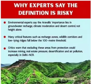
- 100-Metre Height Criterion: The earlier committee proposed that only hills above 100 metres should be classified as part of the Aravalli Range.
- The Forest Survey of India (FSI) warned that this could remove protection from nearly 90% of Aravalli hills.
- Alleged Suppression of Scientific Findings: The Supreme Court’s amicus curiae stated that the earlier report ignored warnings raised by the FSI and objections from the Central Empowered Committee (CEC).
- Large-Scale Hill Exclusion: Under the proposed rule, only 1,048 out of 12,081 hills in Rajasthan would qualify for protection.
- The remaining hills could become vulnerable to mining and real-estate activities.
UPSC Online Coaching
About the High-Powered Committee (HPC)
- The Supreme Court mandated the committee to resolve the legal, scientific, and geographical ambiguities surrounding the definition of the Aravalli hills and submit an independent report by August 31, 2026.
- Committee Chairperson: The HPC is chaired by Kanchan Devi, Director General of the Indian Council of Forestry Research and Education (ICFRE) under the Ministry of Environment, Forest and Climate Change (MoEFCC).
- Expert-Based Composition: The committee includes former officials and experts from:
- Forest Survey of India (FSI)
- Geological Survey of India (GSI)
 Environment Ministry
- Delhi University
- Academic Participation: Experts from the Indian Institute for Human Settlements (IIHS) and the Central University of Haryana have also been included.
- Concerns Over Institutional Independence: Some conservationists raised concerns over possible conflict of interest, since the committee chair reports to a system linked with the earlier report under review.
Major Ecological Issues Under Review
- 500-Metre Distance Rule: The Supreme Court asked whether restricting Aravalli classification to hills located within 500 metres of each other creates loopholes for illegal mining.
- Ecological Continuity: The HPC will examine whether separated hill formations still function as one continuous ecological system requiring collective protection.
- Scientific Validity of Hill Classification: The committee will assess whether the claim that less than 10% of Rajasthan’s hills deserve protection is scientifically justified.
- Regulatory and Legal Gaps: The Court also asked the committee to examine whether weak legal definitions have enabled environmental exploitation in the Aravalli region.
Historical Evolution and Judicial Interventions
- Early and Modern Exploitation: Mining activities date back to the Khetri copper mines (5th century BCE).
- However, large-scale degradation accelerated during the 1960s–80s NCR urban expansion, driven by construction demand.
- Judicial Timeline: In 1992, the Ministry of Environment, Forest and Climate Change (MoEFCC) restricted mining in Alwar and Gurgaon, leaving Faridabad vulnerable..
- During the 1990s, monetisation of “hill homes” intensified pressure.
- In 2009, the Supreme Court imposed a blanket mining ban in Faridabad, Gurugram, and Mewat, asserting “Save the hill, ignore the definition.”
- Despite this, a 2018 assessment reported the disappearance of 31 hills in Rajasthan due to illegal mining.
About Aravalli Hills
The Aravalli Range is among the oldest geological formations on Earth, formed during the Proterozoic era, long before the Himalayas, and forms the ecological backbone of northwest India.
- Geological and Human Evolution: Formed nearly 3.2 billion years ago, the Aravallis evolved from a pristine ecological barrier to a fragmented landscape due to sustained human intervention.
- A relic of ancient fold mountains, representing one of the earliest stable landmasses of the Indian subcontinent.
- Extent & Orientation: Stretches about 670 km in a northeast–southwest direction.
- Geographical Spread: Originates near Himmatnagar (Gujarat), passes through Rajasthan and Haryana, and ends at the Delhi Ridge.
- Topography:
- Southern Aravallis: Steep, rugged, and relatively forested, including Mount Abu.
- Northern Aravallis: Low, rocky ridges with sparse scrub vegetation.
- Highest Peak: Guru Shikhar (1,722 m), located on Mount Abu, Rajasthan.
- Hydrology: Source of important rivers such as the Banas, Luni, Sakhi, and Sabarmati.
- Ecological & Cultural Significance: Hosts key conservation and heritage sites including Sariska Tiger Reserve, Kumbhalgarh Wildlife Sanctuary, and the Delhi Ridge, where ancient geology intersects with urban landscapes.
Click to Know UPSC Offline Courses
Significance of the Aravalli Hills- The Ecological “Kavach” of North India
The Aravalli Range functions as a multi-functional ecological “Kavach” (shield), providing critical environmental services essential for the survival and sustainability of northern India.
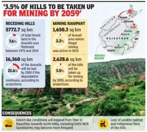
- Barrier Against Desertification & Pollution: The Aravallis act as a natural wall against the eastward expansion of the Thar Desert by influencing wind patterns and preventing sand and dust intrusion into the Indo-Gangetic plains.
- The Aravalli hills influence monsoon patterns and groundwater recharge, contributing around 2 million litres per hectare. Without them, much of the Arabian Sea rainfall would bypass Rajasthan, flowing into Pakistan instead.
- Forest Survey of India (FSI) studies show that gaps in the range allow dust storms, causing PM2.5 and PM10 levels in Delhi-NCR to rise 4–6 times, highlighting their role in air-quality regulation.
- Hydrological Lifeline: The range underpins regional water security through its unique geology, where fractured Alwar Quartzite and marble formations enable high rainwater infiltration.
- Central Ground Water Board (CGWB) data indicates that the Aravallis recharge nearly 20–30% of groundwater in the water-stressed National Capital Region (NCR) and act as the source region for major rivers such as the Luni, Sabarmati, Banas, and Chambal.
- Biodiversity Reservoir & Wildlife Corridors: The Aravallis host 22 wildlife sanctuaries and 4 tiger reserves and function as critical ecological corridors for species like the Indian Leopard and Striped Hyena, ensuring habitat connectivity between landscapes such as Sariska and Ranthambore.
- Climate Regulation Function: Acting as a vast green lung, the range moderates regional temperatures, traps dust, and functions as an important carbon sink, contributing directly to India’s climate-change mitigation and Paris Agreement commitments.
 3 Jun 2026