Introduction: Embracing the Tropic of Capricorn #
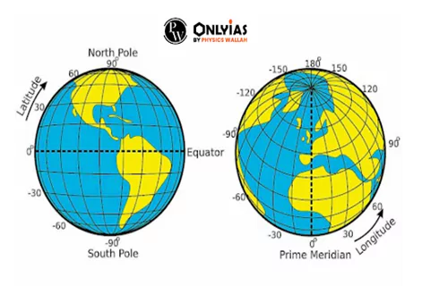
The Earth is a vast sphere, and to precisely locate points on its surface, we rely on a grid system known as latitude and longitude. Parallels, such as the Tropic of Capricorn, are lines of latitude that run horizontally, measuring distances north and south of the equator.
Meridians, on the other hand, are lines of longitude that run vertically, helping us measure distances east and west from the Prime Meridian. Understanding key parallels like the Tropic of Capricorn and meridians is essential for navigation and pinpointing locations worldwide.
The Globe: A Representation of Earth in Three Dimensions – Navigating Earth’s Dimensions with a Glimpse at the Tropic of Capricorn #
- About GLobe: The globe is a spherical model that serves as a three-dimensional representation of Earth.
- It provides a valuable tool for studying and understanding our planet’s geography and the spatial relationships between different locations.
Sphere as Earth’s Model: Sphere and Tropic of Capricorn #
- The globe is designed as a scaled-down, spherical model of the Earth.
- This shape closely approximates the actual shape of our planet, incorporating prominent features such as the Tropic of Capricorn
Geographic Coordinates: #
- The globe features a grid system of geographic coordinates, including lines of latitude and longitude, such as the Tropic of Capricorn, which are used to locate and identify specific points on Earth’s surface.
Exploring Earth: Our Blue Planet in Numbers – Traversing the Tropic of Capricorn #
Earth, often referred to as the “Blue Planet” due to its abundant water bodies, is a remarkable celestial body with unique characteristics and dimensions, including significant geographical features like the Tropic of Capricorn.
- Water-Covered World: Approximately two-thirds (2/3) of Earth’s surface is covered by water, making it a predominantly aqueous planet.
- Solar Distance: Earth orbits the Sun at an average distance of approximately 149 million kilometers (about 93 million miles).
- This distance varies slightly due to the elliptical shape of Earth’s orbit.
- Geoid Shape: Earth’s shape is best described as a geoid, which means it is slightly flattened at the poles and bulging at the equator.
- This shape is often referred to as an “oblate spheroid.”
- Equatorial and Polar Dimensions: The diameter of Earth at the equator measures about 12,756 kilometers (about 7,926 miles).
- In contrast, at the poles, Earth’s diameter is slightly smaller, measuring approximately 12,713.6 kilometers.
- Varied Rotational Speed: Earth’s rotation on its axis is not uniform across its surface. The speed of rotation is fastest at the equator, where it reaches approximately 1,600 kilometers per hour (about 994 miles per hour).
- As you move poleward, the rotational speed gradually decreases.
Understanding Latitudes: Earth’s Geographic Grid – Navigating the Tropic of Capricorn on Earth’s Grid #
Latitudes and longitudes are fundamental components of the geographic grid used to precisely determine locations on Earth’s surface.

- Definition of Latitudes: Latitudes are horizontal imaginary lines on the Earth’s surface.
- They measure the angular distance of a location, indicating whether it is north or south in relation to the equator.
- Parallel Circles: When observed from the Earth’s poles, latitudes resemble concentric circles with varying diameters.
- This characteristic gives them the name “Parallels of Latitudes.”
- Measurement in Degrees: Latitudes are measured in degrees (°).
- Each latitude is divided into 60 minutes (‘), and each minute is further divided into 3600 seconds (“).
- For instance, 1° equals 60 minutes, and 1 minute equals 60 seconds.
- Range of Latitudes: Earth’s latitudes are numerous, forming circles of various sizes.
- The largest latitude is the equator, located at 0° latitude.
- The equator is a reference line that divides the Earth into the Northern Hemisphere and the Southern Hemisphere.
- The shortest latitudes are at the poles, specifically the North Pole (90° latitude North) and the South Pole (90° latitude South).
- Earth has a total of 181 latitudes, each with a unique degree of inclination from the equator.
- Circles of Latitude: Each latitude represents an imaginary circle that connects all points situated along that parallel.
- These circles help define the positioning of locations on Earth.
- Consistent Spacing: The distance between two consecutive 1° latitudes remains relatively consistent, approximately at 111 kilometers (about 69 miles).
- This uniformity is due to the parallel nature of latitudes.
The Equator: Earth’s Geographical Divider – Navigating Earth’s Hemispheres and Equinoxes with the Tropic of Capricorn #
The equator is a prominent line of latitude on Earth’s surface with significant geographical and climatic implications.

- Definition: The equator is an imaginary line of latitude that intersects the Earth’s surface at its center.
- Location: It runs perpendicular to the axis of the Earth’s rotation and divides the planet into two equal halves – the Northern Hemisphere and the Southern Hemisphere.
- Equatorial Circle: The equator creates an equatorial circle, which is a circle on the Earth’s surface formed by connecting points lying on the equatorial plane.
- This circle encompasses locations near the equator.
- Hemispheric Division: The equator serves as a fundamental reference point for dividing the Earth into two primary hemispheres:
- North Hemisphere: Locations north of the equator, denoted by the letter “N.”
- South Hemisphere: Locations south of the equator, denoted by the letter “S.”
- Varied Latitude Sizes: As you move from the equator toward the poles, the size of latitudes gradually decreases.
- This variation in latitude sizes is due to the Earth’s oblate spheroid shape.
- Equinox Events: Twice a year, on March 21st and September 22nd, the Sun shines directly over the equator. These events are known as equinoxes:
- Vernal Equinox (March 21st): Also called the Spring Equinox.
- It signifies the beginning of spring in the Northern Hemisphere and autumn in the Southern Hemisphere.
- Autumn Equinox (September 22nd): Marks the start of autumn in the Northern Hemisphere and spring in the Southern Hemisphere.
- Vernal Equinox (March 21st): Also called the Spring Equinox.
|
Countries along the Equator |
|
| South America | Ecuador, Colombia, and Brazil |
| Africa | Sao Tome and Principe, Gabon, Congo, Democratic Republic of Congo, Uganda, Kenya, and Somalia |
| Asia | Maldives, Indonesia, and Kiribati |
Tropical Circles: Where the Sun Takes Center Stage – Tropic of Capricorn’s Celestial Spotlight #
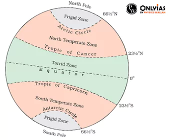
The two tropical circles, the Tropic of Cancer and the Tropic of Capricorn, play a significant role in Earth’s celestial theater.
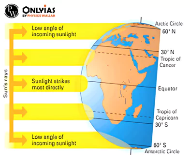
- Tropic of Cancer (23½° N): Located at approximately 23½ degrees north of the equator, the Tropic of Cancer is in the Northern Hemisphere.

-
- It represents the northernmost position on Earth where the Sun can appear directly overhead at least once a year.
- This phenomenon results in a day with no shadows due to the Sun’s vertical position.
- Tropic of Capricorn (23½° S): Positioned at approximately 23½ degrees south of the equator, the Tropic of Capricorn is situated in the Southern Hemisphere.
- It marks the southernmost latitude on Earth where the Sun can be directly overhead, creating a day without shadows once a year.
- No Overhead Sun Beyond the Tropics: Beyond Tropic of Capricorn and Tropic of Cancer, the Sun is never positioned directly overhead throughout the year.

-
- This leads to variations in daylight and shadow angles.
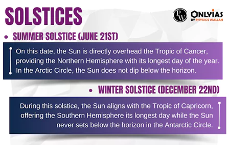
- Solstices and Sun’s Position: The relationship between the Tropic of Capricorn and the Sun is especially significant during the solstices.
Do You Know?
|
|
Tropic of Cancer passes through Countries |
|
| North America | Bahamas (Archipelago), Mexico |
| Africa | Egypt, Libya, Niger, Algeria, Mali, Western Sahara, Mauritania |
| Asia | Taiwan, China, Myanmar, Bangladesh, India, Oman, UAE, Saudi Arabia |
| India | Gujarat, Rajasthan, Madhya Pradesh, Chhattisgarh, Jharkhand, West Bengal, Tripura, and Mizoram |
|
Tropic of Capricorn passes through Countries |
|
| South America | Argentina, Brazil, Chile, Paraguay |
| Africa | Namibia, Botswana, South Africa, Mozambique, Madagascar |
| Australia | |
Exploring Polar Circles and the Poles: Earth’s Extremes – Tropic of Capricorn’s Journey to Earth’s Poles and Beyond #
Polar circles and the Earth’s poles are extreme latitudinal locations with unique features and celestial phenomena.
- Polar Circles: There are two polar circles on Earth:
- Arctic Circle (66½°N): Located in the Northern Hemisphere, it represents the northernmost circle where, at least once a year, the length of a day or night becomes 24 hours.
- Antarctic Circle (66½°S): Situated in the Southern Hemisphere, it marks the southernmost latitude where the same 24-hour day/night phenomenon occurs (with opposite dates to the Arctic Circle).
- The Polar Day and Night: Beyond the polar circles, in the Arctic and Antarctic regions, there is a time during the year when the Sun does not set or rise for a continuous 24-hour period. This phenomenon is experienced as follows:
- Northern Hemisphere: The Arctic Circle witnesses 24 hours of daylight on June 22nd, while 24 hours of darkness occurs on December 22nd.
- Southern Hemisphere: The Antarctic Circle experiences the opposite: 24 hours of daylight on December 22nd and 24 hours of darkness on June 22nd.
- The Poles (North and South): The North Pole is the northernmost point on Earth, situated at 90°N latitude.
- It marks the axis of the Earth’s northern rotation.
- The South Pole is the corresponding southernmost point on Earth, positioned at 90°S latitude.
- All lines of longitude converge at this point, making it a unique location.
- Seasonal Sun at the Poles: At the North Pole (Northern Hemisphere), the Sun follows an extraordinary annual cycle:
- From March, the Sun rises and continues to ascend for three months, reaching its zenith on June 21st, especially in regions near the Tropic of Capricorn.
- Following this, it begins to set, and for the next three months, the pole experiences continuous darkness.
- During the equinox, the Sun is precisely at the horizon, resulting in a full 24-hour day or night.
| Previous Year Question (Prelims)
Q. On 21st June, the Sun________________________(2019)
Ans: a Q. In the Northern Hemisphere, the longest day of the year normally occurs in the: (2022)
Ans: b |

 GS Foundation
 Crash Course
 Combo
Combo Optional Courses
 Degree Program


