Introduction: Alfred Wegener’s Continental Drift Theory
This article discusses Alfred Wegener’s 1912 theory of continental drift, which proposed that all continents were once part of a supercontinent called Pangaea. Evidence supporting this theory includes matching coastlines, correlated rock formations, and fossil distribution. It introduces the concept of plate tectonics and highlights the collision of the Indian Plate with the Eurasian Plate, leading to the formation of the Himalayas.
Continental Drift: Alfred Wegener’s Pangaea Hypothesis
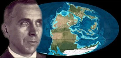
- Alfred Wegener, a German meteorologist, introduced the theory in 1912.
- His theory addressed the distribution of continents and oceans.
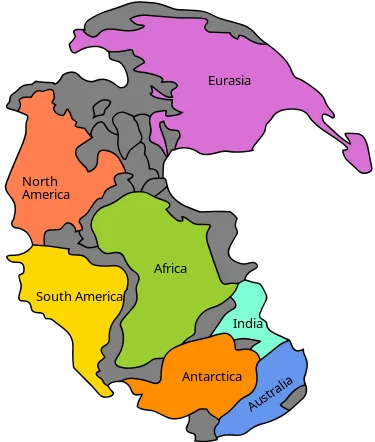
- Wegener proposed that all continents once comprised a single landmass, known as Pangaea, surrounded by a vast ocean named Panthalassa.
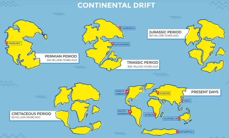
- Approximately 200 million years ago, Pangaea began to split.
- Initially, it was divided into two large landmasses, Laurasia and Gondwanaland, forming the northern and southern components.
- Over time, Laurasia and Gondwanaland further fragmented into the smaller continents we recognize today.
Evidence in Support of the Continental Drift: Rock-Solid Proof
Continental Jigsaw Puzzle: Deciphering the Puzzle Pieces of Africa and South America
- The shorelines of Africa and South America exhibit a striking and unmistakable alignment, resembling a jigsaw puzzle.
- In 1964, Bullard used computer mapping to demonstrate a nearly perfect fit of the Atlantic margin, employing the 1,000-fathom line instead of the current coastline.
Rocks Across Oceans: Connecting Ancient Rocks Across Oceans
- Recent advances in radiometric dating have enabled the correlation of rock formations across vast ocean expanses.
- Ancient rocks, dating back 2,000 million years, along the Brazilian coast match those in Western Africa.
- Marine deposits along the South American and African coastlines from the Jurassic age suggest an absence of the ocean before this period.
Evidence from Glacial Tillite: Unearthing Evidence of Continental Drift
- Glacial tillite, a sedimentary rock formed from glacier deposits, offers substantial evidence.
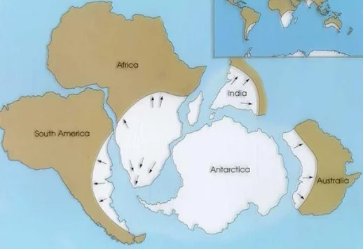
- The Gondwana sedimentary system in India shares counterparts in six different Southern Hemisphere landmasses.
- Thick tillite layers at the base indicate extensive and prolonged glaciation, with similar successions found in Africa, the Falkland Islands, Madagascar, Antarctica, Australia, and India.
Gold Placer Deposits: Exploring the Origins of Ghana’s Rich Placer Deposits
- Ghana’s coast boasts rich placer deposits of gold, perplexingly absent of a local source rock.
- The presence of gold–bearing veins in Brazil suggests that the gold deposits in Ghana originated from Brazil, potentially when the two continents were adjacent.
Fossil Distribution: Exploring Fossil Mysteries Across Distant Lands
- The distribution of identical species of land and freshwater-adapted plants and animals on opposite sides of marine barriers presents a challenge.
- Lemurs found in India, Madagascar, and Africa have led some to consider the existence of a connected landmass called “Lemuria.”
- Mesosaurus, a small reptile adapted to shallow brackish water, is found solely in two distant locations: the Southern Cape province of South Africa and the Iraver formations in Brazil, separated by a 4,800 km expanse of ocean.
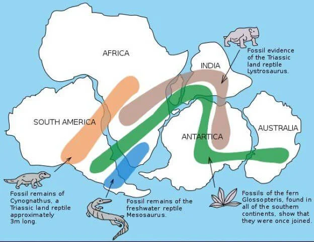
Forces Behind Continental Drift According to Wegener: Driving Forces of Change
- Polar-Fleeing Force and Tidal Force: Wegener proposed two forces as the driving factors behind continental drift: the polar-fleeing force and the tidal force.
- Polar-Fleeing Force and Earth’s Shape: The polar-fleeing force is closely linked to the Earth’s rotation and its non-spherical shape, with a noticeable bulge at the equator.
- Bulge Due to Earth’s Rotation:Earth’s bulge at the equator results from its rotational motion, which Wegener considered a crucial element in the drifting of continents.
- Tidal Force and Its Origin: The second force, the tidal force, arises from the gravitational pull of the moon and the sun, leading to the creation of tides in the world’s oceans.
- Time Scale of Wegener’s Theory: Wegener believed that these forces would gradually shape the continents over the course of many millions of years.
- Skepticism Among Scholars: Despite Wegener’s propositions, the majority of scholars of his time regarded these forces as insufficient to explain continental drift.
Post-Drift Studies: Beyond Continental Drift
- Continental drift research mainly relied on evidence from continental drift, such as the distribution of plants and animals, and deposits like tillite.
- After World War II, several significant discoveries contributed to geological knowledge, expanding the existing literature.
- Ocean floor mapping in the post-war era offered fresh insights into the relationships between oceans and continents.
Convectional Current Theory: Arthur Holmes’ Theory and Continental Drift Rejection
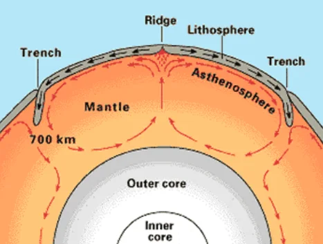
- Arthur Holmes, in the 1930s, proposed the concept of convection currents in the Earth’s mantle.
- These currents result from heat generated by radioactive elements, causing variations in mantle temperature.
- Holmes postulated a comprehensive system of such currents throughout the mantle as an explanation for the forces that led to the rejection of continental drift theory by contemporary scientists.
Mapping of the Ocean Floor: Mapping the Depths and Discovering Earth’s Dynamic Geology
- Extensive research of the ocean floor revealed its complex topography, dispelling the notion of a uniform, flat seabed.
- Post-World War II oceanic expeditions provided detailed insights into ocean relief, unveiling submerged mountain ranges and deep trenches, mainly near continental drift margins.
- Mid-oceanic ridges, characterized by intense volcanic activity, were found to be highly dynamic.
- Dating of oceanic crust rocks showed their relative youth compared to continental drift, supporting a new understanding of Earth’s geology.
Ocean Floor Configuration: Exploring Ocean Floor
- Continental Margins: The Interface of Continents and Deep-Sea Realms
- Transitional zones between continents and deep-sea basins.
- Comprise continental shelf,
- Continental slope,
- Continental rise, and
- Deep-oceanic trenches.
- Deep-oceanic trenches are particularly significant in the context of ocean and continent distribution.
- Transitional zones between continents and deep-sea basins.
- Abyssal Plains: Earth’s Submerged Flatland
- Vast, flat expanses located between continental drift and mid-oceanic ridges.
- Accumulation areas for sediments transported from continental drift.
- Mid-Oceanic Ridges: Earth’s Underwater Mountain Chains
- An interconnected chain of underwater mountain systems, constituting the Earth’s longest mountain range, is a key component of the phenomenon known as continental drift
- Submerged beneath oceanic waters.
- Distinguished by a central rift system, a segmented plateau, and a flank zone, all extending along its length.
- The rift system at the crest is characterized by intense volcanic activity.
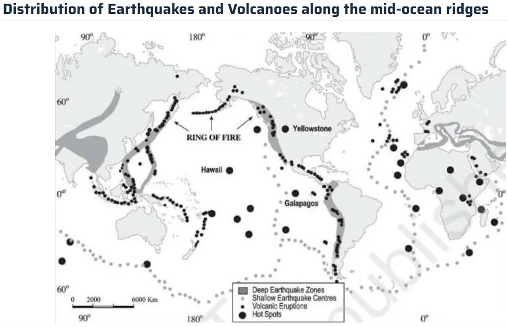
Distribution of Earthquakes and Volcanoes: The Role of Plate Tectonics
- Plate tectonics are responsible for the occurrence of earthquakes and volcanoes.
- Regions where two tectonic plates meet are termed plate boundaries.
- Earthquakes and volcanoes tend to be concentrated around or in close proximity to these plate boundaries.
- Earthquakes occurring along mid-oceanic ridges usually have shallow focal points, while those within the Alpine-Himalayan belt and the Pacific rim are typically deeper.
- The Pacific rim, often referred to as the “Ring of Fire,” is known for its abundance of active volcanoes.
| Hotspots: Volcanic Activity Beyond Plate Boundaries |
Unusual Volcanic Locations
Defining Hotspots
Stationary and Unique
Prominent Hotspots
These hotspots provide a distinctive perspective on volcanic activity, occurring independently of traditional plate boundaries. |

 GS Foundation
 Optional Course
 Combo Courses
 Degree Program


