Introduction
Volcanoes, with their explosive power and transformative capabilities, offer a vivid window into the Earth’s ever-changing nature. In this exploration, we will uncover the diverse world of volcano landforms, their formation processes, and their profound influence on our planet’s topography.
Exploring Different Volcanic Landforms on Earth
- Understanding Volcanicity :
- Dynamic Interplay: Landforms created by volcanoes are the result of the dynamic interplay between the Earth’s molten core and its solid surface.
- These geological features, shaped by fiery eruptions and the ceaseless forces beneath our feet, offer a remarkable tapestry of landscapes that stretch from the depths of the ocean to towering peaks that touch the sky .

- Types of Volcanic Landforms
- Volcanic landforms are differentiated based on location of occurrence of landforms.
- Generally , there are two type of volcanic landform which is inside the earth’s surface called intrusive landform and above the land surface called extrusive landform
- Extrusive Landforms: Landforms which are determined by the nature and composition of lava and other ejected materials which reach the surface of the earth.
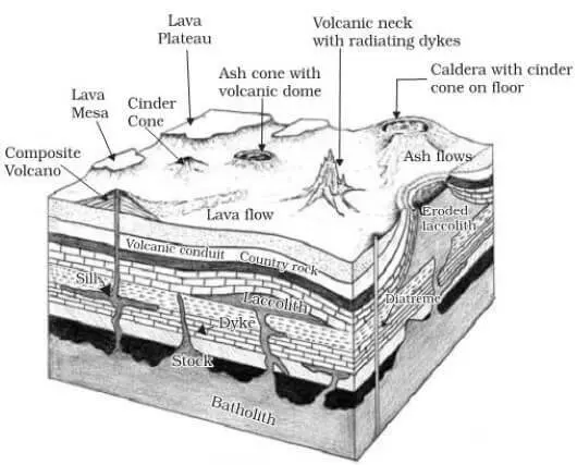
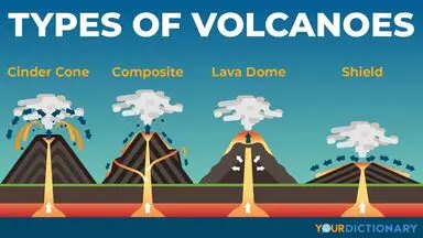
- Volcanic cones : Volcanic cones are mound-shaped landforms that build up around a volcanic vent or crater as a result of the accumulation of lava, ash, and volcanic debris during eruptions.
- These are most typical of extrusive volcanic landforms.
| StratoVolcano |
|
| Parasite Cones |
|
| Shield Volcano
/BASIC LAVA DOME |
|
| Lava Dome |
|
Lava plateau : A lava plateau, also known as a volcanic plateau or basalt plateau, is a type of large, nearly flat or gently sloping landform that is primarily created by the accumulation of lava flows over a wide area.
- These landforms are typically the result of effusive volcanic eruptions, where low-viscosity basaltic lava erupts from long fissures or cracks in the Earth’s crust, allowing the lava to spread out over a broad region.
- Example – Deccan Lava Plateau , Snake Basin USA
- Craters and Caldera : Volcanic craters are bowl-shaped depressions at the summit of a volcano, created by a combination of volcanic activity and geological processes.
- When this crater is filled with water it becomes a crater lake Such as crater lake in Oregon, USA .
- Generally geographers believe that caldera is an enlarged form of crater which is formed due to violent and explosive volcanic eruptions.
- Some geographers have also pointed out that caldera is formed due to subsidence of the crater .
- The exact answer to formation of caldera is still not known .
- The famous example of caldera is Lake Toba of Sumatra ,Lake Aira of Japan .
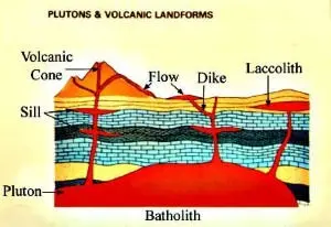
- Intrusive Landform: Intrusive landforms of volcanoes are features created beneath the Earth’s surface as a result of the cooling and solidification of magma.
-
-
- Unlike extrusive landforms, which are formed by volcanic material erupting and accumulating on the surface, intrusive landforms result from the emplacement of magma into pre-existing rock formations.
- Dikes: These are tabular or sheet-like intrusions of magma that cut across the existing rock layers.
- They form when magma is injected into fractures, joints, or other openings in the Earth’s crust and then solidifies.
- Dikes are typically vertical or near-vertical and can be found in a variety of geological settings.
-
- Sills: These are horizontal or near-horizontal intrusions of magma that are parallel to the existing rock layers.
- They form when magma is injected between layers of pre-existing rock and then cools and solidifies.
- Sills can create distinctive flat-topped ridges or outcrops.
- Example – The great whin sill of england
- Laccoliths: These are lens-shaped intrusions of magma that push up overlying rock layers, creating a dome-like structure.
- They are the result from the slow accumulation of magma beneath the Earth’s surface, causing the overlying rock to bulge upward.
- They can produce topographic features with a characteristic mushroom or blister shape.
- Example -Henery mountain laccolith in usa
- Lopolith: These are saucer shaped/ bowl-like shapes, with a central depression where the magma has pooled and a raised rim formed by the overlying rock layers.
- Example -Bushveld lopolith of South Africa .
- Phacolith: It is a lens shaped mass of igneous rocks occupying the crest of an anticline or the bottom of syncline .
- Example – Phacolith of corndon hill in shropshire , England .

- Batholiths: These are the largest and most massive intrusive landforms.
- They are massive bodies of intrusive rock that extend over vast areas.
- Batholiths are typically composed of granite or other intrusive igneous rocks and can be exposed at the Earth’s surface due to erosion.
- Plutons: The term “pluton” is a general term used to describe any body of intrusive igneous rock that has solidified beneath the Earth’s surface.
- This can include dikes, sills, laccoliths, batholiths, stocks, and other intrusions.
- Pseudo Volcanic Landform: These are topographic features that resemble volcanic landforms yet they don’t have volcanic origin.
- They can be as followed:
| Meteorite Craters |
|
| Salt plug or salt dome |
|
| Mud-Volcanoes |
|
Conclusion
Volcanic landforms, from cones to intrusions, reveal Earth’s ever-changing nature. Magma, eruptions, and geological forces shape our landforms, showcasing the planet’s dynamic evolution.

 GS Foundation
 Optional Course
 Combo Courses
 Degree Program


