Introduction – Volcanic Patterns: A Journey into Geologic History and Tectonic Forces
The distribution of volcanoes on Earth is a dynamic and intricate pattern that provides a fascinating glimpse into the planet’s geologic history and tectonic processes. Volcanoes are not randomly scattered across the globe but are concentrated in specific regions, often associated with plate boundaries and hotspots.
The distribution of volcanoes reflects the profound interactions between the Earth’s lithospheric plates, the underlying mantle, and the forces at play deep within the planet.
Distribution Of Volcanoes – Patterns, Seismic Connections, and Tectonic Relationships
- Zonal Distribution of volcanoes : The distribution of volcanoes over the globe is well marked and well understood because volcanoes are found in well defined belts or zones .
- Thus , the pattern of distribution of volcanoes is zonal in nature .
- Seismic Active Zone : As we know , volcanic activity is associated with a weaker zone of crust which is closely associated with seismic activity .
- Thus these weaker zones are represented by the fold mountains ( andes , western cordillera of north america etc ) , meeting zones of the continent and ocean such as the phillipian region .
- According to plate tectonics: there is a close relationship between plate margins and vulcanicity
- Different Type of Volcano :About 15% of total volcanoes are found along constructive plate margin and 80% is found along the destructive plate boundary / constructive plate boundary.
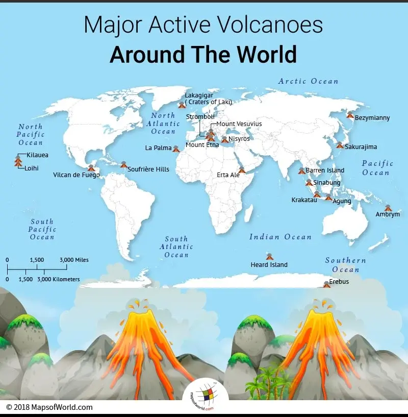
FIG- VOLCANO ACROSS WORLD

There are three major zones of volcano across the world: Distribution of Volcanoes
- Circum -Pacific Belt
- Mid Continental Belt
- Mid Atlantic Belt
Circum Pacific Belt: Distribution of Volcanoes
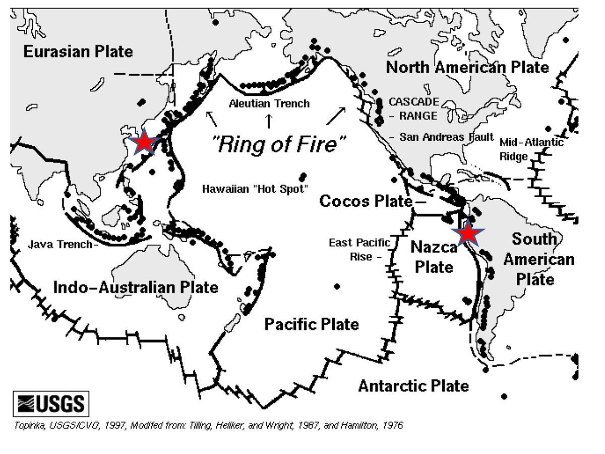
- Description: The Circum-Pacific Belt, often referred to as the “Ring of Fire,” is a horseshoe-shaped zone encircling the Pacific Ocean.
- It’s renowned for its intense volcanic and seismic activity, making it one of the most geologically active regions on Earth.
- Key Features: This belt is home to numerous volcanoes, along with tectonic plate boundaries and geological features shaped by the interaction of the Pacific Plate with neighbouring plates.
- There is the presence of caldera , Phreatomagmatic features and geysers , hot springs etc .
- Tectonic Plate Interactions: The volcanic activity in the Circum-Pacific Belt is predominantly driven by the complex interactions of major tectonic plates.
- Subduction zones, where one plate is forced beneath another, play a pivotal role in volcanic eruptions and seismic events.
- Key Locations: Notable subduction zones include the Pacific Plate subducting beneath the North American Plate along the west coast of the United States, as well as the Nazca Plate subducting beneath the South American Plate in the Andes.
- Types of Volcanoes: The Circum-Pacific Belt features a variety of volcano types, including stratovolcanoes, shield volcanoes, and cinder cones.
- Each type results from different magma compositions and eruption styles.
- Key Examples: Well-known volcanoes in the Ring of Fire include Mount St. Helens, a stratovolcano in the United States.
- Mauna Loa, a massive shield volcano in Hawaii.
- Hazards and Global Impacts: The high volcanic and seismic activity in the Circum-Pacific Belt poses potential hazards to human populations living in these regions.
- Additionally, massive volcanic eruptions in this belt can have global climatic impacts due to the injection of volcanic ash and gases into the atmosphere.
- Notable eruptions like the 1991 Pinatubo eruption in the Philippines and the 1815 Tambora eruption in Indonesia had far-reaching global consequences.
- Research and development: The scientific study of volcanoes in the Circum-Pacific Belt is crucial for understanding volcanic hazards, predicting eruptions, and improving disaster preparedness.
- Researchers and monitoring agencies continuously assess and analyse volcanic activity in this region.

Mid Continental Belt: Distribution of Volcanoes
- Description: The Mid-Continental Belt is characterised by ancient volcanic rocks, estimated to be around 1.1 billion years old.
- This volcanic activity predates the more well-known volcanic regions associated with plate boundaries.
- Geological Significance:The existence of ancient volcanic rocks in this region provides crucial insights into Earth’s geological history and the dynamics of continental rifting.
- Location : This belt include volcano of Alpine mountain chain and Mediterranean sea
- The famous volcanoes of this belt are – stromboli , Vesuvius , karakoram .
- Rift Zone and Continental Rifting: The Midcontinent Rift represents a failed rift zone within the North American continent.
- It was an attempt by the continent to split apart, similar to what occurs at present-day rift zones like the East African Rift.
- Formation: The rift formed due to the upwelling of magma beneath the continent, creating a rift valley, which eventually filled with lava.
- Volcanic Feature: The volcanic features in this belt include layers of basaltic lava flows, volcanic rocks, and sedimentary deposits.
- These rocks are exposed in certain areas, providing valuable geological information.
-
- Landscape: The volcanic features have contributed to the unique landscape of the region, which includes rugged terrain, hills, and lakes formed within the rift valley.
- Limited Modern Volcanic Activity: Unlike the active volcanoes found in subduction zones and hotspots, the Mid-Continental Belt is not associated with ongoing volcanic activity.
- The volcanic activity in this region ceased long ago.
- The region serves as a geological legacy, preserving evidence of a unique chapter in Earth’s history when a continent tried to split apart.
- Natural Beauty and Recreation: The unique geological features, including lava flows and lakes, make the Mid-Continental Belt an attractive destination for outdoor activities, hiking, and exploration.
- Tourism: The region has become a source of tourism, allowing visitors to appreciate both its geological history and its scenic beauty.
Mid Atlantic Belt: Underwater Landscape Distribution of Volcanoes Description:The Mid-Atlantic Ridge is a massive underwater mountain range that stretches down the centre of the Atlantic Ocean.
-
- Size and Location: The Mid-Atlantic Ridge distribution of volcanoes extends for over 16,000 kilometres (about 10,000 miles) from the Arctic Ocean in the north to the Southern Ocean in the south.
- It is S -shaped and located in the centre of the Atlantic Ocean .
- Size and Location: The Mid-Atlantic Ridge distribution of volcanoes extends for over 16,000 kilometres (about 10,000 miles) from the Arctic Ocean in the north to the Southern Ocean in the south.
- Formation and Tectonic Significance: It is a prominent geological feature formed by the interaction of tectonic plates and serves as a key component of the global system of mid-ocean ridges
- The Mid-Atlantic Ridge distribution of volcanoes is the result of a divergent plate boundary, where the Eurasian and North American tectonic plates are moving apart.
- As these plates separate, magma from the Earth’s mantle rises to form a new oceanic crust. This process is central to the theory of plate tectonics.
-
- Magma and Volcanism: Volcanic activity is a defining characteristic of the Mid-Atlantic Ridge, as magma reaches the seafloor, solidifies, and accumulates over time, forming underwater volcanic features distribution of volcanoes.
- Volcanic Features and Landforms: The volcanic activity along the Mid-Atlantic Ridge gives rise to these including seamounts (underwater mountains), volcanic islands, rift valleys, and hydrothermal vent systems.
- One of the most remarkable features is the presence of hydrothermal vents, where superheated water rich in minerals escapes from the Earth’s crust.
- These vents create unique ecosystems supported by chemosynthetic bacteria.
- Oceanic Crust Formation: The Mid-Atlantic Ridge is where new oceanic crust is continually generated.
- As magma cools and solidifies, it forms basaltic rock, contributing to the expansion of the seafloor and the Atlantic Ocean itself.
- The crust’s age increases with distance from the ridge crest, allowing scientists to map the history of seafloor spreading.
Intraplate Volcano: Distribution of Volcanoes
- Intraplate volcanoes, also known as hotspot volcanoes, defy conventional geological wisdom by emerging far from tectonic plate boundaries.
- Formation: It is attributed to the presence of a deep-seated mantle plume—an upwelling of extremely hot mantle material.
- As this plume breaches the Earth’s crust, it creates a localised hotspot for volcanic activity.
- Over time, the consistent upwelling of molten rock forms a volcanic island or a volcanic field on a continental plate.
- The process is distinct from the more common plate boundary volcanoes, such as those found along the Pacific Ring of Fire.
- Example :
- Hawaiian island
-
- Yellowstone caldera
Significance of Volcano:
- Evidence of Plate Movements: These are tangible evidence of the ongoing movement of Earth’s tectonic plates.
- The distribution of volcanoes along plate boundaries and hotspots helps geologists map and study plate interactions.
- Land Building and Destruction: These create new landforms, including islands and mountain ranges. Conversely, volcanic eruptions can also lead to the destruction of landscapes.
- They play a pivotal role in shaping Earth’s ever-changing geography.
- Unique Landscapes and Habitats: Volcanic landscapes, such as lava plateaus and volcanic islands, offer unique habitats for flora and fauna.
- Some species have evolved to thrive in the challenging conditions of volcanic regions.
- Geothermal Energy Source: Volcanic regions often provide access to geothermal energy sources.
- Geothermal power plants use heat from the Earth’s interior to generate electricity, offering a sustainable and clean energy option.
- Mineral and Resource Deposits: Volcanic activity can concentrate valuable minerals and resources, including metals and gemstones.
- This distribution of volcanoes has economic significance in mining and resource extraction.
- Cultural and Historical Significance: Volcanoes have played an essential role in the cultural and historical narratives of many societies.
- They have inspired myths, legends, and art, influencing human cultures throughout history.
Hazardous Impact of volcano
- Pyroclastic Flows: Pyroclastic flows are fast-moving, high-temperature mixtures of gas, ash, and rock fragments
- They can race down the flanks of a volcano at hurricane-like speeds, devastating everything in their path.
- Lava Flows: Lava flows are a gradual but destructive hazard. They can consume homes, vegetation, and infrastructure, slowly advancing and smothering everything in their way.
- Ashfall: Ashfall can disrupt transportation, damage buildings, and pose respiratory health risks.
- Fine ash particles can remain suspended in the atmosphere, affecting air travel and regional climates.
- Volcanic Gases: Volcanoes emit a mix of noxious gases, including sulphur dioxide, carbon dioxide, and hydrogen sulphide
- These gases can be harmful to health and the environment and contribute to air pollution.
- Lahars: Lahars are fast-moving mudflows that can occur during or after eruptions, particularly in volcanic regions with glaciers or heavy rainfall.
- They can bury communities and infrastructure.
- Tephra Fall: Tephra fall refers to the accumulation of volcanic fragments, including rocks, ash, and pumice, on the ground.
- These fragments can damage buildings, block roads, and contaminate water supplies.
- Secondary Effects
- Triggering Tsunamis and Seismic Activity
- Global Cooling from Large Eruptions
- Economic and Infrastructure Damage
- Temporary or Permanent Relocation: Volcanic hazards can force communities to evacuate temporarily or, in some cases, permanently, displacing people from their homes.
Previous Year Mains Questions
|
Conclusion:
In summary, the distribution of volcanoes unveils Earth’s geological history and the intricate dance of tectonic forces, forming a captivating narrative across well-defined belts or zones. This distribution of volcanoes reflects the dynamic interplay between lithospheric plates, the underlying mantle, and the deep-seated forces shaping our planet.

 GS Foundation
 Optional Course
 Combo Courses
 Degree Program


